Uvalde County Sketch File 27
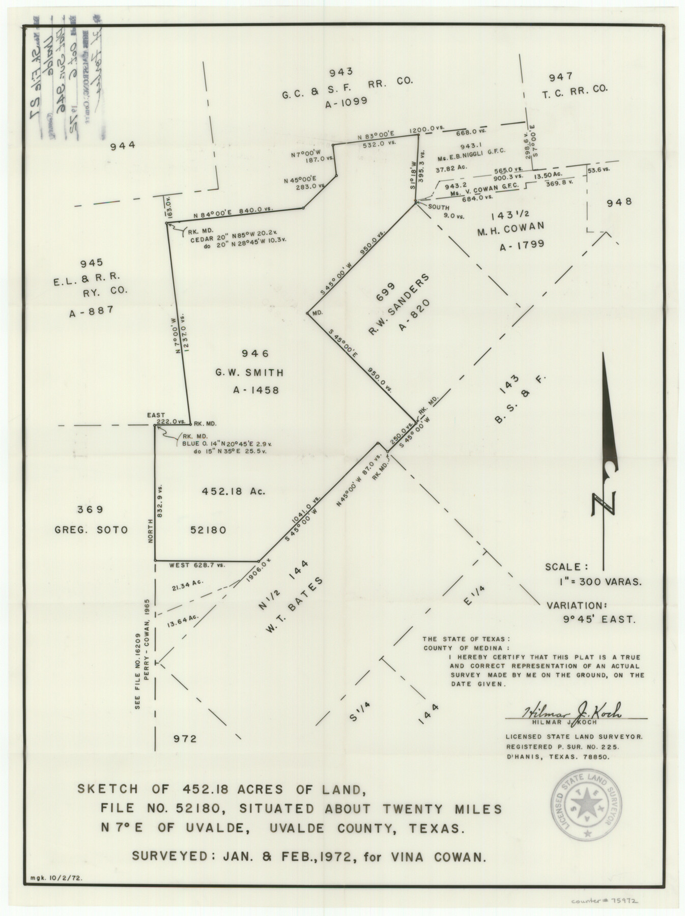
Sketch of 452.18 acres of land, file no. 52180 situated north of Uvalde
-
Map/Doc
75972
-
Collection
General Map Collection
-
Object Dates
10/2/1972 (Creation Date)
10/6/1972 (File Date)
Jan. & Feb. 1972 (Survey Date)
-
People and Organizations
Hilmar J. Koch (Surveyor/Engineer)
-
Counties
Uvalde
-
Subjects
Surveying Sketch File
-
Height x Width
18.7 x 14.0 inches
47.5 x 35.6 cm
-
Medium
mylar, print
-
Scale
1" = 300 varas
Part of: General Map Collection
Cherokee County Rolled Sketch 2

Print $20.00
- Digital $50.00
Cherokee County Rolled Sketch 2
1954
Size 44.6 x 36.0 inches
Map/Doc 8596
Upton County Rolled Sketch 25

Print $20.00
- Digital $50.00
Upton County Rolled Sketch 25
1941
Size 33.2 x 34.5 inches
Map/Doc 10044
Brewster County Working Sketch 81

Print $20.00
- Digital $50.00
Brewster County Working Sketch 81
1972
Size 45.9 x 26.7 inches
Map/Doc 67681
Dallas County

Print $20.00
- Digital $50.00
Dallas County
1942
Size 45.5 x 38.0 inches
Map/Doc 16954

Topographical Map of the Rio Grande, Sheet No. 13

Print $20.00
- Digital $50.00
Topographical Map of the Rio Grande, Sheet No. 13
1912
Map/Doc 89537
Kimble County Sketch File 43

Print $16.00
- Digital $50.00
Kimble County Sketch File 43
2021
Size 11.0 x 8.5 inches
Map/Doc 96811
Taylor County Working Sketch 9

Print $20.00
- Digital $50.00
Taylor County Working Sketch 9
1955
Size 24.2 x 24.6 inches
Map/Doc 69619
Map of Dickens County

Print $20.00
- Digital $50.00
Map of Dickens County
1899
Size 40.7 x 36.7 inches
Map/Doc 16822
Map of San Patricio District

Print $40.00
- Digital $50.00
Map of San Patricio District
1870
Size 43.8 x 51.4 inches
Map/Doc 1987
Flight Mission No. DAG-19K, Frame 59, Matagorda County

Print $20.00
- Digital $50.00
Flight Mission No. DAG-19K, Frame 59, Matagorda County
1952
Size 18.6 x 22.2 inches
Map/Doc 86386
Harbor Pass and Bar at Brazos Santiago, Texas

Print $20.00
- Digital $50.00
Harbor Pass and Bar at Brazos Santiago, Texas
1871
Size 18.2 x 26.8 inches
Map/Doc 72983
You may also like
Texas & Pacific Railway, Longview to Dallas

Print $40.00
- Digital $50.00
Texas & Pacific Railway, Longview to Dallas
1873
Size 14.8 x 100.8 inches
Map/Doc 64099
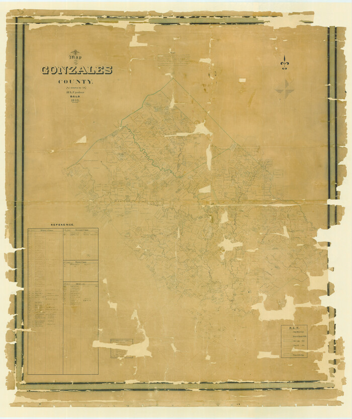
Map of Gonzales County
Print $40.00
- Digital $50.00
Map of Gonzales County
1842
Size 59.5 x 50.0 inches
Map/Doc 16839
Working Sketch in McMullen County

Print $20.00
- Digital $50.00
Working Sketch in McMullen County
1919
Size 20.3 x 31.7 inches
Map/Doc 91345
[Block 47, Sections 17- 29]
![91176, [Block 47, Sections 17- 29], Twichell Survey Records](https://historictexasmaps.com/wmedia_w700/maps/91176-1.tif.jpg)
Print $20.00
- Digital $50.00
[Block 47, Sections 17- 29]
Size 25.2 x 18.4 inches
Map/Doc 91176
Cass County Working Sketch 47b

Print $20.00
- Digital $50.00
Cass County Working Sketch 47b
1992
Size 32.3 x 36.4 inches
Map/Doc 76063
Eberstadt and Brock's Subdivisions of the West Half of Survey 187 Block 2 A. B. & M., Randall County Texas

Print $20.00
- Digital $50.00
Eberstadt and Brock's Subdivisions of the West Half of Survey 187 Block 2 A. B. & M., Randall County Texas
Size 17.7 x 29.6 inches
Map/Doc 91748
Real County Rolled Sketch JCA

Print $20.00
- Digital $50.00
Real County Rolled Sketch JCA
Size 27.9 x 36.5 inches
Map/Doc 7470
Kinney County Sketch File 23

Print $40.00
- Digital $50.00
Kinney County Sketch File 23
1901
Size 17.6 x 15.3 inches
Map/Doc 29162
Harbor Pass and Bar at Brazos Santiago, Texas

Print $20.00
- Digital $50.00
Harbor Pass and Bar at Brazos Santiago, Texas
1871
Size 18.1 x 27.4 inches
Map/Doc 73038
Working Sketch in Eastland County

Print $20.00
- Digital $50.00
Working Sketch in Eastland County
1919
Size 20.1 x 14.6 inches
Map/Doc 90931
Map Exhibit B, R. B. Violette, M. A. 34719, Gaines County, Texas

Print $20.00
- Digital $50.00
Map Exhibit B, R. B. Violette, M. A. 34719, Gaines County, Texas
Size 30.3 x 23.3 inches
Map/Doc 92654
The Chief Justice County of Sabine. Undated

Print $20.00
The Chief Justice County of Sabine. Undated
2020
Size 20.0 x 21.7 inches
Map/Doc 96068