Orange County Sketch File 4a
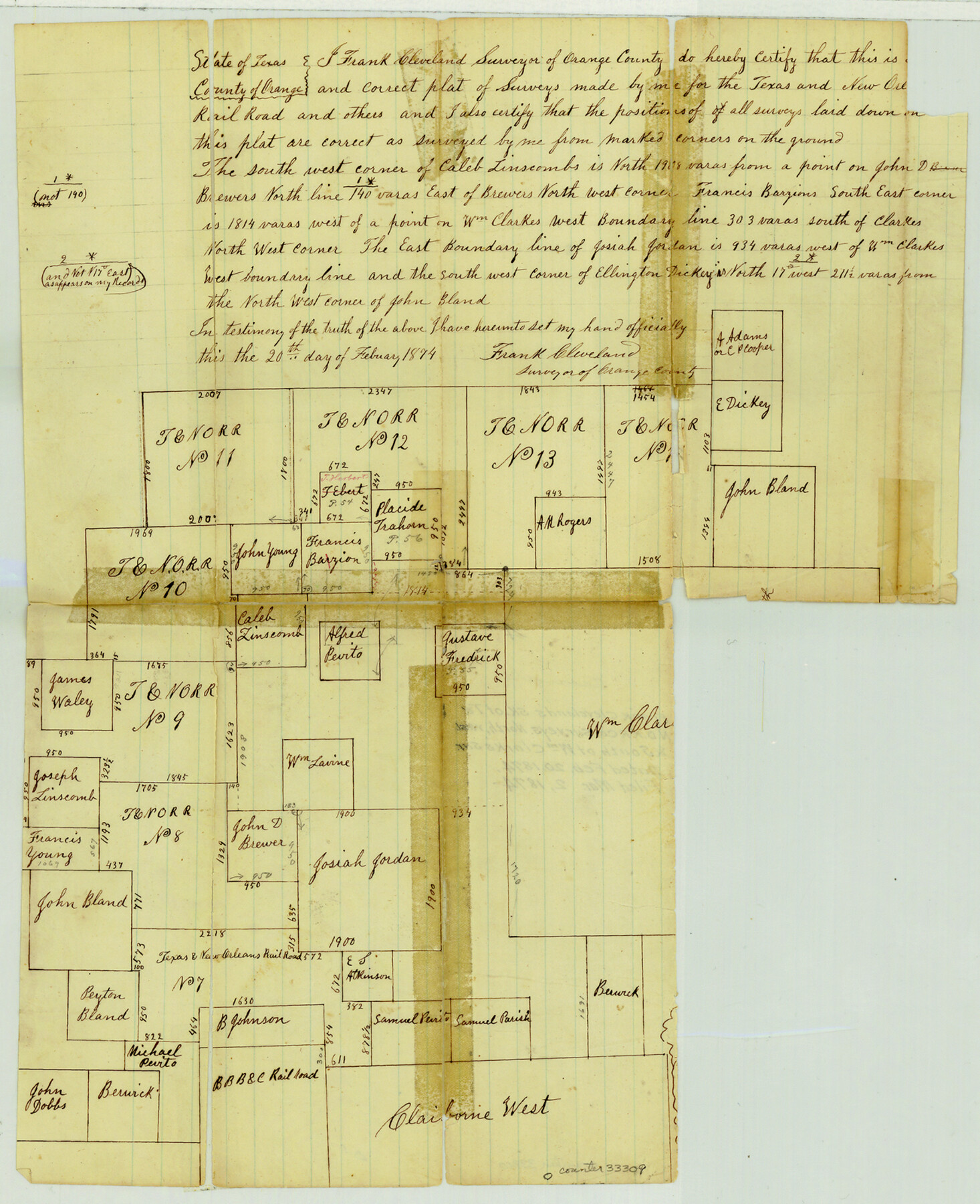
[Sketch of T. & N. O. R.R. Co. surveys north, west and south of William Clark's survey]
-
Map/Doc
33309
-
Collection
General Map Collection
-
Object Dates
2/20/1874 (Creation Date)
3/2/1874 (File Date)
-
People and Organizations
Frank Cleveland (Surveyor/Engineer)
-
Counties
Orange
-
Subjects
Surveying Sketch File
-
Height x Width
16.0 x 13.0 inches
40.6 x 33.0 cm
-
Medium
paper, manuscript
Part of: General Map Collection
Bee County Sketch File Y

Print $4.00
- Digital $50.00
Bee County Sketch File Y
Size 8.8 x 5.4 inches
Map/Doc 14255
Zapata County Sketch File 11

Print $6.00
- Digital $50.00
Zapata County Sketch File 11
1918
Size 14.4 x 8.7 inches
Map/Doc 40946
Henderson County Rolled Sketch 13

Print $20.00
- Digital $50.00
Henderson County Rolled Sketch 13
1987
Size 25.3 x 21.0 inches
Map/Doc 6205
Webb County Sketch File LM3

Print $20.00
- Digital $50.00
Webb County Sketch File LM3
1924
Size 24.7 x 31.9 inches
Map/Doc 12658
Kenedy County Rolled Sketch 18

Print $20.00
- Digital $50.00
Kenedy County Rolled Sketch 18
1995
Size 29.5 x 39.2 inches
Map/Doc 6472
Henderson County Sketch File 17

Print $40.00
- Digital $50.00
Henderson County Sketch File 17
Size 14.2 x 14.6 inches
Map/Doc 26361
McMullen County Sketch File 30

Print $20.00
- Digital $50.00
McMullen County Sketch File 30
1884
Size 38.5 x 21.1 inches
Map/Doc 10540
Duval County Rolled Sketch 16

Print $20.00
- Digital $50.00
Duval County Rolled Sketch 16
1940
Size 45.3 x 34.8 inches
Map/Doc 8810
Ochiltree County Working Sketch 7

Print $40.00
- Digital $50.00
Ochiltree County Working Sketch 7
1968
Size 26.8 x 56.6 inches
Map/Doc 71320
Map of McLennan County

Print $40.00
- Digital $50.00
Map of McLennan County
1896
Size 48.8 x 53.7 inches
Map/Doc 7952
Flight Mission No. DQO-1K, Frame 92, Galveston County

Print $20.00
- Digital $50.00
Flight Mission No. DQO-1K, Frame 92, Galveston County
1952
Size 18.9 x 22.6 inches
Map/Doc 84988
Parker County Rolled Sketch 2

Print $20.00
- Digital $50.00
Parker County Rolled Sketch 2
Size 32.4 x 19.6 inches
Map/Doc 7203
You may also like
Perspective Map of Fort Worth, Tex.

Print $20.00
Perspective Map of Fort Worth, Tex.
1891
Size 19.9 x 33.0 inches
Map/Doc 89083
San Saba County Boundary File 1

Print $4.00
- Digital $50.00
San Saba County Boundary File 1
Size 14.2 x 8.7 inches
Map/Doc 58575
Flight Mission No. DQN-5K, Frame 148, Calhoun County

Print $20.00
- Digital $50.00
Flight Mission No. DQN-5K, Frame 148, Calhoun County
1953
Size 18.6 x 21.9 inches
Map/Doc 84423
Eastland County Working Sketch 54

Print $20.00
- Digital $50.00
Eastland County Working Sketch 54
1984
Size 19.6 x 18.0 inches
Map/Doc 68835
Port Series No. 6 - The Ports of Galveston, Houston, and Texas City, Texas

Port Series No. 6 - The Ports of Galveston, Houston, and Texas City, Texas
1924
Map/Doc 97159
Flight Mission No. CGI-3N, Frame 95, Cameron County

Print $20.00
- Digital $50.00
Flight Mission No. CGI-3N, Frame 95, Cameron County
1954
Size 18.7 x 22.3 inches
Map/Doc 84575
Smith County Rolled Sketch 6B

Print $40.00
- Digital $50.00
Smith County Rolled Sketch 6B
1949
Size 91.7 x 38.5 inches
Map/Doc 10700
Presidio County Working Sketch 54

Print $20.00
- Digital $50.00
Presidio County Working Sketch 54
1955
Size 26.0 x 20.8 inches
Map/Doc 71731
Hudspeth County Sketch File 46

Print $20.00
- Digital $50.00
Hudspeth County Sketch File 46
1983
Size 17.5 x 14.0 inches
Map/Doc 27049
Blanco County Working Sketch 11

Print $3.00
- Digital $50.00
Blanco County Working Sketch 11
1941
Size 10.8 x 10.4 inches
Map/Doc 67371
Texas Intracoastal Waterway - Laguna Madre - Dagger Hill to Potrero Grande

Print $20.00
- Digital $50.00
Texas Intracoastal Waterway - Laguna Madre - Dagger Hill to Potrero Grande
1956
Size 38.6 x 27.2 inches
Map/Doc 73509
[Plat Showing Jeremiah Kirby, Champion Choat, A. M. Lejarza & Hardin Co. School Lands]
![5040, [Plat Showing Jeremiah Kirby, Champion Choat, A. M. Lejarza & Hardin Co. School Lands], Maddox Collection](https://historictexasmaps.com/wmedia_w700/maps/5040.tif.jpg)
Print $20.00
- Digital $50.00
[Plat Showing Jeremiah Kirby, Champion Choat, A. M. Lejarza & Hardin Co. School Lands]
Size 28.8 x 38.9 inches
Map/Doc 5040