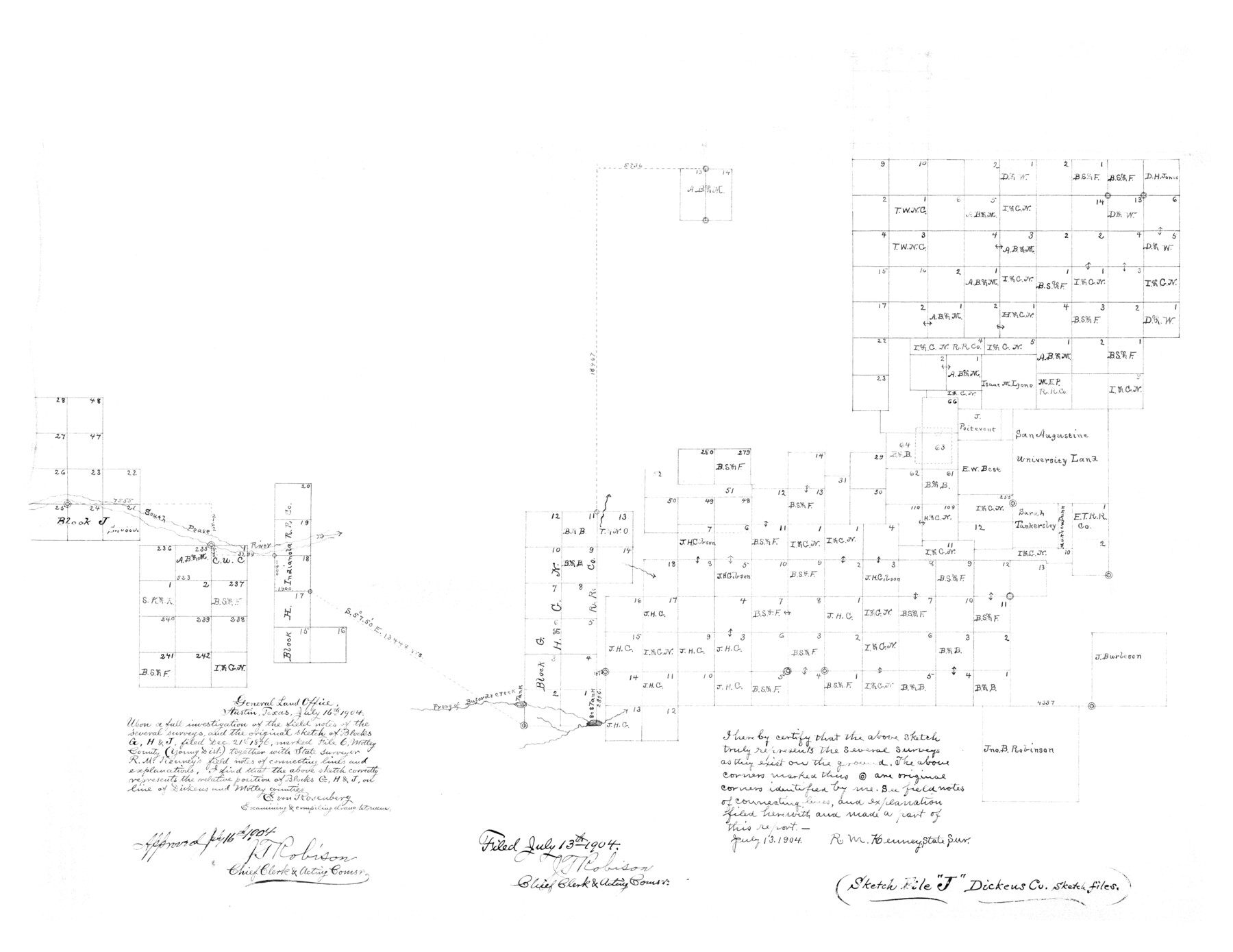
Dickens County Rolled Sketch J
Sketch in Dickens, Motley & Cottle Cos., Texas
-
Map/Doc
8781
-
Collection
General Map Collection
-
Object Dates
1904/7/13 (Creation Date)
1904/7/13 (File Date)
-
People and Organizations
R.M. Kenney (Surveyor/Engineer)
-
Counties
Dickens Motley Cottle
-
Subjects
Surveying Rolled Sketch
-
Height x Width
25.4 x 32.9 inches
64.5 x 83.6 cm
-
Comments
See Dickens County Sketch File 38 (21048) for calculation sheet.
Related maps
Dickens County Sketch File 38

Print $4.00
- Digital $50.00
Dickens County Sketch File 38
1904
Size 10.8 x 7.3 inches
Map/Doc 21048
Part of: General Map Collection
Surveys in Austin's Colony along the east fork of Mill Creek

Print $20.00
- Digital $50.00
Surveys in Austin's Colony along the east fork of Mill Creek
1830
Size 23.7 x 12.6 inches
Map/Doc 208
Wichita County Sketch File 13

Print $22.00
- Digital $50.00
Wichita County Sketch File 13
Size 7.9 x 10.6 inches
Map/Doc 40082
Medina County Sketch File 10

Print $20.00
- Digital $50.00
Medina County Sketch File 10
Size 18.0 x 22.6 inches
Map/Doc 12068
Culberson County Working Sketch 66

Print $40.00
- Digital $50.00
Culberson County Working Sketch 66
1975
Size 52.1 x 33.2 inches
Map/Doc 68520
McCulloch County Boundary File 64

Print $36.00
- Digital $50.00
McCulloch County Boundary File 64
Size 9.2 x 8.9 inches
Map/Doc 56919
Terrell County Rolled Sketch 24

Print $20.00
- Digital $50.00
Terrell County Rolled Sketch 24
Size 19.7 x 25.7 inches
Map/Doc 7931
[Map of Burnet County]
![4512, [Map of Burnet County], General Map Collection](https://historictexasmaps.com/wmedia_w700/maps/4512-2.tif.jpg)
Print $20.00
- Digital $50.00
[Map of Burnet County]
1856
Size 26.3 x 23.1 inches
Map/Doc 4512
Chambers County Sketch File 18

Print $40.00
- Digital $50.00
Chambers County Sketch File 18
1879
Size 24.6 x 8.1 inches
Map/Doc 17569
Trinity River, Dallas Elevation Sheet

Print $20.00
- Digital $50.00
Trinity River, Dallas Elevation Sheet
1913
Size 26.6 x 24.1 inches
Map/Doc 65258
Kendall County Working Sketch 10

Print $20.00
- Digital $50.00
Kendall County Working Sketch 10
1954
Size 21.2 x 24.9 inches
Map/Doc 66682
Red River County Working Sketch 66

Print $20.00
- Digital $50.00
Red River County Working Sketch 66
1974
Size 44.0 x 32.5 inches
Map/Doc 72049
San Patricio County Sketch File 36

Print $26.00
- Digital $50.00
San Patricio County Sketch File 36
1940
Size 11.3 x 8.7 inches
Map/Doc 36129
You may also like
Travis County Sketch File 73

Print $4.00
- Digital $50.00
Travis County Sketch File 73
1847
Size 13.0 x 8.3 inches
Map/Doc 38462
Clay County Sketch File 44

Print $20.00
- Digital $50.00
Clay County Sketch File 44
Size 24.7 x 36.0 inches
Map/Doc 11096
San Patricio County Rolled Sketch 43

Print $1233.00
- Digital $50.00
San Patricio County Rolled Sketch 43
Size 8.8 x 14.2 inches
Map/Doc 41814
Rebel Defenses of Galveston and Vicinity

Print $20.00
- Digital $50.00
Rebel Defenses of Galveston and Vicinity
1865
Size 17.0 x 23.7 inches
Map/Doc 61802
Flight Mission No. CUG-3P, Frame 78, Kleberg County

Print $20.00
- Digital $50.00
Flight Mission No. CUG-3P, Frame 78, Kleberg County
1956
Size 18.5 x 22.2 inches
Map/Doc 86253
Exhibit E, Robert Violette M. A. 34719, Gaines County, Texas

Print $40.00
- Digital $50.00
Exhibit E, Robert Violette M. A. 34719, Gaines County, Texas
Size 85.9 x 24.3 inches
Map/Doc 93134
Menard County Rolled Sketch 10

Print $20.00
- Digital $50.00
Menard County Rolled Sketch 10
1955
Size 46.7 x 37.7 inches
Map/Doc 9511
Live Oak County Working Sketch 16

Print $20.00
- Digital $50.00
Live Oak County Working Sketch 16
1954
Size 22.2 x 21.8 inches
Map/Doc 70601
Comanche County Rolled Sketch 3

Print $20.00
- Digital $50.00
Comanche County Rolled Sketch 3
2017
Size 35.1 x 44.9 inches
Map/Doc 95384
United States - Gulf Coast Texas - Northern part of Laguna Madre

Print $20.00
- Digital $50.00
United States - Gulf Coast Texas - Northern part of Laguna Madre
1923
Size 26.7 x 18.3 inches
Map/Doc 72932
Wharton County Working Sketch 4

Print $20.00
- Digital $50.00
Wharton County Working Sketch 4
Size 16.3 x 21.3 inches
Map/Doc 72468
Burnet County Working Sketch 24

Print $20.00
- Digital $50.00
Burnet County Working Sketch 24
1990
Size 19.9 x 26.8 inches
Map/Doc 67867