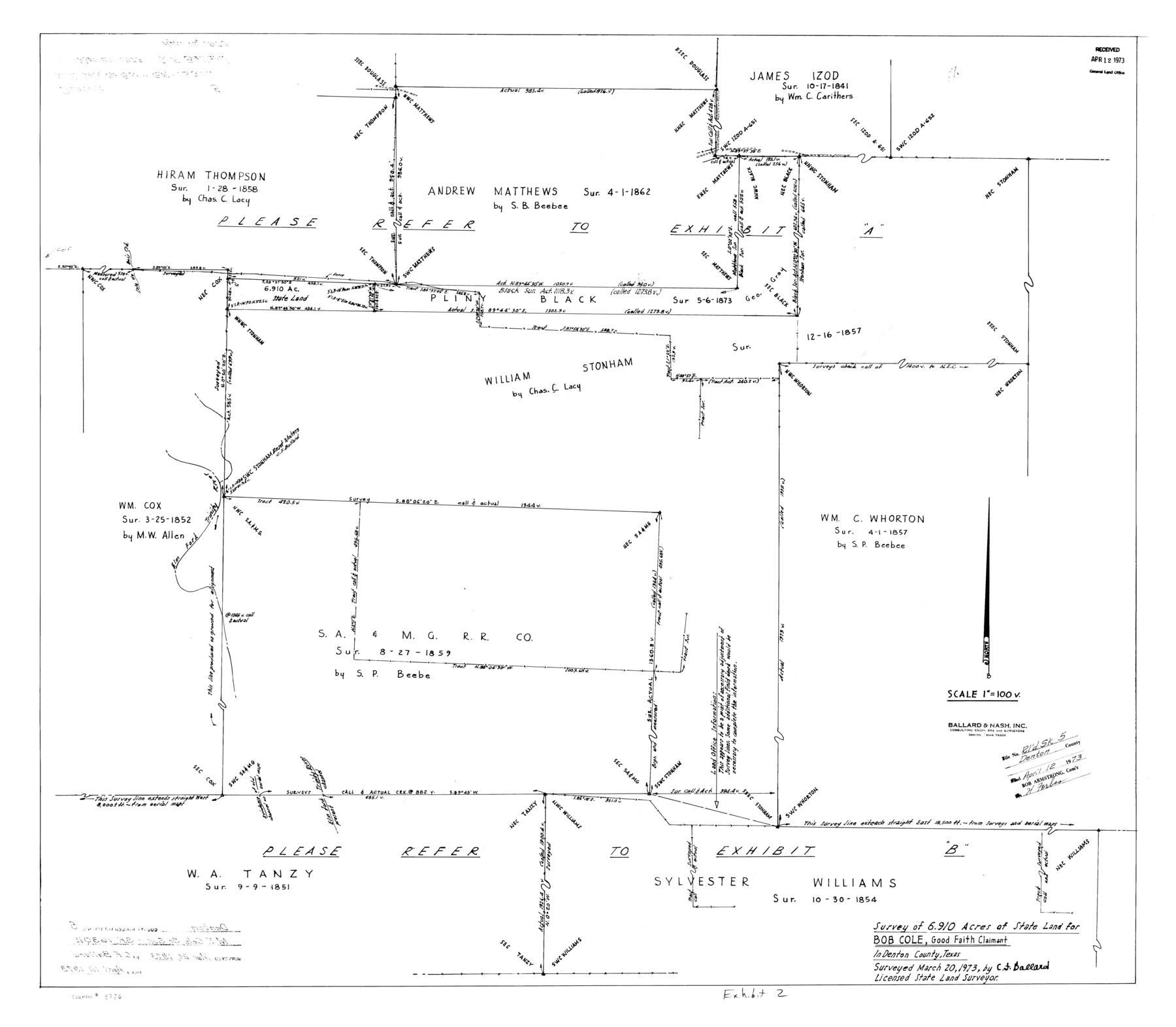
Denton County Rolled Sketch 5
Survey of 6.910 acres of State Land for Bob Cole, Good Faith Claimant
-
Map/Doc
8776
-
Collection
General Map Collection
-
Object Dates
1973/3/20 (Creation Date)
1973/4/12 (File Date)
-
People and Organizations
C.F. Ballard (Surveyor/Engineer)
-
Counties
Denton
-
Subjects
Surveying Rolled Sketch
-
Height x Width
31.9 x 36.6 inches
81.0 x 93.0 cm
-
Scale
1" = 100 varas
-
Comments
See Scrap File 16302.
Part of: General Map Collection
Nueces County Sketch File 17

Print $20.00
- Digital $50.00
Nueces County Sketch File 17
1854
Size 24.8 x 26.6 inches
Map/Doc 42180
Flight Mission No. DQO-8K, Frame 9, Galveston County

Print $20.00
- Digital $50.00
Flight Mission No. DQO-8K, Frame 9, Galveston County
1952
Size 18.7 x 22.5 inches
Map/Doc 85132
Wise County Working Sketch 26

Print $20.00
- Digital $50.00
Wise County Working Sketch 26
1987
Size 25.8 x 33.7 inches
Map/Doc 72640
Newton County Working Sketch 36

Print $20.00
- Digital $50.00
Newton County Working Sketch 36
1960
Size 29.9 x 39.1 inches
Map/Doc 71282
Montgomery Co.

Print $20.00
- Digital $50.00
Montgomery Co.
1840
Size 34.0 x 30.8 inches
Map/Doc 3191
Lamb County Boundary File 2

Print $102.00
- Digital $50.00
Lamb County Boundary File 2
Size 15.4 x 9.1 inches
Map/Doc 56057
Trinity River, Levee Improvement Districts, Widths of Floodways

Print $20.00
- Digital $50.00
Trinity River, Levee Improvement Districts, Widths of Floodways
1920
Size 31.8 x 23.2 inches
Map/Doc 65254
Map of Ramsey State Farm

Print $20.00
- Digital $50.00
Map of Ramsey State Farm
1934
Size 30.3 x 38.0 inches
Map/Doc 94284
Foard County Sketch File 18

Print $6.00
- Digital $50.00
Foard County Sketch File 18
1888
Size 13.0 x 8.5 inches
Map/Doc 22834
Liberty County Sketch File 19

Print $6.00
- Digital $50.00
Liberty County Sketch File 19
1859
Size 13.6 x 9.4 inches
Map/Doc 29923
Flight Mission No. DAG-17K, Frame 129, Matagorda County

Print $20.00
- Digital $50.00
Flight Mission No. DAG-17K, Frame 129, Matagorda County
1952
Size 18.6 x 22.3 inches
Map/Doc 86349
Flight Mission No. BRA-3M, Frame 121, Jefferson County

Print $20.00
- Digital $50.00
Flight Mission No. BRA-3M, Frame 121, Jefferson County
1953
Size 18.8 x 22.3 inches
Map/Doc 85395
You may also like
Brewster County Rolled Sketch 92

Print $20.00
- Digital $50.00
Brewster County Rolled Sketch 92
1950
Size 24.3 x 15.2 inches
Map/Doc 5250
Waller County Boundary File 1

Print $8.00
- Digital $50.00
Waller County Boundary File 1
Size 11.4 x 8.9 inches
Map/Doc 59663
Angelina County Sketch File 22

Print $8.00
- Digital $50.00
Angelina County Sketch File 22
1891
Size 14.0 x 8.7 inches
Map/Doc 13049
[Sketch showing T.&P. Blks. 35, 32, 33, 34, T3N, Blks. 1, 2 and T.T. R.R. Co. Blk. 2]
![89764, [Sketch showing T.&P. Blks. 35, 32, 33, 34, T3N, Blks. 1, 2 and T.T. R.R. Co. Blk. 2], Twichell Survey Records](https://historictexasmaps.com/wmedia_w700/maps/89764-1.tif.jpg)
Print $40.00
- Digital $50.00
[Sketch showing T.&P. Blks. 35, 32, 33, 34, T3N, Blks. 1, 2 and T.T. R.R. Co. Blk. 2]
Size 54.8 x 47.4 inches
Map/Doc 89764
Jefferson County NRC Article 33.136 Location Key Sheet

Print $20.00
- Digital $50.00
Jefferson County NRC Article 33.136 Location Key Sheet
1993
Size 27.0 x 21.8 inches
Map/Doc 77030
Kendall County Boundary File 54

Print $16.00
- Digital $50.00
Kendall County Boundary File 54
Size 8.6 x 3.5 inches
Map/Doc 55769
Partial View of Austin, Texas

Print $20.00
Partial View of Austin, Texas
1895
Size 28.4 x 41.8 inches
Map/Doc 76205
DeWitt County Boundary File 1

Print $74.00
- Digital $50.00
DeWitt County Boundary File 1
Size 23.4 x 14.9 inches
Map/Doc 52479
Tom Green County Rolled Sketch 29

Print $20.00
- Digital $50.00
Tom Green County Rolled Sketch 29
Size 17.8 x 23.4 inches
Map/Doc 93646
Austin including Bergstrom AFB, Hays, Mansfield Dam, McKinney Falls State Park, Oak Hill, Rollingwood, San Leanna, Sunset Valley and West Lake Hills - also portions of Pflugerville

Austin including Bergstrom AFB, Hays, Mansfield Dam, McKinney Falls State Park, Oak Hill, Rollingwood, San Leanna, Sunset Valley and West Lake Hills - also portions of Pflugerville
Size 38.5 x 25.6 inches
Map/Doc 94376
Hudspeth County Working Sketch 32

Print $20.00
- Digital $50.00
Hudspeth County Working Sketch 32
1972
Size 21.6 x 31.7 inches
Map/Doc 66316
Culberson County Rolled Sketch 21

Print $20.00
- Digital $50.00
Culberson County Rolled Sketch 21
1915
Size 31.2 x 15.6 inches
Map/Doc 5654