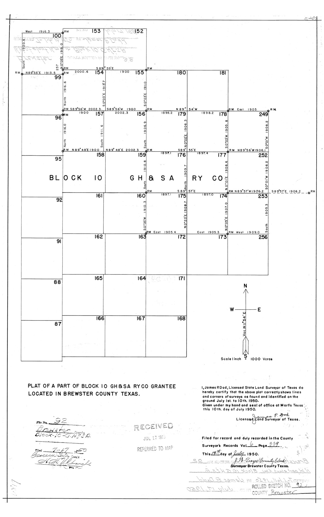
Brewster County Rolled Sketch 92
Plat of a part of Block 10, G. H. & S. A. Ry. Co. grantee located in Brewster County, Texas
-
Map/Doc
5250
-
Collection
General Map Collection
-
Object Dates
1950/7/10 (Creation Date)
1950/7/17 (File Date)
-
People and Organizations
James P. Dod (Surveyor/Engineer)
-
Counties
Brewster
-
Subjects
Surveying Rolled Sketch
-
Height x Width
24.3 x 15.2 inches
61.7 x 38.6 cm
-
Scale
1" = 1000 varas
Part of: General Map Collection
Duval County Sketch File 16

Print $6.00
- Digital $50.00
Duval County Sketch File 16
1875
Size 7.4 x 8.2 inches
Map/Doc 21311
Bexar County Rolled Sketch 16

Print $20.00
- Digital $50.00
Bexar County Rolled Sketch 16
1847
Size 21.1 x 14.8 inches
Map/Doc 5141
Baylor County

Print $40.00
- Digital $50.00
Baylor County
1917
Size 48.1 x 40.2 inches
Map/Doc 66714
Runnels County Sketch File E

Print $6.00
Runnels County Sketch File E
1895
Size 12.7 x 8.3 inches
Map/Doc 35481
Surveyor's Watercourse Report 2

Print $42.00
Surveyor's Watercourse Report 2
2025
Size 11.0 x 8.5 inches
Map/Doc 97512
Pecos County Working Sketch 69

Print $40.00
- Digital $50.00
Pecos County Working Sketch 69
1956
Size 48.7 x 32.6 inches
Map/Doc 71541
Taylor County Sketch File 22

Print $189.00
- Digital $50.00
Taylor County Sketch File 22
1985
Size 14.6 x 8.9 inches
Map/Doc 37826
Maverick County Working Sketch 8

Print $40.00
- Digital $50.00
Maverick County Working Sketch 8
1959
Size 50.3 x 37.7 inches
Map/Doc 70900
Fisher County Sketch File 10

Print $20.00
- Digital $50.00
Fisher County Sketch File 10
Size 9.7 x 37.0 inches
Map/Doc 11477

Hopkins County Rolled Sketch 28

Print $20.00
- Digital $50.00
Hopkins County Rolled Sketch 28
Size 25.3 x 19.9 inches
Map/Doc 6225
Parker County Sketch File 32

Print $6.00
- Digital $50.00
Parker County Sketch File 32
Size 11.0 x 12.2 inches
Map/Doc 33574
You may also like
Matagorda County NRC Article 33.136 Sketch 23

Print $76.00
Matagorda County NRC Article 33.136 Sketch 23
2025
Map/Doc 97502
Cottle County Working Sketch 15

Print $40.00
- Digital $50.00
Cottle County Working Sketch 15
1965
Size 31.8 x 58.3 inches
Map/Doc 68325
Webb County Working Sketch 65

Print $40.00
- Digital $50.00
Webb County Working Sketch 65
1964
Size 49.0 x 59.5 inches
Map/Doc 72431
Edwards County

Print $20.00
- Digital $50.00
Edwards County
1893
Size 30.8 x 33.1 inches
Map/Doc 3507
Armstrong County Sketch File A-5

Print $40.00
- Digital $50.00
Armstrong County Sketch File A-5
1918
Size 18.0 x 28.2 inches
Map/Doc 10846
[Capitol and School Lands in Lamb County]
![91068, [Capitol and School Lands in Lamb County], Twichell Survey Records](https://historictexasmaps.com/wmedia_w700/maps/91068-1.tif.jpg)
Print $20.00
- Digital $50.00
[Capitol and School Lands in Lamb County]
Size 19.2 x 20.5 inches
Map/Doc 91068
Angelina County Sketch File 11d

Print $6.00
- Digital $50.00
Angelina County Sketch File 11d
1885
Size 12.7 x 8.3 inches
Map/Doc 12948
Ward County Working Sketch 4

Print $20.00
- Digital $50.00
Ward County Working Sketch 4
1943
Size 17.0 x 16.7 inches
Map/Doc 72310
[Block Y2 and Part of Block 1, B. & B.]
![91169, [Block Y2 and Part of Block 1, B. & B.], Twichell Survey Records](https://historictexasmaps.com/wmedia_w700/maps/91169-1.tif.jpg)
Print $20.00
- Digital $50.00
[Block Y2 and Part of Block 1, B. & B.]
Size 26.2 x 17.6 inches
Map/Doc 91169
Pecos County Working Sketch 27

Print $40.00
- Digital $50.00
Pecos County Working Sketch 27
1929
Size 36.9 x 50.8 inches
Map/Doc 71498
Val Verde County Working Sketch 2

Print $20.00
- Digital $50.00
Val Verde County Working Sketch 2
Size 27.9 x 23.8 inches
Map/Doc 72137
