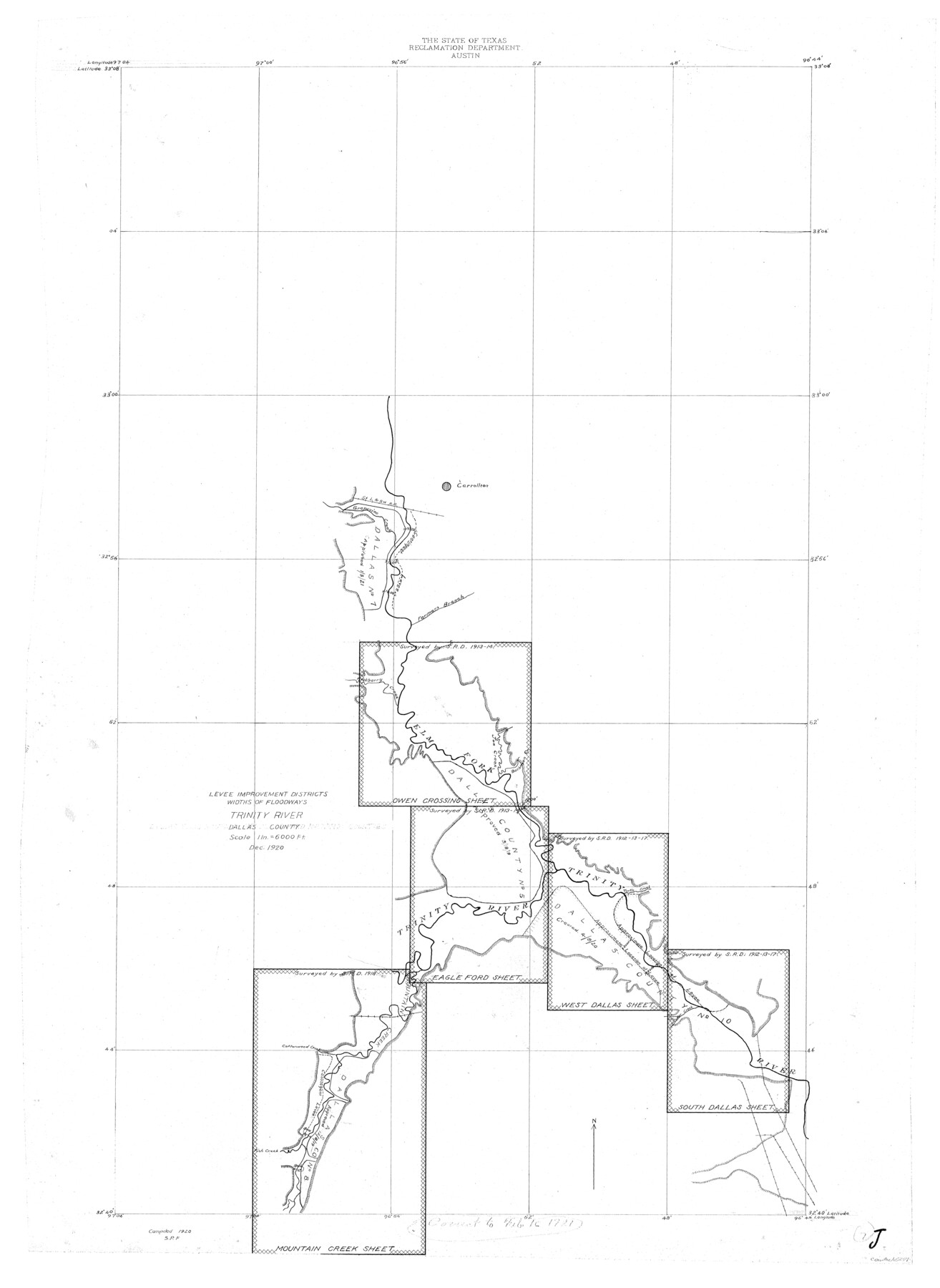
Trinity River, Levee Improvement Districts, Widths of Floodways
-
Map/Doc
65254
-
Collection
General Map Collection
-
Object Dates
1920 (Creation Date)
-
People and Organizations
Texas State Reclamation Department (Publisher)
S.P. Floore (Compiler)
S.P. Floore (Draftsman)
-
Counties
Dallas
-
Subjects
River Surveys Topographic
-
Height x Width
31.8 x 23.2 inches
80.8 x 58.9 cm
-
Comments
Sheet composed of the following sheets: Owen Crossing, Eagle Ford, Mountain Creek, West Dallas and South Dallas.
Part of: General Map Collection
Hartley County Sketch File 17

Print $4.00
- Digital $50.00
Hartley County Sketch File 17
1892
Size 11.2 x 8.9 inches
Map/Doc 26115
Dallas County Working Sketch 3

Print $20.00
- Digital $50.00
Dallas County Working Sketch 3
1922
Size 14.2 x 12.2 inches
Map/Doc 68569
Castro County Sketch File 16

Print $4.00
- Digital $50.00
Castro County Sketch File 16
1891
Size 11.0 x 8.8 inches
Map/Doc 17513
Roberts County Working Sketch 43

Print $20.00
- Digital $50.00
Roberts County Working Sketch 43
1990
Size 19.3 x 37.6 inches
Map/Doc 63569
Shelby County Sketch File 33

Print $8.00
- Digital $50.00
Shelby County Sketch File 33
1949
Size 11.5 x 9.0 inches
Map/Doc 36670
Denton County Sketch File 7

Print $8.00
- Digital $50.00
Denton County Sketch File 7
Size 13.7 x 7.9 inches
Map/Doc 20698
Flight Mission No. CRC-3R, Frame 199, Chambers County

Print $20.00
- Digital $50.00
Flight Mission No. CRC-3R, Frame 199, Chambers County
1956
Size 18.5 x 22.3 inches
Map/Doc 84854
Clay County Rolled Sketch 4A

Print $20.00
- Digital $50.00
Clay County Rolled Sketch 4A
1949
Size 22.0 x 24.0 inches
Map/Doc 5498
Irion County Sketch File 2

Print $22.00
- Digital $50.00
Irion County Sketch File 2
1890
Size 11.2 x 8.4 inches
Map/Doc 27456
[Galveston, Harrisburg & San Antonio through El Paso County]
![64013, [Galveston, Harrisburg & San Antonio through El Paso County], General Map Collection](https://historictexasmaps.com/wmedia_w700/maps/64013.tif.jpg)
Print $20.00
- Digital $50.00
[Galveston, Harrisburg & San Antonio through El Paso County]
1906
Size 13.5 x 33.5 inches
Map/Doc 64013
Fannin County Sketch File 9a

Print $4.00
- Digital $50.00
Fannin County Sketch File 9a
Size 8.2 x 6.4 inches
Map/Doc 22455
Llano County Sketch File 18

Print $20.00
- Digital $50.00
Llano County Sketch File 18
1949
Size 22.3 x 20.0 inches
Map/Doc 12013
You may also like
Carta Esferica que comprehende las costas del Seno Mexicano construida de orden del rey en el deposito hidrografico de marina: Por disposicion del Exmo. Señor Don Juan de Langara, Secretario de Estado y del Despacho Universal de ella. Año de 1799.

Print $20.00
- Digital $50.00
Carta Esferica que comprehende las costas del Seno Mexicano construida de orden del rey en el deposito hidrografico de marina: Por disposicion del Exmo. Señor Don Juan de Langara, Secretario de Estado y del Despacho Universal de ella. Año de 1799.
1799
Size 25.9 x 37.3 inches
Map/Doc 95367
Louisiana and Texas Intracoastal Waterway

Print $20.00
- Digital $50.00
Louisiana and Texas Intracoastal Waterway
1937
Size 13.7 x 19.6 inches
Map/Doc 83348

Gray's railroad map of Texas.

Print $20.00
Gray's railroad map of Texas.
1878
Size 26.4 x 16.1 inches
Map/Doc 93597
Comanche County

Print $20.00
- Digital $50.00
Comanche County
1896
Size 40.5 x 45.1 inches
Map/Doc 66783
Travis County Appraisal District Plat Map 2_0603

Print $20.00
- Digital $50.00
Travis County Appraisal District Plat Map 2_0603
Size 21.5 x 26.4 inches
Map/Doc 94233
Angelina County Sketch File 7

Print $40.00
- Digital $50.00
Angelina County Sketch File 7
1858
Size 15.5 x 35.8 inches
Map/Doc 10812
Floyd County Sketch File 24

Print $6.00
- Digital $50.00
Floyd County Sketch File 24
1915
Size 9.0 x 14.5 inches
Map/Doc 22780
Map of North America engraved to illustrate Mitchell's school and family geography

Print $20.00
Map of North America engraved to illustrate Mitchell's school and family geography
1839
Size 11.3 x 8.7 inches
Map/Doc 93552
Milam County Working Sketch 8

Print $20.00
- Digital $50.00
Milam County Working Sketch 8
1970
Size 27.1 x 30.7 inches
Map/Doc 71023
[Sketch showing PSL Block AX and C. C. S. D. & R. G. N. G. RR. Co. Block G]
![90912, [Sketch showing PSL Block AX and C. C. S. D. & R. G. N. G. RR. Co. Block G], Twichell Survey Records](https://historictexasmaps.com/wmedia_w700/maps/90912-1.tif.jpg)
Print $20.00
- Digital $50.00
[Sketch showing PSL Block AX and C. C. S. D. & R. G. N. G. RR. Co. Block G]
Size 26.2 x 16.4 inches
Map/Doc 90912
Irion County Sketch File 11

Print $20.00
- Digital $50.00
Irion County Sketch File 11
1937
Size 22.2 x 17.5 inches
Map/Doc 11826