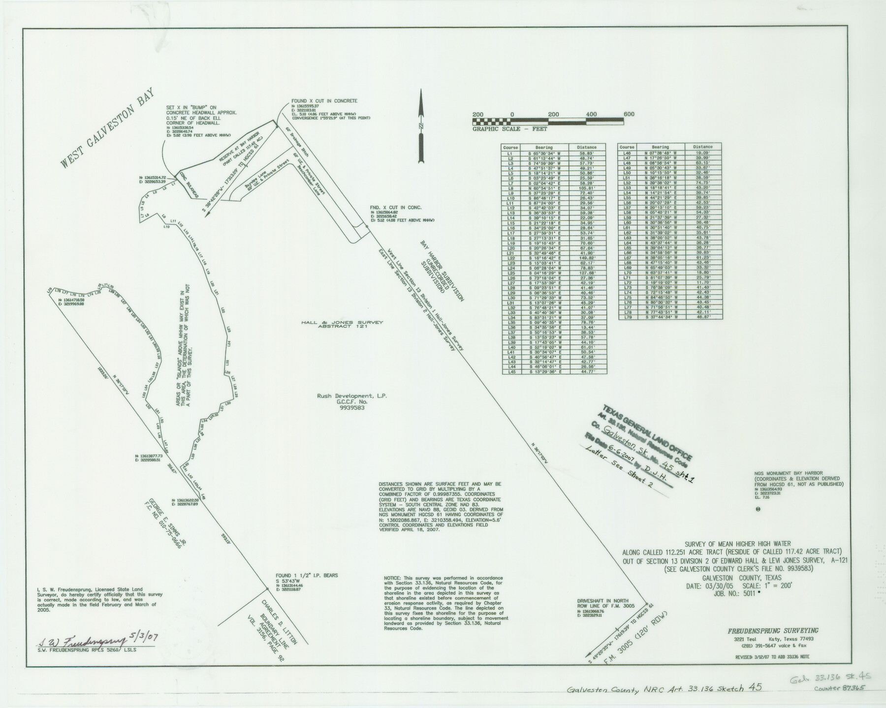
Galveston County NRC Article 33.136 Sketch 45
A Survey of Mean Higher High Water Along Called 112.251 Acre Tract Out of Section 13 Division 2 of Edward Hall and Levi Jones Survey, A-121
-
Map/Doc
87365
-
Collection
General Map Collection
-
Object Dates
2007/3/12 (Creation Date)
2007/6/6 (File Date)
-
People and Organizations
Freudensprung Surveying (Publisher)
Freudensprung Surveying (Printer)
Sandy Freudensprung (Surveyor/Engineer)
-
Counties
Galveston
-
Subjects
Surveying CBS
-
Height x Width
18.7 x 23.4 inches
47.5 x 59.4 cm
-
Medium
multi-page, multi-format
-
Comments
Survey located about 21 miles South 56 degrees West of Galveston, Texas.
Part of: General Map Collection
Jim Hogg County Sketch File 2

Print $20.00
- Digital $50.00
Jim Hogg County Sketch File 2
1926
Size 24.9 x 17.7 inches
Map/Doc 11884
Limestone County Sketch File 20

Print $44.00
- Digital $50.00
Limestone County Sketch File 20
1922
Size 11.2 x 8.5 inches
Map/Doc 30195
Kinney County Sketch File 14

Print $6.00
- Digital $50.00
Kinney County Sketch File 14
1886
Size 10.9 x 16.6 inches
Map/Doc 29131
Presidio County Sketch File 105

Print $40.00
- Digital $50.00
Presidio County Sketch File 105
Size 15.6 x 59.1 inches
Map/Doc 82963
Angelina County Sketch File 28

Print $22.00
- Digital $50.00
Angelina County Sketch File 28
1910
Size 15.7 x 12.0 inches
Map/Doc 13078
Sutton County Rolled Sketch 70

Print $40.00
- Digital $50.00
Sutton County Rolled Sketch 70
Size 48.7 x 37.0 inches
Map/Doc 9982
Mills County Sketch File 28

Print $8.00
- Digital $50.00
Mills County Sketch File 28
2000
Size 14.3 x 8.7 inches
Map/Doc 31684
San Augustine Co.

Print $40.00
- Digital $50.00
San Augustine Co.
1949
Size 48.9 x 32.2 inches
Map/Doc 95632
Denton County Sketch File 37

Print $24.00
- Digital $50.00
Denton County Sketch File 37
1932
Size 11.5 x 8.9 inches
Map/Doc 20776
Montague County Working Sketch 34

Print $20.00
- Digital $50.00
Montague County Working Sketch 34
1979
Size 20.3 x 15.0 inches
Map/Doc 71100
Bailey County Sketch File 15

Print $18.00
- Digital $50.00
Bailey County Sketch File 15
1912
Size 8.7 x 11.2 inches
Map/Doc 13975
Runnels County Sketch File 3

Print $4.00
Runnels County Sketch File 3
1871
Size 13.0 x 8.1 inches
Map/Doc 35432
You may also like
Map of Main Line Houston & Tex. Centr. Railway from Dallas to Red River City

Print $40.00
- Digital $50.00
Map of Main Line Houston & Tex. Centr. Railway from Dallas to Red River City
Size 37.1 x 84.9 inches
Map/Doc 64089
Gaines County Working Sketch 1

Print $40.00
- Digital $50.00
Gaines County Working Sketch 1
1937
Size 22.7 x 53.1 inches
Map/Doc 69301
Galveston Harbor and Channel, Texas - Rehabilitation of Beachfront Groins - Present Construction

Print $4.00
- Digital $50.00
Galveston Harbor and Channel, Texas - Rehabilitation of Beachfront Groins - Present Construction
1967
Size 15.6 x 21.0 inches
Map/Doc 73619
La Salle County Rolled Sketch 16

Print $20.00
- Digital $50.00
La Salle County Rolled Sketch 16
1948
Size 26.7 x 20.9 inches
Map/Doc 6580
Ellis County Boundary File 5

Print $4.00
- Digital $50.00
Ellis County Boundary File 5
Size 11.5 x 7.2 inches
Map/Doc 52990
Refugio County Working Sketch 10

Print $20.00
- Digital $50.00
Refugio County Working Sketch 10
1941
Size 43.0 x 30.1 inches
Map/Doc 63519
Fort Bend County Working Sketch 21

Print $20.00
- Digital $50.00
Fort Bend County Working Sketch 21
Size 26.9 x 28.6 inches
Map/Doc 69227
Flight Mission No. DQO-2K, Frame 139, Galveston County

Print $20.00
- Digital $50.00
Flight Mission No. DQO-2K, Frame 139, Galveston County
1952
Size 18.8 x 22.5 inches
Map/Doc 85036
Ector County Rolled Sketch 12

Print $38.00
- Digital $50.00
Ector County Rolled Sketch 12
Size 10.1 x 15.4 inches
Map/Doc 44314
Jones County Working Sketch 7

Print $20.00
- Digital $50.00
Jones County Working Sketch 7
1957
Size 30.8 x 12.7 inches
Map/Doc 66645
The United States of Mexico

Print $20.00
- Digital $50.00
The United States of Mexico
1832
Size 15.4 x 12.8 inches
Map/Doc 93952
El Paso County Sketch File 33

Print $2.00
- Digital $50.00
El Paso County Sketch File 33
1983
Size 9.0 x 14.5 inches
Map/Doc 22128