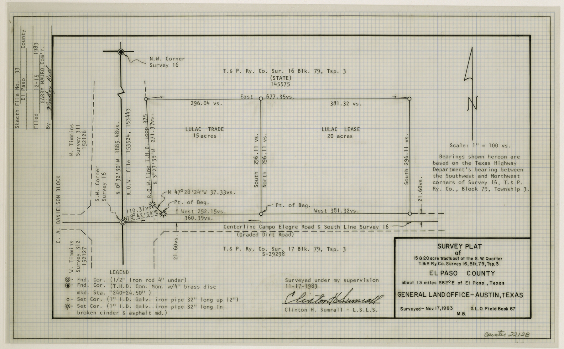
El Paso County Sketch File 33
Survey plat of 15 and 20 acre tracts out of the southwest quarter T. & P. RR. Co. Survey 16, Block 79, Township 3
-
Map/Doc
22128
-
Collection
General Map Collection
-
Object Dates
1983/11/11 (Creation Date)
1983/12/20 (File Date)
1983/11/17 (Survey Date)
-
People and Organizations
Clinton H. Sumrall (Surveyor/Engineer)
-
Counties
El Paso
-
Subjects
Surveying Sketch File
-
Height x Width
9.0 x 14.5 inches
22.9 x 36.8 cm
-
Medium
mylar, print
-
Scale
1" = 100 varas
-
Features
Campo Elegre Road
Part of: General Map Collection

Flight Mission No. DQN-1K, Frame 69, Calhoun County

Print $20.00
- Digital $50.00
Flight Mission No. DQN-1K, Frame 69, Calhoun County
1953
Size 18.5 x 22.2 inches
Map/Doc 84156
Orange County Sketch File 13

Print $6.00
- Digital $50.00
Orange County Sketch File 13
1885
Size 11.3 x 9.7 inches
Map/Doc 33326
Brewster County Rolled Sketch 112

Print $20.00
- Digital $50.00
Brewster County Rolled Sketch 112
1962
Size 28.9 x 25.7 inches
Map/Doc 5263
[Sketch for Mineral Application 1487 -Big Wichita River, Ernest R. Smith]
![65684, [Sketch for Mineral Application 1487 -Big Wichita River, Ernest R. Smith], General Map Collection](https://historictexasmaps.com/wmedia_w700/maps/65684.tif.jpg)
Print $40.00
- Digital $50.00
[Sketch for Mineral Application 1487 -Big Wichita River, Ernest R. Smith]
1918
Size 32.2 x 130.1 inches
Map/Doc 65684
Greer County Sketch File 11

Print $6.00
- Digital $50.00
Greer County Sketch File 11
Size 14.2 x 8.8 inches
Map/Doc 24532
City of Port Aransas

Print $40.00
- Digital $50.00
City of Port Aransas
1990
Size 25.2 x 53.3 inches
Map/Doc 3213
Nacogdoches County Rolled Sketch 3

Print $20.00
- Digital $50.00
Nacogdoches County Rolled Sketch 3
1985
Size 39.6 x 27.6 inches
Map/Doc 6837
Montague County Sketch File 15

Print $6.00
- Digital $50.00
Montague County Sketch File 15
1880
Size 11.0 x 15.1 inches
Map/Doc 31742
Calhoun County NRC Article 33.136 Sketch 1

Print $42.00
- Digital $50.00
Calhoun County NRC Article 33.136 Sketch 1
2000
Size 16.8 x 21.7 inches
Map/Doc 61556
Leon County Sketch File 8

Print $4.00
- Digital $50.00
Leon County Sketch File 8
1862
Size 12.8 x 8.3 inches
Map/Doc 29724
Flight Mission No. BRA-16M, Frame 141, Jefferson County

Print $20.00
- Digital $50.00
Flight Mission No. BRA-16M, Frame 141, Jefferson County
1953
Size 18.6 x 22.2 inches
Map/Doc 85747
You may also like
Edwards County Working Sketch 109

Print $40.00
- Digital $50.00
Edwards County Working Sketch 109
1972
Size 51.8 x 37.6 inches
Map/Doc 68985
Presidio County Rolled Sketch 131A

Print $3.00
- Digital $50.00
Presidio County Rolled Sketch 131A
Size 14.5 x 9.1 inches
Map/Doc 10709
Hudspeth County Sketch File 51

Print $4.00
- Digital $50.00
Hudspeth County Sketch File 51
1962
Size 14.4 x 9.1 inches
Map/Doc 27074
Rusk County Sketch File 44

Print $12.00
Rusk County Sketch File 44
1951
Size 11.3 x 8.9 inches
Map/Doc 35585
Clay County Boundary File 9

Print $8.00
- Digital $50.00
Clay County Boundary File 9
Size 7.7 x 8.2 inches
Map/Doc 51393

Fannin County Sketch File 18

Print $20.00
- Digital $50.00
Fannin County Sketch File 18
1879
Size 16.7 x 22.2 inches
Map/Doc 11472
Palo Pinto County

Print $20.00
- Digital $50.00
Palo Pinto County
Size 23.7 x 18.6 inches
Map/Doc 3936
[Section of] El Nuevo Mexico y Tierras Adyacentes Mapa Levantado para la demarcacion de los Limites de los Dominios Españoles y de los Estados Unidos

[Section of] El Nuevo Mexico y Tierras Adyacentes Mapa Levantado para la demarcacion de los Limites de los Dominios Españoles y de los Estados Unidos
1811
Size 17.9 x 26.7 inches
Map/Doc 97484
Aransas County Aerial Photograph Index Sheet 4

Print $20.00
- Digital $50.00
Aransas County Aerial Photograph Index Sheet 4
1957
Size 23.6 x 16.1 inches
Map/Doc 83662
Val Verde County Working Sketch 25

Print $20.00
- Digital $50.00
Val Verde County Working Sketch 25
1934
Size 24.2 x 18.2 inches
Map/Doc 72160
Henderson County Rolled Sketch 11

Print $20.00
- Digital $50.00
Henderson County Rolled Sketch 11
1915
Size 29.5 x 42.6 inches
Map/Doc 75947