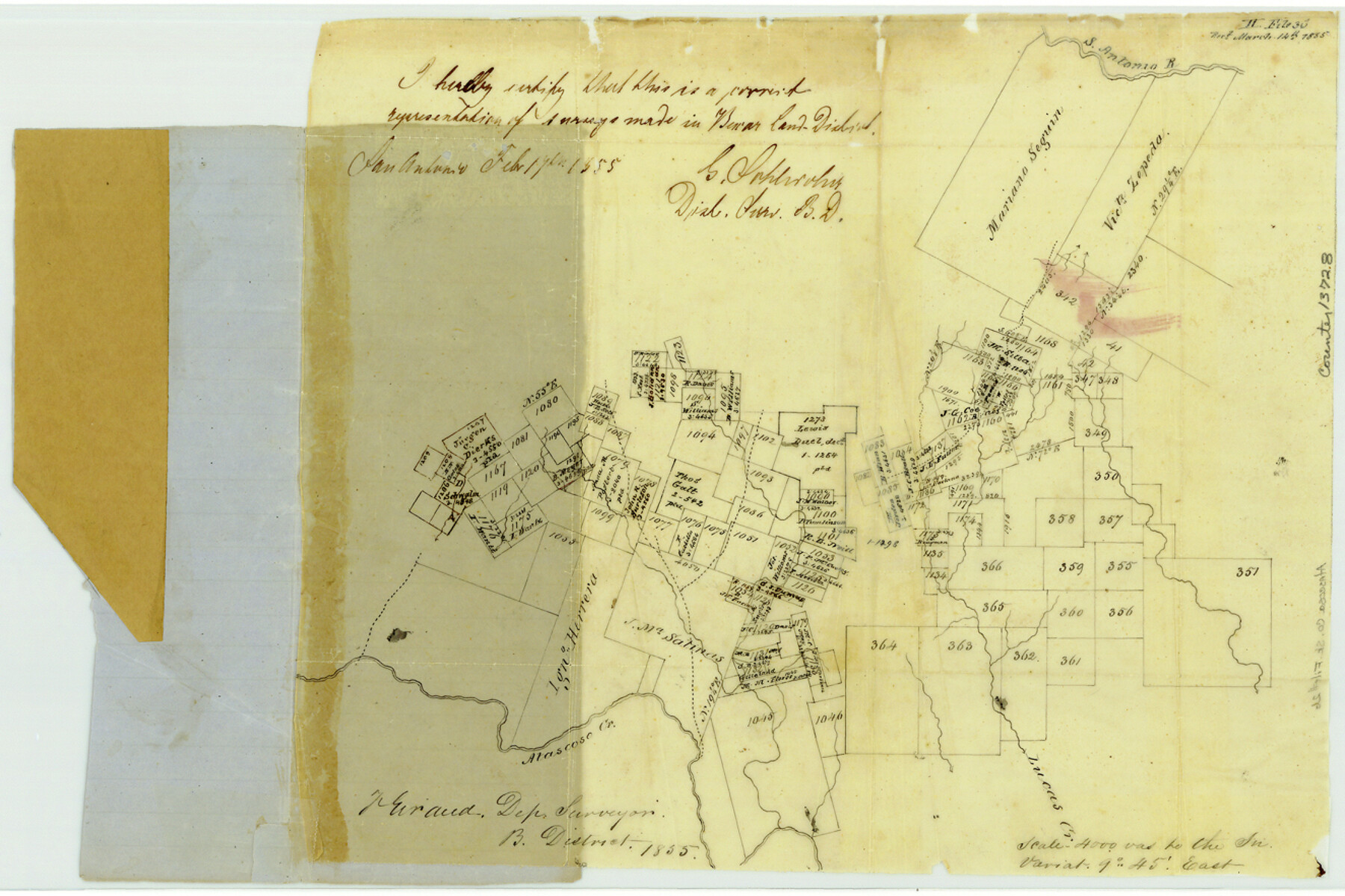
Atascosa County Sketch File 2b
[Sketch of surveys on the Atascosa River at the crossing of the Laredo Road]
-
Map/Doc
13728
-
Collection
General Map Collection
-
Object Dates
1855/2/17 (Creation Date)
1855/3/14 (File Date)
-
People and Organizations
F. Giraud (Surveyor/Engineer)
G. Schleicher (Surveyor/Engineer)
-
Counties
Atascosa
-
Subjects
Surveying Sketch File
-
Height x Width
8.8 x 13.2 inches
22.4 x 33.5 cm
-
Medium
paper, manuscript
-
Scale
1" = 4000 varas
-
Features
San Antonio River
Atascosa Creek
Lucas Creek
Part of: General Map Collection
Burleson County Sketch File 3

Print $4.00
- Digital $50.00
Burleson County Sketch File 3
1848
Size 6.4 x 7.4 inches
Map/Doc 16647
Flight Mission No. CRC-2R, Frame 121, Chambers County

Print $20.00
- Digital $50.00
Flight Mission No. CRC-2R, Frame 121, Chambers County
1956
Size 18.7 x 22.4 inches
Map/Doc 84745
Potter County Boundary File 5a

Print $80.00
- Digital $50.00
Potter County Boundary File 5a
Size 13.0 x 71.0 inches
Map/Doc 58024
Presidio County Working Sketch 82

Print $40.00
- Digital $50.00
Presidio County Working Sketch 82
1967
Size 48.6 x 67.2 inches
Map/Doc 71759
San Patricio County Working Sketch 16

Print $20.00
- Digital $50.00
San Patricio County Working Sketch 16
1952
Size 41.6 x 32.1 inches
Map/Doc 63778
Pecos County Rolled Sketch 25 1/2

Print $20.00
- Digital $50.00
Pecos County Rolled Sketch 25 1/2
1888
Size 41.9 x 39.2 inches
Map/Doc 9688
Zavala County Sketch File 35

Print $4.00
- Digital $50.00
Zavala County Sketch File 35
1887
Size 11.3 x 9.0 inches
Map/Doc 41397
Map of the 1st, 2nd and 3rd Sections of Houston & Texas Central Railroad

Print $40.00
- Digital $50.00
Map of the 1st, 2nd and 3rd Sections of Houston & Texas Central Railroad
Size 30.7 x 64.6 inches
Map/Doc 64478
Garza County Sketch File 6

Print $8.00
- Digital $50.00
Garza County Sketch File 6
1900
Size 14.2 x 8.7 inches
Map/Doc 24056
Refugio County Sketch File 24

Print $12.00
- Digital $50.00
Refugio County Sketch File 24
1954
Size 14.4 x 8.9 inches
Map/Doc 35283
Hardin County Working Sketch 40

Print $20.00
- Digital $50.00
Hardin County Working Sketch 40
1988
Size 23.0 x 14.4 inches
Map/Doc 63439

You may also like
Bee County Working Sketch 10

Print $20.00
- Digital $50.00
Bee County Working Sketch 10
1941
Size 41.2 x 20.4 inches
Map/Doc 67260
Galveston County Rolled Sketch 46A

Print $20.00
- Digital $50.00
Galveston County Rolled Sketch 46A
2000
Size 24.9 x 37.6 inches
Map/Doc 5982
Flight Mission No. BRE-1P, Frame 105, Nueces County

Print $20.00
- Digital $50.00
Flight Mission No. BRE-1P, Frame 105, Nueces County
1956
Size 18.4 x 22.2 inches
Map/Doc 86676
Hudspeth County Working Sketch 49

Print $20.00
- Digital $50.00
Hudspeth County Working Sketch 49
1984
Size 29.8 x 28.1 inches
Map/Doc 66334
The Republic County of Robertson. Created, December 14, 1837

Print $20.00
The Republic County of Robertson. Created, December 14, 1837
2020
Size 18.9 x 21.6 inches
Map/Doc 96259
McLennan County School Land Leagues 3 & 4

Print $20.00
- Digital $50.00
McLennan County School Land Leagues 3 & 4
Size 10.7 x 18.2 inches
Map/Doc 90930

History of Texas from its First Settlement in 1685 to its Annexation to the United States in 1846 (Vol. 2)

History of Texas from its First Settlement in 1685 to its Annexation to the United States in 1846 (Vol. 2)
1856
Map/Doc 97391
Wilbarger County Working Sketch 13

Print $20.00
- Digital $50.00
Wilbarger County Working Sketch 13
1954
Size 25.9 x 24.0 inches
Map/Doc 72551
Gaines County Working Sketch 11

Print $40.00
- Digital $50.00
Gaines County Working Sketch 11
1953
Size 68.4 x 33.4 inches
Map/Doc 69311
General Highway Map Lynn County

Print $20.00
- Digital $50.00
General Highway Map Lynn County
1949
Size 25.8 x 18.8 inches
Map/Doc 92901
Sheet 6 copied from Champlin Book 5 [Strip Map showing T. & P. connecting lines]
![93175, Sheet 6 copied from Champlin Book 5 [Strip Map showing T. & P. connecting lines], Twichell Survey Records](https://historictexasmaps.com/wmedia_w700/maps/93175-1.tif.jpg)
Print $40.00
- Digital $50.00
Sheet 6 copied from Champlin Book 5 [Strip Map showing T. & P. connecting lines]
1909
Size 7.7 x 90.0 inches
Map/Doc 93175