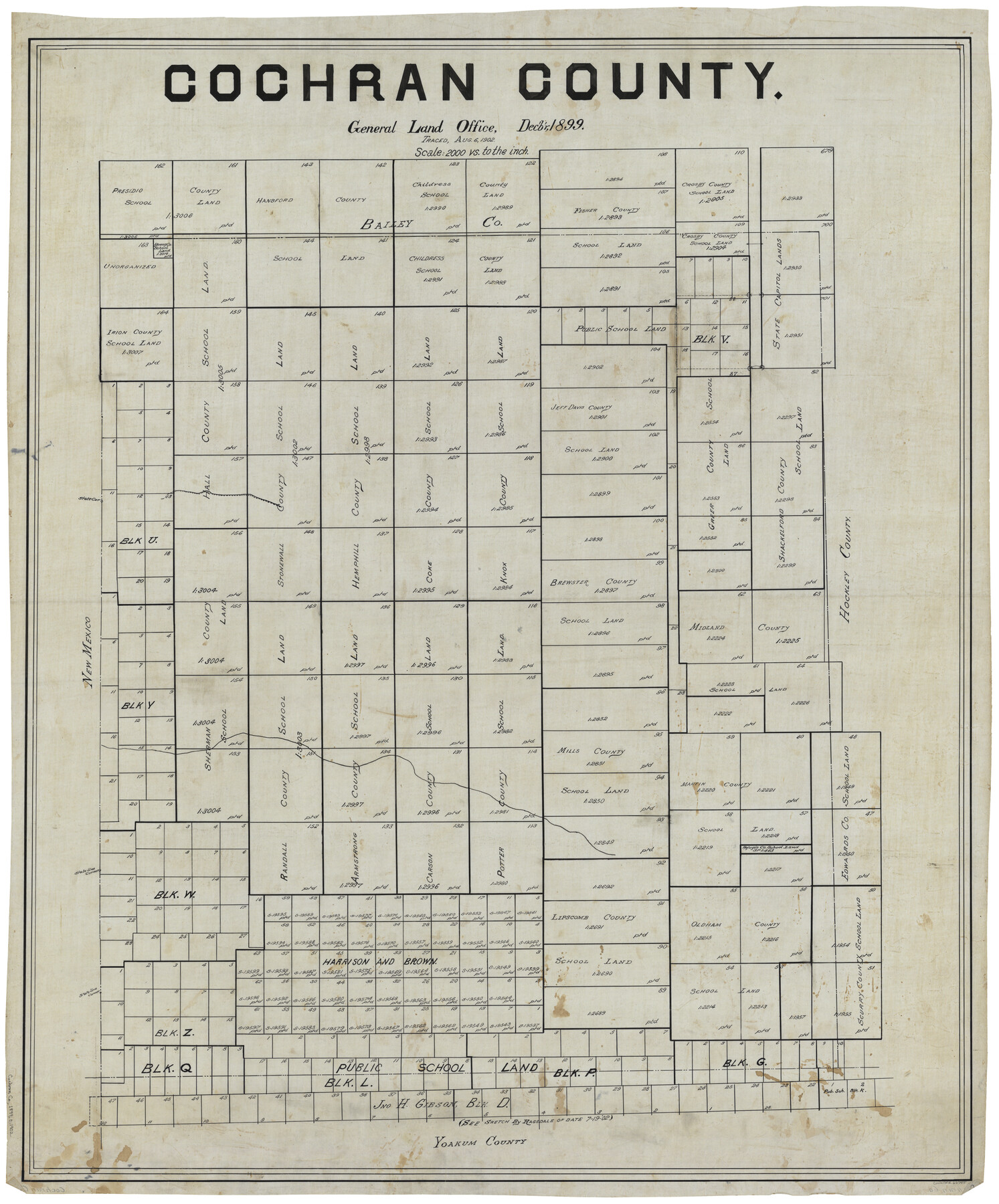
Cochran County
-
Map/Doc
66755
-
Collection
General Map Collection
-
Object Dates
12/1899 (Creation Date)
-
People and Organizations
Texas General Land Office (Publisher)
-
Counties
Cochran
-
Subjects
County
-
Height x Width
41.1 x 34.1 inches
104.4 x 86.6 cm
-
Comments
Traced August 6, 1902.
Part of: General Map Collection
Map of Menard County Texas

Print $20.00
- Digital $50.00
Map of Menard County Texas
1894
Size 33.0 x 42.5 inches
Map/Doc 66927
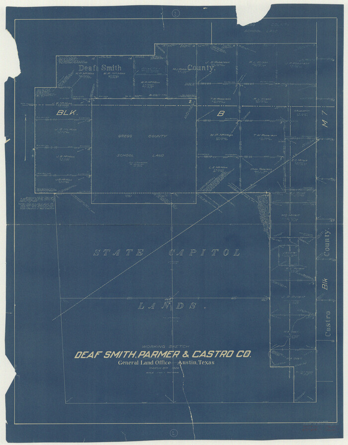
Deaf Smith County Working Sketch 2
Print $20.00
- Digital $50.00
Deaf Smith County Working Sketch 2
1926
Size 42.3 x 33.1 inches
Map/Doc 68642
Harris County Working Sketch 8

Print $20.00
- Digital $50.00
Harris County Working Sketch 8
1904
Size 26.8 x 23.3 inches
Map/Doc 65900
Galveston County Sketch File 66

Print $116.00
- Digital $50.00
Galveston County Sketch File 66
Size 5.0 x 10.0 inches
Map/Doc 23751
Jeff Davis County Working Sketch 34

Print $20.00
- Digital $50.00
Jeff Davis County Working Sketch 34
1978
Size 20.4 x 38.0 inches
Map/Doc 66529
Bandera County Sketch File 32

Print $52.00
- Digital $50.00
Bandera County Sketch File 32
1966
Size 23.6 x 20.0 inches
Map/Doc 10901
Brewster County Rolled Sketch 101

Print $20.00
- Digital $50.00
Brewster County Rolled Sketch 101
1944
Size 34.6 x 42.4 inches
Map/Doc 8924
Sutton County Rolled Sketch 60

Print $20.00
- Digital $50.00
Sutton County Rolled Sketch 60
1964
Size 23.5 x 34.7 inches
Map/Doc 7897
Foard County Sketch File 34

Print $20.00
- Digital $50.00
Foard County Sketch File 34
1889
Size 29.1 x 24.9 inches
Map/Doc 11497
Brewster County Rolled Sketch 22B

Print $20.00
- Digital $50.00
Brewster County Rolled Sketch 22B
1910
Size 24.5 x 19.5 inches
Map/Doc 5203
Lubbock County

Print $20.00
- Digital $50.00
Lubbock County
1879
Size 23.8 x 21.7 inches
Map/Doc 3829
Val Verde County Working Sketch 12

Print $20.00
- Digital $50.00
Val Verde County Working Sketch 12
1920
Size 29.0 x 24.3 inches
Map/Doc 72147
You may also like
Val Verde County Working Sketch Graphic Index, Sheet 1 (Sketches 1 to 25)

Print $20.00
- Digital $50.00
Val Verde County Working Sketch Graphic Index, Sheet 1 (Sketches 1 to 25)
1944
Size 40.4 x 36.5 inches
Map/Doc 76724
Dallas County Sketch File 22

Print $6.00
- Digital $50.00
Dallas County Sketch File 22
1891
Size 9.5 x 10.9 inches
Map/Doc 20454
Floyd County Boundary File 4a

Print $40.00
- Digital $50.00
Floyd County Boundary File 4a
Size 12.2 x 35.8 inches
Map/Doc 53496
Travis County Sketch File 61

Print $8.00
- Digital $50.00
Travis County Sketch File 61
1948
Size 14.4 x 8.8 inches
Map/Doc 38427
Tyler County Sketch File 14

Print $4.00
- Digital $50.00
Tyler County Sketch File 14
1857
Size 8.3 x 10.1 inches
Map/Doc 38656
Wise County Working Sketch 2

Print $20.00
- Digital $50.00
Wise County Working Sketch 2
1940
Size 30.1 x 41.9 inches
Map/Doc 72616
Flight Mission No. CRK-5P, Frame 162, Refugio County

Print $20.00
- Digital $50.00
Flight Mission No. CRK-5P, Frame 162, Refugio County
1956
Size 18.5 x 22.3 inches
Map/Doc 86943
[I. & G. N. Block 1, Secs. 65-75]
![90307, [I. & G. N. Block 1, Secs. 65-75], Twichell Survey Records](https://historictexasmaps.com/wmedia_w700/maps/90307-1.tif.jpg)
Print $20.00
- Digital $50.00
[I. & G. N. Block 1, Secs. 65-75]
1928
Size 22.0 x 18.0 inches
Map/Doc 90307
[Sketch showing part of Blk. M6]
![89642, [Sketch showing part of Blk. M6], Twichell Survey Records](https://historictexasmaps.com/wmedia_w700/maps/89642-1.tif.jpg)
Print $40.00
- Digital $50.00
[Sketch showing part of Blk. M6]
1913
Size 64.8 x 30.3 inches
Map/Doc 89642
McCulloch County Working Sketch 14

Print $20.00
- Digital $50.00
McCulloch County Working Sketch 14
1990
Size 15.3 x 29.0 inches
Map/Doc 70689
[G. C. & S. F. Ry. Northern-Division, Alignment and Right of Way Map, Weatherford Branch, Johnson and Hood Counties, Texas]
![64648, [G. C. & S. F. Ry. Northern-Division, Alignment and Right of Way Map, Weatherford Branch, Johnson and Hood Counties, Texas], General Map Collection](https://historictexasmaps.com/wmedia_w700/maps/64648.tif.jpg)
Print $40.00
- Digital $50.00
[G. C. & S. F. Ry. Northern-Division, Alignment and Right of Way Map, Weatherford Branch, Johnson and Hood Counties, Texas]
1935
Size 37.4 x 120.9 inches
Map/Doc 64648
