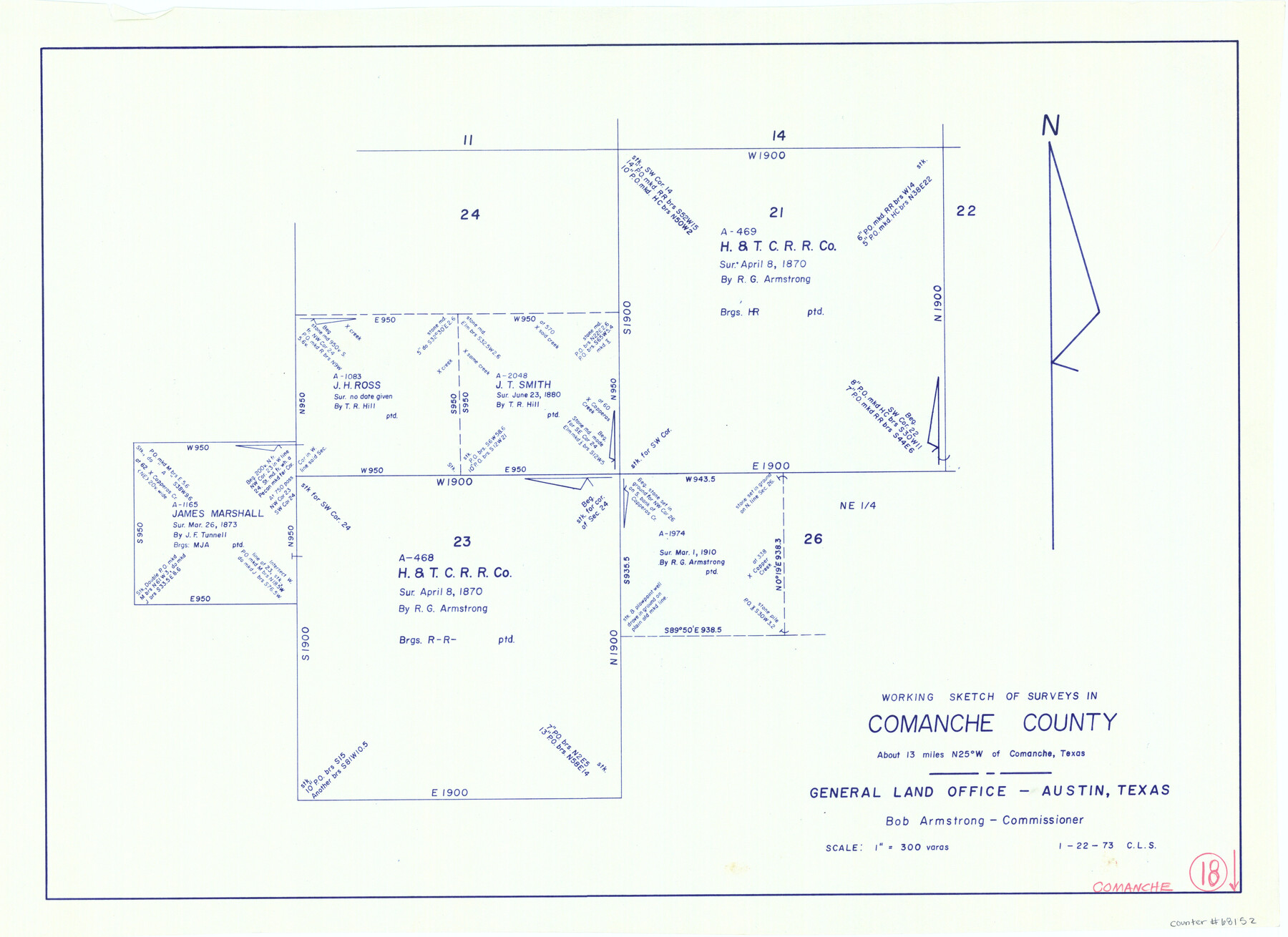
Comanche County Working Sketch 18
-
Map/Doc
68152
-
Collection
General Map Collection
-
Object Dates
1/22/1973 (Creation Date)
-
Counties
Comanche
-
Subjects
Surveying Working Sketch
-
Height x Width
18.3 x 25.2 inches
46.5 x 64.0 cm
-
Scale
1" = 300 varas
Part of: General Map Collection
Flight Mission No. BRE-1P, Frame 96, Nueces County

Print $20.00
- Digital $50.00
Flight Mission No. BRE-1P, Frame 96, Nueces County
1956
Size 18.5 x 22.2 inches
Map/Doc 86667
Smith County Working Sketch 16

Print $20.00
- Digital $50.00
Smith County Working Sketch 16
1988
Size 33.6 x 44.9 inches
Map/Doc 63901
Copy of a chart of Aransas and Corpus Christi Bays by an inhabitant of St. Joseph's Island, the main features of which have been verified by the actual examination of myself & other officers of the Army

Print $20.00
- Digital $50.00
Copy of a chart of Aransas and Corpus Christi Bays by an inhabitant of St. Joseph's Island, the main features of which have been verified by the actual examination of myself & other officers of the Army
1846
Size 26.6 x 18.3 inches
Map/Doc 72972
Map of Part of Texas Prison System, Blue Ridge State Farm, Fort Bend and Harris Counties

Print $20.00
- Digital $50.00
Map of Part of Texas Prison System, Blue Ridge State Farm, Fort Bend and Harris Counties
Size 24.1 x 26.3 inches
Map/Doc 62981
Armstrong County Rolled Sketch 4

Print $40.00
- Digital $50.00
Armstrong County Rolled Sketch 4
1876
Size 37.8 x 70.8 inches
Map/Doc 8426
Bandera County Sketch File 22

Print $4.00
- Digital $50.00
Bandera County Sketch File 22
Size 12.6 x 7.9 inches
Map/Doc 14012
Brazoria County Working Sketch 25

Print $20.00
- Digital $50.00
Brazoria County Working Sketch 25
1964
Size 31.2 x 44.4 inches
Map/Doc 67510
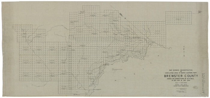
Brewster County Rolled Sketch 121
Print $40.00
- Digital $50.00
Brewster County Rolled Sketch 121
1942
Size 43.3 x 92.8 inches
Map/Doc 93790
Jefferson County Rolled Sketch 36

Print $20.00
- Digital $50.00
Jefferson County Rolled Sketch 36
1957
Size 41.1 x 29.1 inches
Map/Doc 6395
Lavaca County Working Sketch 19

Print $20.00
- Digital $50.00
Lavaca County Working Sketch 19
1980
Size 26.9 x 29.6 inches
Map/Doc 70372
Childress County

Print $20.00
- Digital $50.00
Childress County
1892
Size 24.7 x 19.6 inches
Map/Doc 3391
La Salle County Sketch File 16

Print $5.00
- Digital $50.00
La Salle County Sketch File 16
1883
Size 9.3 x 9.7 inches
Map/Doc 29487
You may also like
Karnes County Working Sketch 2

Print $20.00
- Digital $50.00
Karnes County Working Sketch 2
1939
Size 18.8 x 20.0 inches
Map/Doc 66650
Fort Bend County Sketch File 4

Print $4.00
- Digital $50.00
Fort Bend County Sketch File 4
1876
Size 10.0 x 8.4 inches
Map/Doc 22885
Armstrong County Sketch File A

Print $46.00
- Digital $50.00
Armstrong County Sketch File A
1902
Size 8.6 x 20.0 inches
Map/Doc 13665

Blanco County Working Sketch 14

Print $20.00
- Digital $50.00
Blanco County Working Sketch 14
1948
Size 36.2 x 28.8 inches
Map/Doc 67374
Live Oak County Sketch File 35

Print $12.00
- Digital $50.00
Live Oak County Sketch File 35
1969
Size 11.0 x 8.7 inches
Map/Doc 30339
Missouri, Kansas, & Texas Ry.

Print $20.00
- Digital $50.00
Missouri, Kansas, & Texas Ry.
Size 6.7 x 5.4 inches
Map/Doc 96598
Panola County Sketch File 4a

Print $4.00
- Digital $50.00
Panola County Sketch File 4a
1857
Size 12.2 x 7.6 inches
Map/Doc 33451
Flight Mission No. CUG-3P, Frame 133, Kleberg County

Print $20.00
- Digital $50.00
Flight Mission No. CUG-3P, Frame 133, Kleberg County
1956
Size 18.7 x 22.2 inches
Map/Doc 86268
Atascosa County Working Sketch 6

Print $20.00
- Digital $50.00
Atascosa County Working Sketch 6
1913
Size 16.2 x 11.7 inches
Map/Doc 67202
Montgomery County Sketch File 32

Print $10.00
- Digital $50.00
Montgomery County Sketch File 32
1933
Size 10.8 x 7.8 inches
Map/Doc 31888
Nolan County Rolled Sketch W

Print $20.00
- Digital $50.00
Nolan County Rolled Sketch W
1902
Size 16.5 x 38.0 inches
Map/Doc 6863