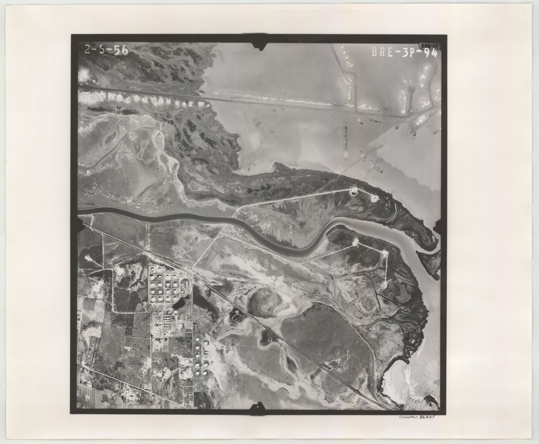
Flight Mission No. BRE-3P, Frame 94, Nueces County
BRE-3P-94
-
Map/Doc
86825
-
Collection
General Map Collection
-
Object Dates
1956/2/6 (Creation Date)
-
People and Organizations
U. S. Department of Agriculture (Publisher)
-
Counties
Nueces
-
Subjects
Aerial Photograph
-
Height x Width
18.5 x 22.4 inches
47.0 x 56.9 cm
-
Comments
Flown by V. L. Beavers and Associates of San Antonio, Texas.
Part of: General Map Collection
Montgomery County Working Sketch 56

Print $20.00
- Digital $50.00
Montgomery County Working Sketch 56
1961
Size 21.2 x 24.0 inches
Map/Doc 71163
Flight Mission No. DJV-3P, Frame 14, Ellis County

Print $20.00
- Digital $50.00
Flight Mission No. DJV-3P, Frame 14, Ellis County
1956
Size 18.8 x 22.4 inches
Map/Doc 84976
Sherman County Sketch File B

Print $6.00
- Digital $50.00
Sherman County Sketch File B
1919
Size 14.4 x 8.8 inches
Map/Doc 36691
Flight Mission No. BRE-1P, Frame 67, Nueces County

Print $20.00
- Digital $50.00
Flight Mission No. BRE-1P, Frame 67, Nueces County
1956
Size 18.7 x 22.4 inches
Map/Doc 86649
Culberson County Working Sketch 37

Print $20.00
- Digital $50.00
Culberson County Working Sketch 37
1966
Size 22.4 x 40.5 inches
Map/Doc 68490
Rockwall County

Print $20.00
- Digital $50.00
Rockwall County
1941
Size 26.0 x 21.3 inches
Map/Doc 77410
San Saba County Sketch File 13

Print $20.00
- Digital $50.00
San Saba County Sketch File 13
1890
Size 20.9 x 19.2 inches
Map/Doc 12291
Stonewall County Working Sketch 9

Print $20.00
- Digital $50.00
Stonewall County Working Sketch 9
1950
Size 27.9 x 34.1 inches
Map/Doc 62316
Trinity County Sketch File 19

Print $20.00
- Digital $50.00
Trinity County Sketch File 19
Size 16.6 x 16.7 inches
Map/Doc 12484
Montgomery County Working Sketch 76

Print $20.00
- Digital $50.00
Montgomery County Working Sketch 76
Size 16.5 x 18.3 inches
Map/Doc 78191
Texas Gulf Coast Map from the Sabine River to the Rio Grande as subdivided for mineral development

Print $20.00
- Digital $50.00
Texas Gulf Coast Map from the Sabine River to the Rio Grande as subdivided for mineral development
1966
Size 29.1 x 41.7 inches
Map/Doc 2496
Bowie County Rolled Sketch 1

Print $20.00
- Digital $50.00
Bowie County Rolled Sketch 1
1965
Size 32.0 x 46.1 inches
Map/Doc 8927
You may also like
San Saba County

Print $20.00
- Digital $50.00
San Saba County
1918
Size 23.6 x 18.4 inches
Map/Doc 78397
Cooke County Sketch File 45

Print $20.00
- Digital $50.00
Cooke County Sketch File 45
1849
Size 22.3 x 15.2 inches
Map/Doc 11179
Burleson County Working Sketch 2

Print $20.00
- Digital $50.00
Burleson County Working Sketch 2
1976
Size 36.4 x 31.2 inches
Map/Doc 67721
Cameron County Rolled Sketch 10A

Print $71.00
- Digital $50.00
Cameron County Rolled Sketch 10A
Size 11.1 x 8.7 inches
Map/Doc 41749
Newton County Working Sketch 16

Print $20.00
- Digital $50.00
Newton County Working Sketch 16
1950
Size 15.8 x 15.5 inches
Map/Doc 71262
Minnesota Route the shortest and best to the Idaho Gold Mines

Print $20.00
- Digital $50.00
Minnesota Route the shortest and best to the Idaho Gold Mines
Size 21.0 x 46.3 inches
Map/Doc 93989
Webb County Sketch File 8a

Print $4.00
- Digital $50.00
Webb County Sketch File 8a
Size 7.9 x 8.7 inches
Map/Doc 39743
Coleman County Sketch File 24a

Print $6.00
- Digital $50.00
Coleman County Sketch File 24a
1872
Size 10.2 x 15.9 inches
Map/Doc 18708
[Leagues 212- 217, 241- 244, and Vicinity]
![91430, [Leagues 212- 217, 241- 244, and Vicinity], Twichell Survey Records](https://historictexasmaps.com/wmedia_w700/maps/91430-1.tif.jpg)
Print $20.00
- Digital $50.00
[Leagues 212- 217, 241- 244, and Vicinity]
1902
Size 20.6 x 6.4 inches
Map/Doc 91430
Brewster County Working Sketch 58

Print $20.00
- Digital $50.00
Brewster County Working Sketch 58
1955
Size 19.8 x 21.7 inches
Map/Doc 67659
Sketch Showing Lands Conveyed to Texas State Park Board by the City of Lubbock, Texas for the Location of MacKenzie State Park

Print $20.00
- Digital $50.00
Sketch Showing Lands Conveyed to Texas State Park Board by the City of Lubbock, Texas for the Location of MacKenzie State Park
1935
Size 26.4 x 33.1 inches
Map/Doc 92724
Freestone County Rolled Sketch 11

Print $20.00
- Digital $50.00
Freestone County Rolled Sketch 11
1934
Size 17.9 x 34.1 inches
Map/Doc 5911