San Saba County Sketch File 13
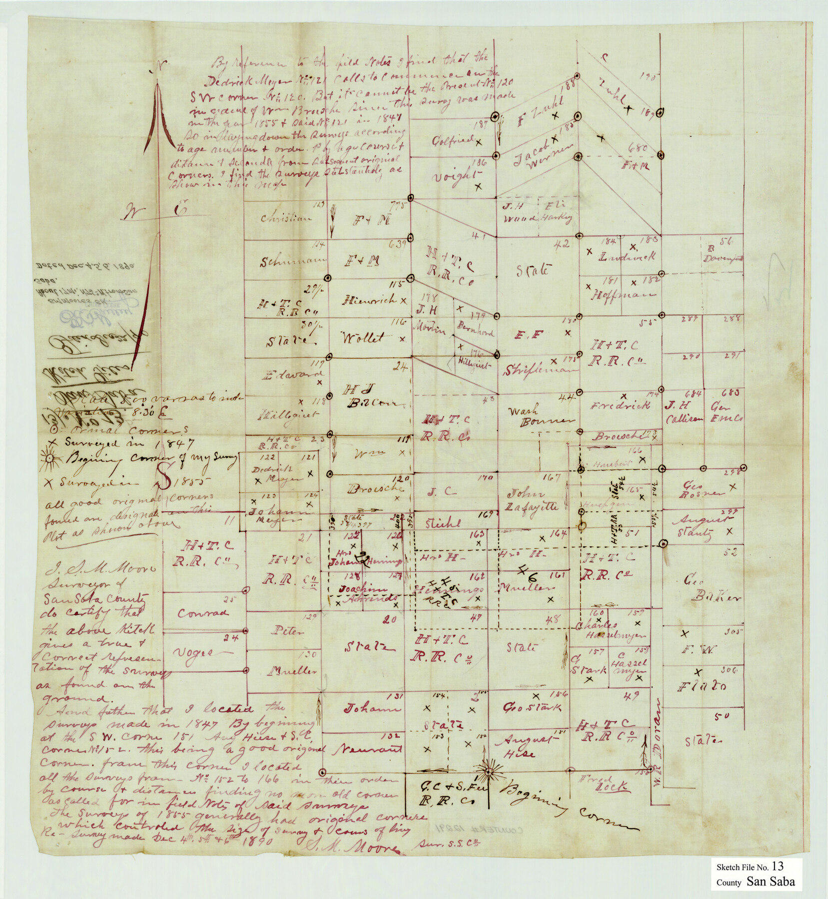
[Sketch of surveys in western San Saba County in area surrounding H. & T. C. survey no. 42]
-
Map/Doc
12291
-
Collection
General Map Collection
-
Object Dates
12/6/1890 (Creation Date)
12/22/1890 (File Date)
-
People and Organizations
S.M. Moore (Surveyor/Engineer)
-
Counties
San Saba
-
Subjects
Surveying Sketch File
-
Height x Width
20.9 x 19.2 inches
53.1 x 48.8 cm
-
Medium
paper, manuscript
Part of: General Map Collection
Brown County Working Sketch 4

Print $20.00
- Digital $50.00
Brown County Working Sketch 4
1926
Size 23.4 x 22.4 inches
Map/Doc 67769
Bailey County Sketch File 2a

Print $6.00
- Digital $50.00
Bailey County Sketch File 2a
1892
Size 13.0 x 8.3 inches
Map/Doc 13935
Grimes County Working Sketch 18

Print $20.00
- Digital $50.00
Grimes County Working Sketch 18
1990
Size 33.1 x 42.5 inches
Map/Doc 63309

Kaufman County Working Sketch 9

Print $20.00
- Digital $50.00
Kaufman County Working Sketch 9
1988
Size 35.9 x 29.8 inches
Map/Doc 66672
Kerr County Working Sketch 15

Print $20.00
- Digital $50.00
Kerr County Working Sketch 15
1953
Size 36.2 x 38.6 inches
Map/Doc 70046
El Paso County Boundary File 7

Print $14.00
- Digital $50.00
El Paso County Boundary File 7
Size 14.0 x 8.8 inches
Map/Doc 53087
Harris County Working Sketch 61

Print $20.00
- Digital $50.00
Harris County Working Sketch 61
1954
Size 22.2 x 24.3 inches
Map/Doc 65953
Montague County Working Sketch 42

Print $20.00
- Digital $50.00
Montague County Working Sketch 42
2009
Size 19.9 x 25.4 inches
Map/Doc 89004
Sherman County Rolled Sketch 9

Print $20.00
- Digital $50.00
Sherman County Rolled Sketch 9
1942
Size 33.5 x 26.7 inches
Map/Doc 7789
McMullen County Working Sketch 14

Print $20.00
- Digital $50.00
McMullen County Working Sketch 14
1938
Size 28.6 x 37.1 inches
Map/Doc 70715
Midland County Sketch File 7

Print $20.00
- Digital $50.00
Midland County Sketch File 7
1930
Size 33.1 x 23.7 inches
Map/Doc 12083
You may also like
Carte Geographique, Statistique et Historique du Mexique

Print $20.00
Carte Geographique, Statistique et Historique du Mexique
1824
Size 22.3 x 28.1 inches
Map/Doc 79315
Red River County

Print $20.00
- Digital $50.00
Red River County
1934
Size 46.0 x 39.2 inches
Map/Doc 73272
Flight Mission No. CGI-3N, Frame 45, Cameron County

Print $20.00
- Digital $50.00
Flight Mission No. CGI-3N, Frame 45, Cameron County
1954
Size 18.5 x 22.2 inches
Map/Doc 84551
Bowie County Rolled Sketch 1

Print $20.00
- Digital $50.00
Bowie County Rolled Sketch 1
1965
Size 32.0 x 46.1 inches
Map/Doc 8927
Upton County Working Sketch 8

Print $20.00
- Digital $50.00
Upton County Working Sketch 8
1916
Size 21.9 x 16.8 inches
Map/Doc 69504
Hays County Working Sketch 10

Print $20.00
- Digital $50.00
Hays County Working Sketch 10
1949
Size 23.4 x 25.8 inches
Map/Doc 66084
Flight Mission No. CRC-2R, Frame 190, Chambers County

Print $20.00
- Digital $50.00
Flight Mission No. CRC-2R, Frame 190, Chambers County
1956
Size 18.8 x 22.4 inches
Map/Doc 84768
Crosby County Working Sketch 15

Print $20.00
- Digital $50.00
Crosby County Working Sketch 15
1977
Size 34.0 x 35.9 inches
Map/Doc 68449
West Part El Paso Co.

Print $20.00
- Digital $50.00
West Part El Paso Co.
1908
Size 46.8 x 42.4 inches
Map/Doc 4713
[Sketch Showing Connections from Jeremiah McDonald resurvey]
![91154, [Sketch Showing Connections from Jeremiah McDonald resurvey], Twichell Survey Records](https://historictexasmaps.com/wmedia_w700/maps/91154-1.tif.jpg)
Print $20.00
- Digital $50.00
[Sketch Showing Connections from Jeremiah McDonald resurvey]
Size 21.6 x 14.5 inches
Map/Doc 91154
Hale County Rolled Sketch 9

Print $20.00
- Digital $50.00
Hale County Rolled Sketch 9
Size 25.1 x 17.6 inches
Map/Doc 6047
Texas City Channel, Texas, Channel and Turning Basin Dredging - Sheet 1

Print $20.00
- Digital $50.00
Texas City Channel, Texas, Channel and Turning Basin Dredging - Sheet 1
1958
Size 29.3 x 40.8 inches
Map/Doc 61831