Cameron County Rolled Sketch 10A
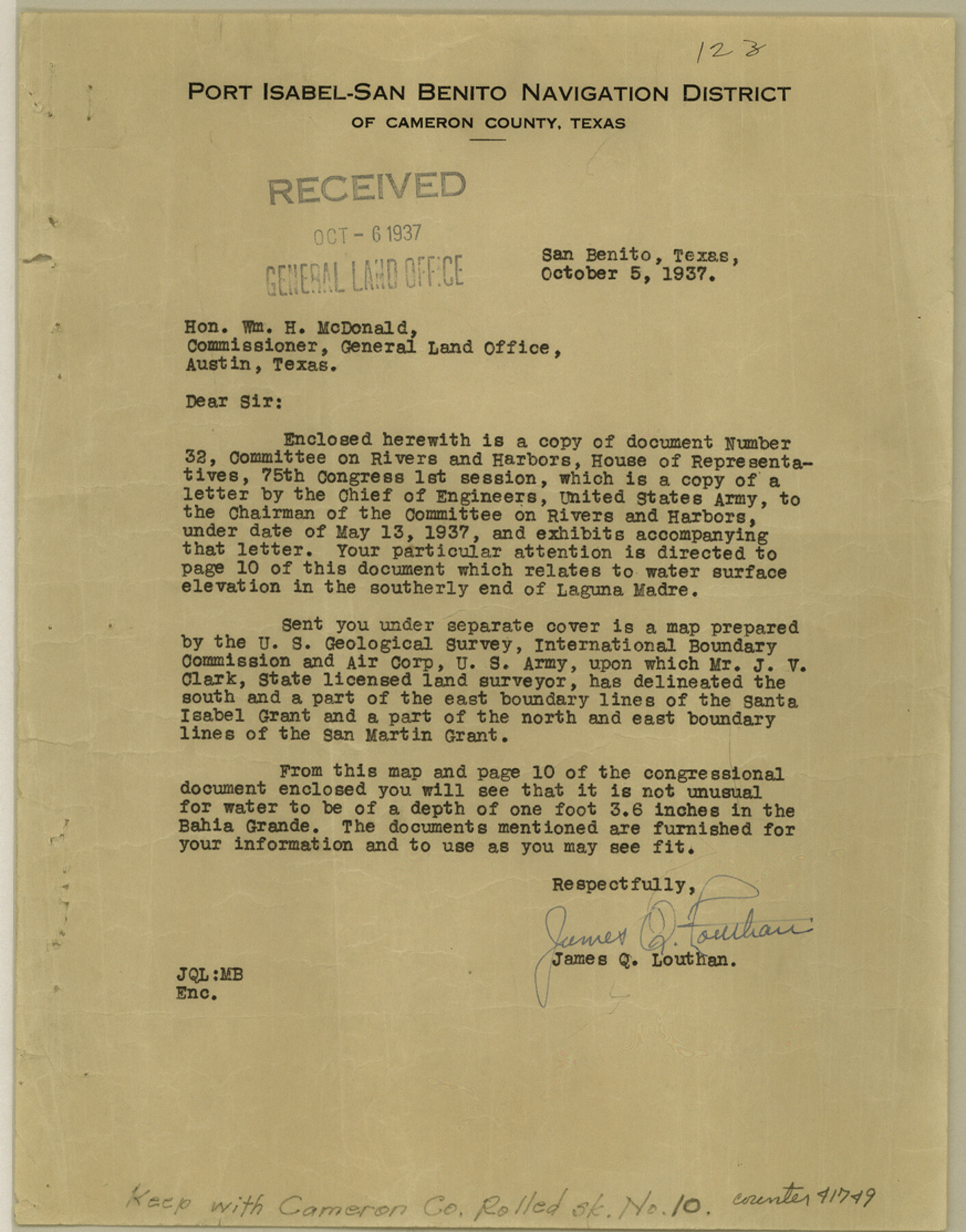
[Letter and copy of document No. 32, Committee on Rivers and Harbors, House of Representatives, 75th Congress, 1st Session relating to water surface elevation in the southerly end of the Laguna Madre]
-
Map/Doc
41749
-
Collection
General Map Collection
-
Object Dates
1937/10/5 (Correspondence Date)
1937/10/6 (File Date)
-
People and Organizations
James Q. Louthan (Surveyor/Engineer)
-
Counties
Cameron
-
Subjects
Surveying Rolled Sketch
-
Height x Width
11.1 x 8.7 inches
28.2 x 22.1 cm
-
Medium
paper, print
-
Comments
See Cameron County Rolled Sketch 10 (8566) for map.
Related maps
Cameron County Rolled Sketch 10

Print $20.00
- Digital $50.00
Cameron County Rolled Sketch 10
Size 38.5 x 44.5 inches
Map/Doc 8566
Part of: General Map Collection
Map of Henderson County

Print $20.00
- Digital $50.00
Map of Henderson County
1877
Size 17.7 x 29.2 inches
Map/Doc 3666
Intracoastal Waterway in Texas - Corpus Christi to Point Isabel including Arroyo Colorado to Mo. Pac. R.R. Bridge Near Harlingen

Print $20.00
- Digital $50.00
Intracoastal Waterway in Texas - Corpus Christi to Point Isabel including Arroyo Colorado to Mo. Pac. R.R. Bridge Near Harlingen
1933
Size 27.9 x 40.8 inches
Map/Doc 61862
Marion County Working Sketch 40

Print $20.00
- Digital $50.00
Marion County Working Sketch 40
1992
Size 42.9 x 30.0 inches
Map/Doc 70816
Hall County Rolled Sketch 3

Print $20.00
- Digital $50.00
Hall County Rolled Sketch 3
1890
Size 12.6 x 22.6 inches
Map/Doc 6048
United States Bathymetric and Fishing Maps including Topographic/Bathymetric Maps

Print $40.00
- Digital $50.00
United States Bathymetric and Fishing Maps including Topographic/Bathymetric Maps
1989
Size 21.8 x 54.8 inches
Map/Doc 73556
University Land Field Notes for Blocks 1, 2, 3, 4, 5, 8, 9, and 10 in Andrews County, Block 6 in Andrews, Dawson, Gaines, and Martin Counties, and Block 7 in Andrews and Martin Counties

University Land Field Notes for Blocks 1, 2, 3, 4, 5, 8, 9, and 10 in Andrews County, Block 6 in Andrews, Dawson, Gaines, and Martin Counties, and Block 7 in Andrews and Martin Counties
Map/Doc 81710
Nacogdoches Co.

Print $40.00
- Digital $50.00
Nacogdoches Co.
1905
Size 50.7 x 42.0 inches
Map/Doc 10787
Flight Mission No. DQO-3K, Frame 14, Galveston County

Print $20.00
- Digital $50.00
Flight Mission No. DQO-3K, Frame 14, Galveston County
1952
Size 18.8 x 22.4 inches
Map/Doc 85055
Cameron County Rolled Sketch 22

Print $63.00
- Digital $50.00
Cameron County Rolled Sketch 22
Size 9.8 x 15.0 inches
Map/Doc 43919
Map of Archer County

Print $20.00
- Digital $50.00
Map of Archer County
1886
Size 24.4 x 20.5 inches
Map/Doc 3240
Surveys in Austin's Colony along the east fork of Mill Creek

Print $20.00
- Digital $50.00
Surveys in Austin's Colony along the east fork of Mill Creek
1830
Size 23.7 x 12.6 inches
Map/Doc 208
Loving County Working Sketch 2

Print $20.00
- Digital $50.00
Loving County Working Sketch 2
1937
Size 33.9 x 42.5 inches
Map/Doc 70634
You may also like
Map of Jones County

Print $20.00
- Digital $50.00
Map of Jones County
1898
Size 41.9 x 39.8 inches
Map/Doc 4996
Flight Mission No. DAG-21K, Frame 36, Matagorda County

Print $20.00
- Digital $50.00
Flight Mission No. DAG-21K, Frame 36, Matagorda County
1952
Size 18.5 x 22.3 inches
Map/Doc 86403
Smith County Rolled Sketch 1

Print $20.00
- Digital $50.00
Smith County Rolled Sketch 1
Size 42.4 x 34.8 inches
Map/Doc 9932
Flight Mission No. CUG-3P, Frame 92, Kleberg County

Print $20.00
- Digital $50.00
Flight Mission No. CUG-3P, Frame 92, Kleberg County
1956
Size 18.4 x 22.2 inches
Map/Doc 86262
Sanderson and Terrell County, Texas

Sanderson and Terrell County, Texas
1920
Size 6.3 x 3.5 inches
Map/Doc 97073
Lee County Working Sketch 3

Print $20.00
- Digital $50.00
Lee County Working Sketch 3
1968
Size 37.9 x 37.3 inches
Map/Doc 70382
[Western part of Crockett County]
![90323, [Western part of Crockett County], Twichell Survey Records](https://historictexasmaps.com/wmedia_w700/maps/90323-1.tif.jpg)
Print $20.00
- Digital $50.00
[Western part of Crockett County]
Size 17.3 x 14.3 inches
Map/Doc 90323
Runnels County Rolled Sketch 44

Print $40.00
- Digital $50.00
Runnels County Rolled Sketch 44
Size 43.0 x 53.9 inches
Map/Doc 9871

Runnels County Rolled Sketch 18

Print $20.00
- Digital $50.00
Runnels County Rolled Sketch 18
Size 23.1 x 25.3 inches
Map/Doc 7513
Refugio County Working Sketch 15

Print $20.00
- Digital $50.00
Refugio County Working Sketch 15
1963
Size 23.9 x 14.3 inches
Map/Doc 63524
Webb County Sketch File 1-1

Print $4.00
- Digital $50.00
Webb County Sketch File 1-1
1857
Size 8.6 x 8.4 inches
Map/Doc 39708