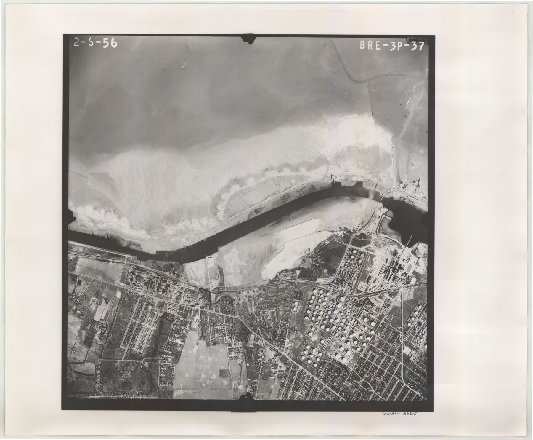
Flight Mission No. BRE-3P, Frame 37, Nueces County
BRE-3P-37
-
Map/Doc
86815
-
Collection
General Map Collection
-
Object Dates
1956/2/6 (Creation Date)
-
People and Organizations
U. S. Department of Agriculture (Publisher)
-
Counties
Nueces
-
Subjects
Aerial Photograph
-
Height x Width
18.4 x 22.4 inches
46.7 x 56.9 cm
-
Comments
Flown by V. L. Beavers and Associates of San Antonio, Texas.
Part of: General Map Collection
Webb County Sketch File Z

Print $20.00
- Digital $50.00
Webb County Sketch File Z
1901
Size 16.8 x 22.2 inches
Map/Doc 12610
Childress County Sketch File 14

Print $12.00
- Digital $50.00
Childress County Sketch File 14
1896
Size 9.8 x 6.3 inches
Map/Doc 18272
Jefferson County Sketch File 25

Print $14.00
- Digital $50.00
Jefferson County Sketch File 25
1896
Size 7.6 x 6.7 inches
Map/Doc 28184
La Salle County Sketch File 27

Print $22.00
- Digital $50.00
La Salle County Sketch File 27
Size 8.8 x 14.1 inches
Map/Doc 29553
Fisher County Rolled Sketch 7

Print $20.00
- Digital $50.00
Fisher County Rolled Sketch 7
2009
Size 28.6 x 24.6 inches
Map/Doc 89988
Padre Island National Seashore

Print $4.00
- Digital $50.00
Padre Island National Seashore
Size 16.0 x 22.3 inches
Map/Doc 60532
Edwards County Working Sketch 5

Print $20.00
- Digital $50.00
Edwards County Working Sketch 5
1907
Size 14.9 x 23.4 inches
Map/Doc 68881
Webb County Working Sketch 35

Print $40.00
- Digital $50.00
Webb County Working Sketch 35
1939
Size 54.5 x 36.2 inches
Map/Doc 72400
Garza County Sketch File 20

Print $20.00
- Digital $50.00
Garza County Sketch File 20
1905
Size 8.7 x 7.8 inches
Map/Doc 24068

Flight Mission No. CGI-3N, Frame 174, Cameron County

Print $20.00
- Digital $50.00
Flight Mission No. CGI-3N, Frame 174, Cameron County
1954
Size 18.5 x 22.1 inches
Map/Doc 84638
Freestone County Sketch File 10

Print $40.00
- Digital $50.00
Freestone County Sketch File 10
Size 13.0 x 13.5 inches
Map/Doc 23058
You may also like
Tyler County Sketch File 23

Print $20.00
- Digital $50.00
Tyler County Sketch File 23
Size 25.3 x 20.9 inches
Map/Doc 12500
Colorado River, Matagorda Sheet

Print $6.00
- Digital $50.00
Colorado River, Matagorda Sheet
1937
Size 30.9 x 35.8 inches
Map/Doc 65303
[I. & G. N. Block 1]
![91588, [I. & G. N. Block 1], Twichell Survey Records](https://historictexasmaps.com/wmedia_w700/maps/91588-1.tif.jpg)
Print $20.00
- Digital $50.00
[I. & G. N. Block 1]
Size 11.8 x 18.6 inches
Map/Doc 91588
Childress Co.

Print $20.00
- Digital $50.00
Childress Co.
1978
Size 44.6 x 33.7 inches
Map/Doc 77237
Lynn County Sketch File A

Print $2.00
- Digital $50.00
Lynn County Sketch File A
1905
Size 8.6 x 6.3 inches
Map/Doc 30477
Van Zandt County Sketch File 19

Print $4.00
- Digital $50.00
Van Zandt County Sketch File 19
1858
Size 9.7 x 7.7 inches
Map/Doc 39422
Crane County Rolled Sketch 23

Print $20.00
- Digital $50.00
Crane County Rolled Sketch 23
2002
Size 23.9 x 34.3 inches
Map/Doc 76426
Ward County Rolled Sketch 12A

Print $20.00
- Digital $50.00
Ward County Rolled Sketch 12A
Size 34.7 x 46.5 inches
Map/Doc 10108
General Highway Map, Colorado County, Texas

Print $20.00
General Highway Map, Colorado County, Texas
1940
Size 25.1 x 18.5 inches
Map/Doc 79054
Map of Jefferson County

Print $20.00
- Digital $50.00
Map of Jefferson County
1862
Size 22.5 x 21.9 inches
Map/Doc 3727
Hopkins County Sketch File 9

Print $6.00
- Digital $50.00
Hopkins County Sketch File 9
1856
Size 12.8 x 8.3 inches
Map/Doc 26697
Edwards County Working Sketch 108

Print $40.00
- Digital $50.00
Edwards County Working Sketch 108
1972
Size 61.2 x 37.1 inches
Map/Doc 68984