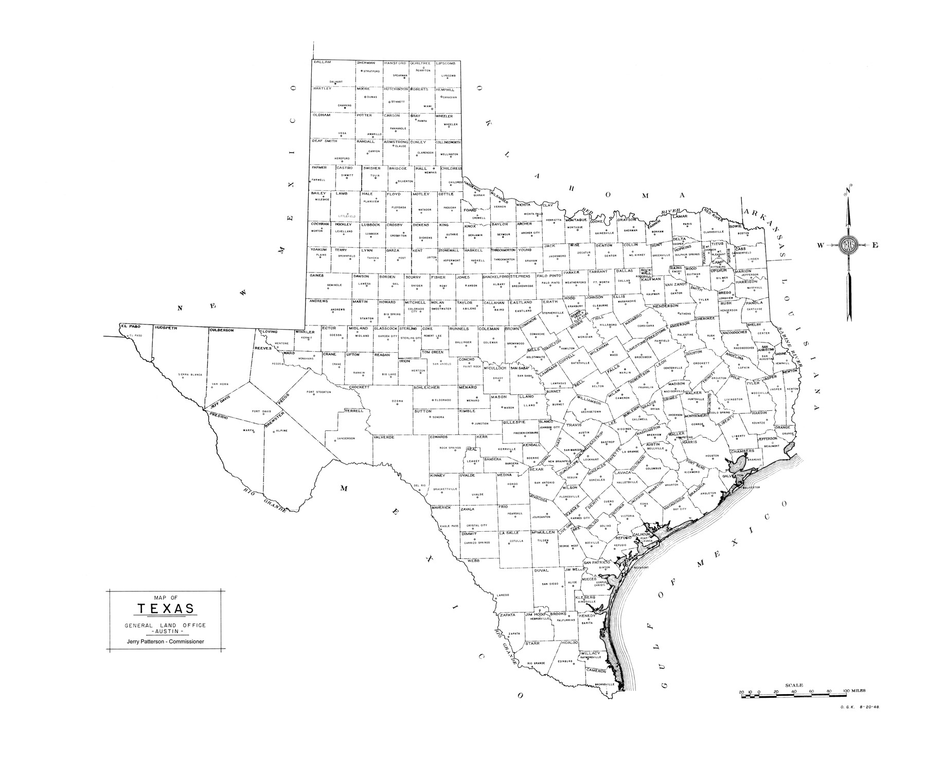
Map of Texas
-
Map/Doc
82034
-
Collection
General Map Collection
-
People and Organizations
General Land Office (Publisher)
Jerry E. Patterson (GLO Commissioner)
-
Subjects
State of Texas
-
Height x Width
34.7 x 42.3 inches
88.1 x 107.4 cm
-
Medium
paper
-
Scale
25 miles
-
Comments
Basic map of Texas showing counties and county seats.
Part of: General Map Collection
Trace of a copy of the map captured at the battle of Resaca de la Palma

Print $20.00
- Digital $50.00
Trace of a copy of the map captured at the battle of Resaca de la Palma
Size 18.4 x 27.4 inches
Map/Doc 73055
Limestone County Sketch File 16

Print $4.00
- Digital $50.00
Limestone County Sketch File 16
Size 12.8 x 8.3 inches
Map/Doc 30185
Map of University Land part of Fifty League Grant Act of 1839

Print $20.00
- Digital $50.00
Map of University Land part of Fifty League Grant Act of 1839
1905
Size 40.7 x 28.7 inches
Map/Doc 2430
Flight Mission No. DQN-5K, Frame 149, Calhoun County

Print $20.00
- Digital $50.00
Flight Mission No. DQN-5K, Frame 149, Calhoun County
1953
Size 18.5 x 22.2 inches
Map/Doc 84424

Map of Madison County

Print $20.00
- Digital $50.00
Map of Madison County
1880
Size 17.0 x 24.9 inches
Map/Doc 3832
Copy of a portion of Arista's map

Print $20.00
- Digital $50.00
Copy of a portion of Arista's map
1847
Size 27.5 x 18.3 inches
Map/Doc 73058
Hale County Sketch File 14

Print $8.00
- Digital $50.00
Hale County Sketch File 14
Size 14.1 x 8.7 inches
Map/Doc 24743
Throckmorton County Sketch File 6

Print $27.00
- Digital $50.00
Throckmorton County Sketch File 6
1888
Size 9.0 x 6.9 inches
Map/Doc 38076
Sterling County Sketch File 17x

Print $4.00
- Digital $50.00
Sterling County Sketch File 17x
Size 9.0 x 13.7 inches
Map/Doc 37165
Harris County Rolled Sketch 80A

Print $40.00
- Digital $50.00
Harris County Rolled Sketch 80A
Size 42.8 x 52.6 inches
Map/Doc 9136
Flight Mission No. DAG-21K, Frame 37, Matagorda County

Print $20.00
- Digital $50.00
Flight Mission No. DAG-21K, Frame 37, Matagorda County
1952
Size 18.5 x 22.4 inches
Map/Doc 86404
You may also like
Mileage Map - Best Roads of Texas showing principal cities, pole markings, road distances

Print $20.00
- Digital $50.00
Mileage Map - Best Roads of Texas showing principal cities, pole markings, road distances
1920
Size 12.8 x 16.2 inches
Map/Doc 95898
Hansford County Working Sketch 2

Print $40.00
- Digital $50.00
Hansford County Working Sketch 2
1934
Size 42.7 x 54.4 inches
Map/Doc 63374
Harris County Historic Topographic 32

Print $20.00
- Digital $50.00
Harris County Historic Topographic 32
1916
Size 29.3 x 21.6 inches
Map/Doc 65843
Hall County Boundary File 1c

Print $40.00
- Digital $50.00
Hall County Boundary File 1c
Size 10.0 x 34.6 inches
Map/Doc 54175
Frio County Rolled Sketch 13

Print $20.00
- Digital $50.00
Frio County Rolled Sketch 13
1949
Size 36.8 x 26.7 inches
Map/Doc 5920
Donley County Boundary File 1

Print $12.00
- Digital $50.00
Donley County Boundary File 1
Size 11.1 x 8.6 inches
Map/Doc 52613
Primera parte del Mapa, que comprende la Frontera, de los Dominios del Rey, en la America Septentrional

Print $40.00
- Digital $50.00
Primera parte del Mapa, que comprende la Frontera, de los Dominios del Rey, en la America Septentrional
1769
Size 25.8 x 63.2 inches
Map/Doc 3062
Leon County Working Sketch 24

Print $20.00
- Digital $50.00
Leon County Working Sketch 24
1967
Size 23.3 x 29.0 inches
Map/Doc 70423
Val Verde County Rolled Sketch 22

Print $40.00
- Digital $50.00
Val Verde County Rolled Sketch 22
1892
Size 51.8 x 38.7 inches
Map/Doc 10071
The Republic County of Liberty. January 20, 1841

Print $20.00
The Republic County of Liberty. January 20, 1841
2020
Size 19.9 x 21.7 inches
Map/Doc 96209
Subdivision of Sutton County School League 175. Bailey County, Texas

Print $2.00
- Digital $50.00
Subdivision of Sutton County School League 175. Bailey County, Texas
1929
Size 9.1 x 11.5 inches
Map/Doc 90278
Outer Continental Shelf Leasing Maps (Louisiana Offshore Operations)

Print $20.00
- Digital $50.00
Outer Continental Shelf Leasing Maps (Louisiana Offshore Operations)
1955
Size 10.3 x 11.6 inches
Map/Doc 76088