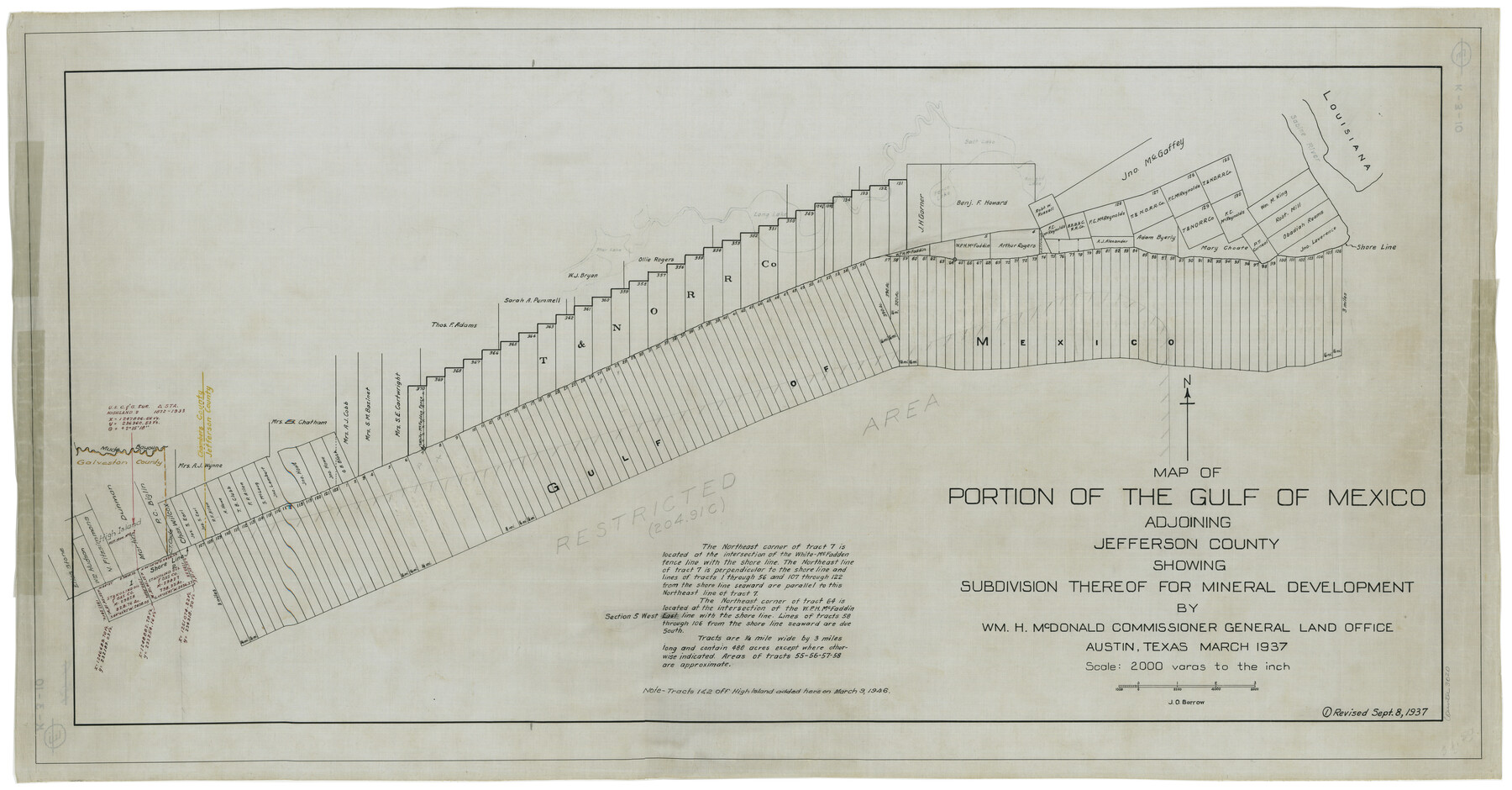
Map of Portion of the Gulf of Mexico Adjoining Jefferson County Showing Subdivision Thereof for Mineral Development
K-3-10
- 
                          Map/Doc
3020
 - 
                            Collection
General Map Collection
 - 
                            Object Dates
1937 (Creation Date)
 - 
                            Subjects
Intracoastal Waterways
 - 
                            Height x Width
20.5 x 39.0 inches
52.1 x 99.1 cm
 
Part of: General Map Collection
            Flight Mission No. CGI-1N, Frame 135, Cameron County


                                            Print $20.00                    
                                             -                         Digital $50.00                                    
                Flight Mission No. CGI-1N, Frame 135, Cameron County
1955
Size 17.2 x 18.7 inches
                                Map/Doc 84491
            
            Harris County Working Sketch 47


                                            Print $40.00                    
                                             -                         Digital $50.00                                    
                Harris County Working Sketch 47
1942
Size 39.5 x 51.9 inches
                                Map/Doc 65939
            
            Maverick County Sketch File 10


                                            Print $22.00                    
                                             -                         Digital $50.00                                    
                Maverick County Sketch File 10
Size 8.6 x 7.0 inches
                                Map/Doc 31072
            
            Burnet County Sketch File 40


                                            Print $4.00                    
                                             -                         Digital $50.00                                    
                Burnet County Sketch File 40
Size 14.2 x 8.6 inches
                                Map/Doc 16755
            
            Flight Mission No. BQR-22K, Frame 41, Brazoria County


                                            Print $20.00                    
                                             -                         Digital $50.00                                    
                Flight Mission No. BQR-22K, Frame 41, Brazoria County
1953
Size 18.8 x 22.5 inches
                                Map/Doc 84125
            
            Hemphill County Working Sketch 8


                                            Print $40.00                    
                                             -                         Digital $50.00                                    
                Hemphill County Working Sketch 8
1965
Size 25.8 x 64.6 inches
                                Map/Doc 66103
            
            Palo Pinto County Sketch File 1


                                            Print $20.00                    
                                             -                         Digital $50.00                                    
                Palo Pinto County Sketch File 1
Size 18.8 x 23.5 inches
                                Map/Doc 12131
            
            Hardin County Working Sketch 44


                                            Print $40.00                    
                                             -                         Digital $50.00                                    
                Hardin County Working Sketch 44
1954
Size 53.1 x 39.5 inches
                                Map/Doc 69764
            
            Guadalupe County Sketch File 20


                                            Print $6.00                    
                                             -                         Digital $50.00                                    
                Guadalupe County Sketch File 20
1912
Size 11.1 x 8.7 inches
                                Map/Doc 24699
            
            Travis County State Real Property Sketch 4


                                            Print $20.00                    
                                             -                         Digital $50.00                                    
                Travis County State Real Property Sketch 4
1987
Size 25.7 x 30.7 inches
                                Map/Doc 61695
            
            Nueces County Rolled Sketch 114


                                            Print $20.00                    
                                             -                         Digital $50.00                                    
                Nueces County Rolled Sketch 114
1992
Size 18.1 x 24.6 inches
                                Map/Doc 7125
            You may also like
            Palo Pinto County Working Sketch 17


                                            Print $40.00                    
                                             -                         Digital $50.00                                    
                Palo Pinto County Working Sketch 17
1974
Size 30.0 x 53.8 inches
                                Map/Doc 71400
            
            Revised Sectional Map No. 3 Showing Land Surveys in Counties of Loving and Reeves and Portions of Winkler, Ward, Pecos, Jeff Davis and El Paso


                                            Print $20.00                    
                                             -                         Digital $50.00                                    
                Revised Sectional Map No. 3 Showing Land Surveys in Counties of Loving and Reeves and Portions of Winkler, Ward, Pecos, Jeff Davis and El Paso
Size 24.7 x 19.4 inches
                                Map/Doc 92902
            
            El Paso County Rolled Sketch 18


                                            Print $20.00                    
                                             -                         Digital $50.00                                    
                El Paso County Rolled Sketch 18
Size 30.0 x 33.4 inches
                                Map/Doc 5822
            
            San Augustine County Sketch File 14


                                            Print $22.00                    
                                    
                San Augustine County Sketch File 14
1888
Size 13.2 x 12.6 inches
                                Map/Doc 35662
            
            Van Zandt County Rolled Sketch 5


                                            Print $20.00                    
                                             -                         Digital $50.00                                    
                Van Zandt County Rolled Sketch 5
1946
Size 27.1 x 28.1 inches
                                Map/Doc 8146
            
            Maps of Gulf Intracoastal Waterway, Texas - Sabine River to the Rio Grande and connecting waterways including ship channels


                                            Print $20.00                    
                                             -                         Digital $50.00                                    
                Maps of Gulf Intracoastal Waterway, Texas - Sabine River to the Rio Grande and connecting waterways including ship channels
1966
Size 14.5 x 22.3 inches
                                Map/Doc 61977
            
            Pecos County Working Sketch 131


                                            Print $5.00                    
                                             -                         Digital $50.00                                    
                Pecos County Working Sketch 131
1977
Size 27.8 x 21.1 inches
                                Map/Doc 71605
            
            Galveston Bay and Approaches


                                            Print $40.00                    
                                             -                         Digital $50.00                                    
                Galveston Bay and Approaches
1982
Size 51.4 x 37.0 inches
                                Map/Doc 69885
            
            Plat Compiled by W. J. Williams, Plainview, Texas, and Sylvan Sanders, Lubbock, Texas Showing Position of Original and Re-Survey Corners in Lynn, Terry, Yoakum, Gaines and Dawson Counties, Texas


                                            Print $40.00                    
                                             -                         Digital $50.00                                    
                Plat Compiled by W. J. Williams, Plainview, Texas, and Sylvan Sanders, Lubbock, Texas Showing Position of Original and Re-Survey Corners in Lynn, Terry, Yoakum, Gaines and Dawson Counties, Texas
1946
Size 57.6 x 22.9 inches
                                Map/Doc 89689
            
            Shackelford County Working Sketch 9


                                            Print $20.00                    
                                             -                         Digital $50.00                                    
                Shackelford County Working Sketch 9
1974
Size 30.1 x 22.2 inches
                                Map/Doc 63849
            
            Goliad County Working Sketch 21


                                            Print $20.00                    
                                             -                         Digital $50.00                                    
                Goliad County Working Sketch 21
1961
Size 42.9 x 39.6 inches
                                Map/Doc 63211