Flight Mission No. BRE-1P, Frame 145, Nueces County
BRE-1P-145
-
Map/Doc
86705
-
Collection
General Map Collection
-
Object Dates
1956/1/13 (Creation Date)
-
People and Organizations
U. S. Department of Agriculture (Publisher)
-
Counties
Nueces
-
Subjects
Aerial Photograph
-
Height x Width
18.4 x 22.1 inches
46.7 x 56.1 cm
-
Comments
Flown by V. L. Beavers and Associates of San Antonio, Texas.
Part of: General Map Collection
Texas, Mexico and part of the United States compiled from the latest and best authorities

Print $20.00
- Digital $50.00
Texas, Mexico and part of the United States compiled from the latest and best authorities
1836
Size 9.1 x 11.0 inches
Map/Doc 95958
Crockett County Sketch File 84

Print $6.00
- Digital $50.00
Crockett County Sketch File 84
1942
Size 11.4 x 8.9 inches
Map/Doc 19905
Aransas County Sketch File 17

Print $40.00
- Digital $50.00
Aransas County Sketch File 17
Size 28.4 x 16.7 inches
Map/Doc 10822
Lampasas County Boundary File Index

Print $2.00
- Digital $50.00
Lampasas County Boundary File Index
Size 9.0 x 9.6 inches
Map/Doc 56092
Wood County Working Sketch 8

Print $20.00
- Digital $50.00
Wood County Working Sketch 8
1943
Size 27.7 x 25.2 inches
Map/Doc 62008
Rusk County Sketch File 9

Print $4.00
Rusk County Sketch File 9
1849
Size 8.4 x 8.2 inches
Map/Doc 35505
Hall County Sketch File 12

Print $20.00
- Digital $50.00
Hall County Sketch File 12
Size 31.9 x 35.5 inches
Map/Doc 10474
Map of Lavaca County

Print $20.00
- Digital $50.00
Map of Lavaca County
1884
Size 21.7 x 22.5 inches
Map/Doc 3804
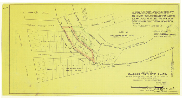
Dallas County Rolled Sketch 4A
Print $20.00
- Digital $50.00
Dallas County Rolled Sketch 4A
1954
Size 12.5 x 23.1 inches
Map/Doc 5688
Travis County Rolled Sketch 35

Print $20.00
- Digital $50.00
Travis County Rolled Sketch 35
1949
Size 22.8 x 24.6 inches
Map/Doc 8036
Travis County Sketch File 27

Print $8.00
- Digital $50.00
Travis County Sketch File 27
1872
Size 12.9 x 8.3 inches
Map/Doc 38338
[Sketch for Mineral Application 26501 - Sabine River, T. A. Oldhausen]
![2838, [Sketch for Mineral Application 26501 - Sabine River, T. A. Oldhausen], General Map Collection](https://historictexasmaps.com/wmedia_w700/maps/2838.tif.jpg)
Print $20.00
- Digital $50.00
[Sketch for Mineral Application 26501 - Sabine River, T. A. Oldhausen]
1931
Size 24.3 x 36.1 inches
Map/Doc 2838
You may also like
Nueces County Sketch File 36

Print $20.00
- Digital $50.00
Nueces County Sketch File 36
1913
Size 17.0 x 18.4 inches
Map/Doc 42189
Trinity River, Porters Bluff Sheet

Print $20.00
- Digital $50.00
Trinity River, Porters Bluff Sheet
1925
Size 27.4 x 23.6 inches
Map/Doc 69689
Wood County Boundary File 3

Print $10.00
- Digital $50.00
Wood County Boundary File 3
Size 12.4 x 8.5 inches
Map/Doc 60162
Chart of the West Indies and Spanish Dominions in North America

Print $20.00
- Digital $50.00
Chart of the West Indies and Spanish Dominions in North America
1803
Size 25.3 x 38.4 inches
Map/Doc 97136
Brewster County Rolled Sketch 100

Print $133.00
- Digital $50.00
Brewster County Rolled Sketch 100
1893
Size 10.1 x 15.4 inches
Map/Doc 43055
Wilbarger County Sketch File 14

Print $4.00
- Digital $50.00
Wilbarger County Sketch File 14
1885
Size 14.2 x 8.7 inches
Map/Doc 40203
Brewster County Working Sketch 90

Print $40.00
- Digital $50.00
Brewster County Working Sketch 90
1975
Size 61.0 x 43.3 inches
Map/Doc 67690
Angelina County Sketch File 22

Print $8.00
- Digital $50.00
Angelina County Sketch File 22
1891
Size 14.0 x 8.7 inches
Map/Doc 13049
Schleicher County Sketch File 27

Print $20.00
- Digital $50.00
Schleicher County Sketch File 27
Size 23.0 x 19.2 inches
Map/Doc 12305
Mississippi River to Galveston

Print $40.00
- Digital $50.00
Mississippi River to Galveston
1973
Size 37.2 x 51.2 inches
Map/Doc 69946
[Surveys in Power and Hewetson's Colony]
![2, [Surveys in Power and Hewetson's Colony], General Map Collection](https://historictexasmaps.com/wmedia_w700/maps/2.tif.jpg)
Print $20.00
- Digital $50.00
[Surveys in Power and Hewetson's Colony]
1830
Size 21.3 x 22.5 inches
Map/Doc 2
Ward County Rolled Sketch 24F

Print $40.00
- Digital $50.00
Ward County Rolled Sketch 24F
Size 30.5 x 65.2 inches
Map/Doc 78232