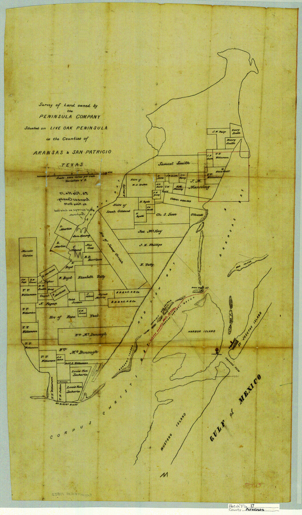
Aransas County Sketch File 17
Survey of land owned by the Peninsula Company situated on Live Oak Peninsula in the counties of Aransas & San Patricio, Texas
- 
                          Map/Doc10822
- 
                            CollectionGeneral Map Collection
- 
                            CountiesAransas San Patricio
- 
                            SubjectsSurveying Sketch File
- 
                            Height x Width28.4 x 16.7 inches72.1 x 42.4 cm
- 
                            Mediumlinen, manuscript
- 
                            Scale1" = 2000 varas
- 
                            FeaturesMustang IslandGulf of MexicoSt. Joseph's IslandCorpus Christi Ship ChannelLight HouseMcGloin's BluffAransas PassCorpus Christ BayRansom IslandLive Oak PeninsulaHog IslandHarbor IslandCorpus Christi BayouRed Fish BayMud IslandAransas BayPuerto Bay
Part of: General Map Collection
            Briscoe County


                                            Print $20.00                    
                                             -                         Digital $50.00                                    
                Briscoe County
1930
Size 46.2 x 39.2 inches
                                Map/Doc 1787
            
            Harris County Historic Topographic 13


                                            Print $20.00                    
                                             -                         Digital $50.00                                    
                Harris County Historic Topographic 13
1915
Size 29.1 x 22.6 inches
                                Map/Doc 65823
            
            McMullen County Working Sketch 42


                                            Print $20.00                    
                                             -                         Digital $50.00                                    
                McMullen County Working Sketch 42
1980
Size 35.6 x 32.6 inches
                                Map/Doc 70743
            
            Plat of All Surveys on the Lavaca Not Heretofor Returned


                                            Print $2.00                    
                                             -                         Digital $50.00                                    
                Plat of All Surveys on the Lavaca Not Heretofor Returned
1841
Size 12.5 x 7.8 inches
                                Map/Doc 78361
            
            Mills County Working Sketch 19


                                            Print $20.00                    
                                             -                         Digital $50.00                                    
                Mills County Working Sketch 19
1963
Size 18.6 x 31.2 inches
                                Map/Doc 71049
            
            Maps of Gulf Intracoastal Waterway, Texas - Sabine River to the Rio Grande and connecting waterways including ship channels


                                            Print $20.00                    
                                             -                         Digital $50.00                                    
                Maps of Gulf Intracoastal Waterway, Texas - Sabine River to the Rio Grande and connecting waterways including ship channels
1966
Size 14.5 x 22.3 inches
                                Map/Doc 61944
            
            Hudspeth County Working Sketch 46


                                            Print $20.00                    
                                             -                         Digital $50.00                                    
                Hudspeth County Working Sketch 46
1983
Size 47.0 x 43.0 inches
                                Map/Doc 66331
            
            Flight Mission No. DIX-8P, Frame 96, Aransas County


                                            Print $20.00                    
                                             -                         Digital $50.00                                    
                Flight Mission No. DIX-8P, Frame 96, Aransas County
1956
Size 18.4 x 22.2 inches
                                Map/Doc 83921
            
            Sterling County Sketch File 23


                                            Print $10.00                    
                                             -                         Digital $50.00                                    
                Sterling County Sketch File 23
1955
Size 11.2 x 8.8 inches
                                Map/Doc 37184
            
            [T. & G. Ry. Main Line, Texas, Right of Way Map, Center to Gary]
            
                                    ![64572, [T. & G. Ry. Main Line, Texas, Right of Way Map, Center to Gary], General Map Collection](https://historictexasmaps.com/wmedia_w700/maps/64572-1.tif.jpg) 


    ![64572, [T. & G. Ry. Main Line, Texas, Right of Way Map, Center to Gary], General Map Collection](https://historictexasmaps.com/wmedia_w700/maps/64572-1.tif.jpg) 
                                
            
                                            Print $40.00                    
                                             -                         Digital $50.00                                    
                [T. & G. Ry. Main Line, Texas, Right of Way Map, Center to Gary]
1917
Size 31.9 x 104.6 inches
                                Map/Doc 64572
            
            Val Verde County Working Sketch 30


                                            Print $20.00                    
                                             -                         Digital $50.00                                    
                Val Verde County Working Sketch 30
1938
Size 37.9 x 28.5 inches
                                Map/Doc 72165
            You may also like
            Lampasas County Boundary File 7


                                            Print $24.00                    
                                             -                         Digital $50.00                                    
                Lampasas County Boundary File 7
Size 12.7 x 8.3 inches
                                Map/Doc 56146
            
            Hamilton County Sketch File C


                                            Print $6.00                    
                                             -                         Digital $50.00                                    
                Hamilton County Sketch File C
Size 12.4 x 11.0 inches
                                Map/Doc 24950
            
            Galveston County Working Sketch 13


                                            Print $20.00                    
                                             -                         Digital $50.00                                    
                Galveston County Working Sketch 13
1975
Size 23.1 x 16.7 inches
                                Map/Doc 69350
            
            Panola County Working Sketch 17


                                            Print $40.00                    
                                             -                         Digital $50.00                                    
                Panola County Working Sketch 17
1945
Map/Doc 71426
            
            Waller County


                                            Print $40.00                    
                                             -                         Digital $50.00                                    
                Waller County
1945
Size 48.9 x 28.4 inches
                                Map/Doc 95665
            
            La Salle County Sketch File 24


                                            Print $4.00                    
                                             -                         Digital $50.00                                    
                La Salle County Sketch File 24
1877
Size 9.2 x 6.1 inches
                                Map/Doc 29547
            
            Johnson County Working Sketch 3


                                            Print $20.00                    
                                             -                         Digital $50.00                                    
                Johnson County Working Sketch 3
1948
Size 29.1 x 24.2 inches
                                Map/Doc 66616
            
            Trinity County Working Sketch 9


                                            Print $20.00                    
                                             -                         Digital $50.00                                    
                Trinity County Working Sketch 9
1947
Size 23.5 x 28.1 inches
                                Map/Doc 69458
            
            University of Texas System University Lands


                                            Print $20.00                    
                                             -                         Digital $50.00                                    
                University of Texas System University Lands
1972
Size 23.2 x 17.9 inches
                                Map/Doc 93250
            
            Ownership Map NE 1/4 Lubbock County


                                            Print $20.00                    
                                             -                         Digital $50.00                                    
                Ownership Map NE 1/4 Lubbock County
Size 37.5 x 39.8 inches
                                Map/Doc 89896
            
            Uvalde County Sketch File 12


                                            Print $18.00                    
                                             -                         Digital $50.00                                    
                Uvalde County Sketch File 12
1887
Size 9.3 x 17.0 inches
                                Map/Doc 38977
             
                             
                                ![91820, [Block M-19], Twichell Survey Records](https://historictexasmaps.com/wmedia_w700/maps/91820-1.tif.jpg)