Travis County Rolled Sketch 35
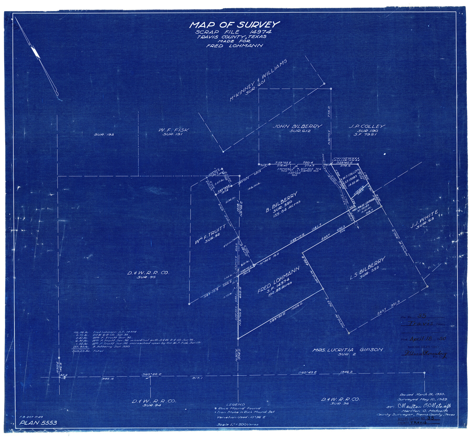
Map of survey, Scrap File 14974, Travis County, Texas made for Fred Lohmann
-
Map/Doc
8036
-
Collection
General Map Collection
-
Object Dates
5/10/1949 (Creation Date)
4/18/1950 (File Date)
3/28/1950 (Revision Date)
-
People and Organizations
Marlton O. Metcalfe (Surveyor/Engineer)
-
Counties
Travis
-
Subjects
Surveying Rolled Sketch
-
Height x Width
22.8 x 24.6 inches
57.9 x 62.5 cm
-
Medium
blueprint/diazo
-
Scale
1" = 200 varas
Part of: General Map Collection
Irion County Rolled Sketch 3

Print $20.00
- Digital $50.00
Irion County Rolled Sketch 3
Size 26.2 x 27.5 inches
Map/Doc 6318
Lavaca County Working Sketch 2

Print $20.00
- Digital $50.00
Lavaca County Working Sketch 2
1904
Size 19.2 x 31.2 inches
Map/Doc 70355

Kaufman County Sketch File 17 1/2

Print $6.00
- Digital $50.00
Kaufman County Sketch File 17 1/2
1888
Size 17.0 x 11.1 inches
Map/Doc 28659
Limestone County Sketch File 27

Print $20.00
- Digital $50.00
Limestone County Sketch File 27
Size 23.2 x 18.8 inches
Map/Doc 12004
Denton County Working Sketch 19

Print $20.00
- Digital $50.00
Denton County Working Sketch 19
1976
Size 24.3 x 27.3 inches
Map/Doc 68624
Map of Johnson County & Hood County

Print $20.00
- Digital $50.00
Map of Johnson County & Hood County
1863
Size 19.3 x 28.3 inches
Map/Doc 3735
Harris County Rolled Sketch 98

Print $20.00
- Digital $50.00
Harris County Rolled Sketch 98
1992
Size 27.1 x 39.5 inches
Map/Doc 6136
Smith County Sketch File 1

Print $4.00
- Digital $50.00
Smith County Sketch File 1
Size 9.0 x 10.5 inches
Map/Doc 36746
Kimble County Sketch File 38

Print $10.00
- Digital $50.00
Kimble County Sketch File 38
1989
Size 3.6 x 4.0 inches
Map/Doc 28992
Aransas County Sketch File 9

Print $40.00
- Digital $50.00
Aransas County Sketch File 9
Size 17.5 x 19.8 inches
Map/Doc 10819
The American Military Pocket Atlas; being an approved Collection of Correct Maps, both general and particular, of the British Colonies; Especially those which now are, or probably may be the Theatre of War

The American Military Pocket Atlas; being an approved Collection of Correct Maps, both general and particular, of the British Colonies; Especially those which now are, or probably may be the Theatre of War
1776
Map/Doc 97398
You may also like
Angelina County Working Sketch Graphic Index

Print $40.00
- Digital $50.00
Angelina County Working Sketch Graphic Index
1945
Size 37.4 x 48.3 inches
Map/Doc 76454
Flight Mission No. DAG-23K, Frame 143, Matagorda County

Print $20.00
- Digital $50.00
Flight Mission No. DAG-23K, Frame 143, Matagorda County
1953
Size 15.8 x 15.7 inches
Map/Doc 86491
Coast Chart No. 211 - Padre I. and Laguna Madre Lat. 27° 12' to Lat. 26° 33' Texas

Print $20.00
- Digital $50.00
Coast Chart No. 211 - Padre I. and Laguna Madre Lat. 27° 12' to Lat. 26° 33' Texas
1890
Size 27.5 x 18.2 inches
Map/Doc 72824
Throckmorton County Sketch File 5

Print $58.00
- Digital $50.00
Throckmorton County Sketch File 5
Size 14.4 x 8.7 inches
Map/Doc 38056
Controlled Mosaic by Jack Amman Photogrammetric Engineers, Inc - Sheet 4

Print $20.00
- Digital $50.00
Controlled Mosaic by Jack Amman Photogrammetric Engineers, Inc - Sheet 4
1954
Size 20.0 x 24.0 inches
Map/Doc 83448
Lavaca County Boundary File 58

Print $20.00
- Digital $50.00
Lavaca County Boundary File 58
Size 8.5 x 7.1 inches
Map/Doc 56259
Irion County Boundary File 3a

Print $2.00
- Digital $50.00
Irion County Boundary File 3a
Size 12.9 x 8.3 inches
Map/Doc 55349

Kaufman County Sketch File 16

Print $4.00
- Digital $50.00
Kaufman County Sketch File 16
Size 10.1 x 8.1 inches
Map/Doc 28655
Outlots Lying Adjacent to Smyer Hockley County, Texas Located on Parts of Labors 7, 8, 13, and 14, League 1. Jones County School Land

Print $20.00
- Digital $50.00
Outlots Lying Adjacent to Smyer Hockley County, Texas Located on Parts of Labors 7, 8, 13, and 14, League 1. Jones County School Land
Size 32.6 x 20.4 inches
Map/Doc 92224
[Sketch of sections 33 and 34]
![91574, [Sketch of sections 33 and 34], Twichell Survey Records](https://historictexasmaps.com/wmedia_w700/maps/91574-1.tif.jpg)
Print $2.00
- Digital $50.00
[Sketch of sections 33 and 34]
Size 5.1 x 8.8 inches
Map/Doc 91574
King County Working Sketch 5

Print $20.00
- Digital $50.00
King County Working Sketch 5
1943
Size 19.2 x 22.0 inches
Map/Doc 70169