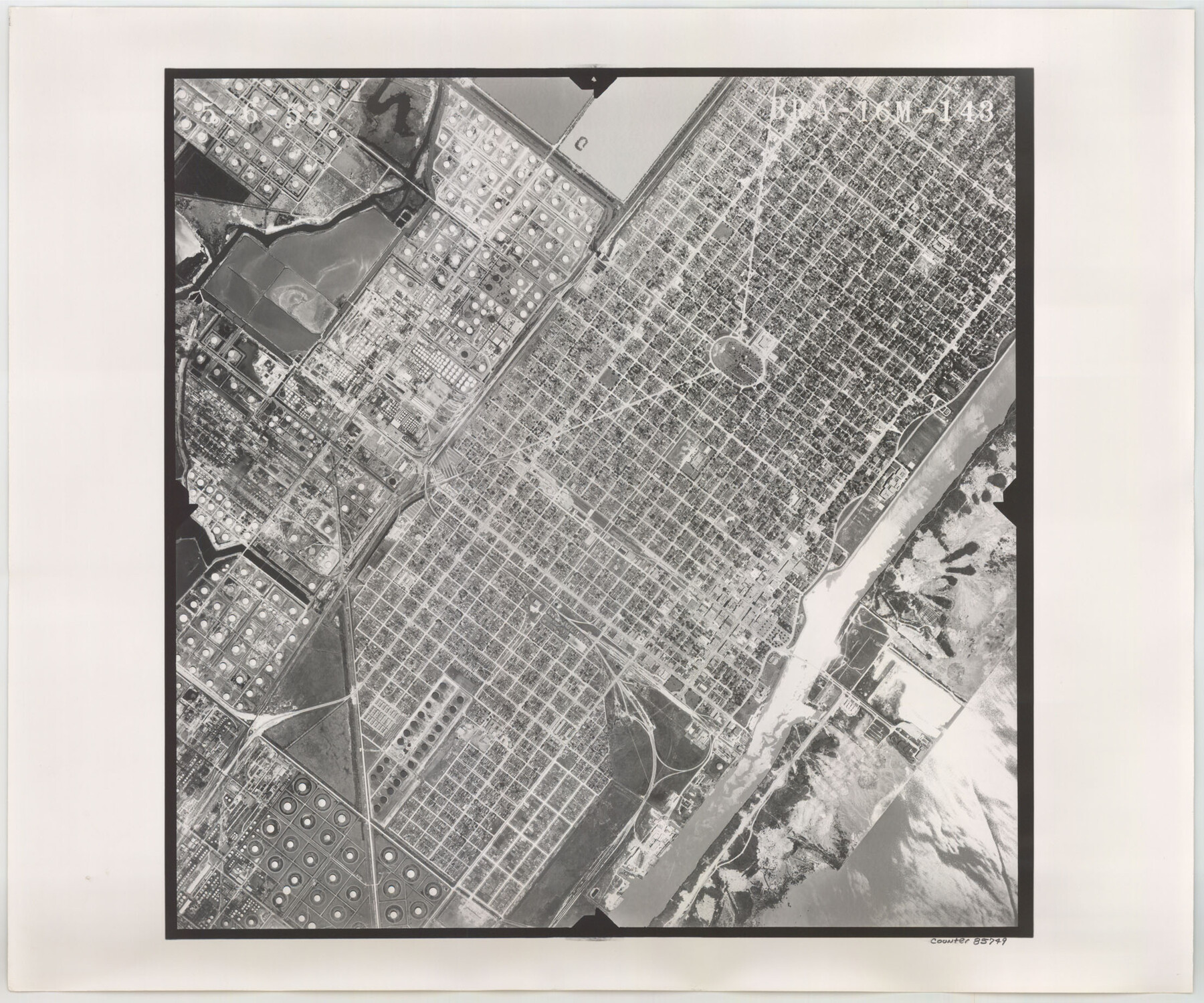
Flight Mission No. BRA-16M, Frame 143, Jefferson County
BRA-16M-143
- 
                          Map/Doc
85749
 - 
                            Collection
General Map Collection
 - 
                            Object Dates
1953/5/6 (Creation Date)
 - 
                            People and Organizations
U. S. Department of Agriculture (Publisher)
 - 
                            Counties
Jefferson
 - 
                            Subjects
Aerial Photograph
 - 
                            Height x Width
18.5 x 22.2 inches
47.0 x 56.4 cm
 - 
                            Comments
Flown by Jack Ammann Photogrammetric Engineers of San Antonio, Texas.
 
Part of: General Map Collection
            Flight Mission No. BRA-3M, Frame 199, Jefferson County


                                            Print $20.00                    
                                             -                         Digital $50.00                                    
                Flight Mission No. BRA-3M, Frame 199, Jefferson County
1953
Size 18.6 x 22.3 inches
                                Map/Doc 85414
            
            Bee County Rolled Sketch 1


                                            Print $20.00                    
                                             -                         Digital $50.00                                    
                Bee County Rolled Sketch 1
2022
Size 24.4 x 36.0 inches
                                Map/Doc 97029
            
            Van Zandt County Rolled Sketch 10


                                            Print $20.00                    
                                             -                         Digital $50.00                                    
                Van Zandt County Rolled Sketch 10
1989
Size 33.7 x 40.6 inches
                                Map/Doc 10092
            
            Map of Texas and Pacific Ry. Company's Surveys in the 80 Mile Reserve


                                            Print $40.00                    
                                             -                         Digital $50.00                                    
                Map of Texas and Pacific Ry. Company's Surveys in the 80 Mile Reserve
1885
Map/Doc 2241
            
            Calhoun County Rolled Sketch 15


                                            Print $20.00                    
                                             -                         Digital $50.00                                    
                Calhoun County Rolled Sketch 15
Size 34.4 x 42.6 inches
                                Map/Doc 8548
            
            Zavala County Boundary File 3


                                            Print $44.00                    
                                             -                         Digital $50.00                                    
                Zavala County Boundary File 3
Size 9.4 x 7.3 inches
                                Map/Doc 60258
            
            Map of the Houston Ship Channel showing all industries, railways, public and private docks, and approximate all original surveys in the vicinity of the channel


                                            Print $20.00                    
                                             -                         Digital $50.00                                    
                Map of the Houston Ship Channel showing all industries, railways, public and private docks, and approximate all original surveys in the vicinity of the channel
1925
Size 14.5 x 30.2 inches
                                Map/Doc 4666
            
            Motley County Sketch File 6B (S)


                                            Print $20.00                    
                                             -                         Digital $50.00                                    
                Motley County Sketch File 6B (S)
Size 24.5 x 20.7 inches
                                Map/Doc 42139
            
            Irion County Rolled Sketch 4


                                            Print $20.00                    
                                             -                         Digital $50.00                                    
                Irion County Rolled Sketch 4
Size 25.6 x 36.4 inches
                                Map/Doc 6319
            
            Hemphill County Rolled Sketch 11


                                            Print $20.00                    
                                             -                         Digital $50.00                                    
                Hemphill County Rolled Sketch 11
1941
Size 45.1 x 21.8 inches
                                Map/Doc 9153
            You may also like
            Flight Mission No. BRA-7M, Frame 129, Jefferson County


                                            Print $20.00                    
                                             -                         Digital $50.00                                    
                Flight Mission No. BRA-7M, Frame 129, Jefferson County
1953
Size 16.3 x 16.0 inches
                                Map/Doc 85523
            
            Wilbarger County Working Sketch 11


                                            Print $40.00                    
                                             -                         Digital $50.00                                    
                Wilbarger County Working Sketch 11
1952
Size 27.7 x 51.7 inches
                                Map/Doc 72549
            
            Flight Mission No. CUG-1P, Frame 113, Kleberg County


                                            Print $20.00                    
                                             -                         Digital $50.00                                    
                Flight Mission No. CUG-1P, Frame 113, Kleberg County
1956
Size 18.8 x 22.2 inches
                                Map/Doc 86163
            
            Flight Mission No. CUG-2P, Frame 8, Kleberg County


                                            Print $20.00                    
                                             -                         Digital $50.00                                    
                Flight Mission No. CUG-2P, Frame 8, Kleberg County
1956
Size 18.5 x 22.2 inches
                                Map/Doc 86180
            
            Smith County Rolled Sketch 3


                                            Print $40.00                    
                                             -                         Digital $50.00                                    
                Smith County Rolled Sketch 3
Size 55.2 x 42.8 inches
                                Map/Doc 9934
            
            Real County Working Sketch 26


                                            Print $20.00                    
                                             -                         Digital $50.00                                    
                Real County Working Sketch 26
1947
Size 28.7 x 28.1 inches
                                Map/Doc 71918
            
            Wilbarger County Sketch File 15


                                            Print $4.00                    
                                             -                         Digital $50.00                                    
                Wilbarger County Sketch File 15
1886
Size 14.4 x 8.8 inches
                                Map/Doc 40205
            
            Pecos County Rolled Sketch DK4


                                            Print $20.00                    
                                             -                         Digital $50.00                                    
                Pecos County Rolled Sketch DK4
Size 41.2 x 30.2 inches
                                Map/Doc 7309
            
            Guadalupe County Sketch File 3a


                                            Print $4.00                    
                                             -                         Digital $50.00                                    
                Guadalupe County Sketch File 3a
1849
Size 10.7 x 8.2 inches
                                Map/Doc 24652
            
            Flight Mission No. DCL-6C, Frame 67, Kenedy County


                                            Print $20.00                    
                                             -                         Digital $50.00                                    
                Flight Mission No. DCL-6C, Frame 67, Kenedy County
1943
Size 18.6 x 22.2 inches
                                Map/Doc 85909
            
            Red River, Bois D'Arc Creek Floodway Sheet No. 2


                                            Print $20.00                    
                                             -                         Digital $50.00                                    
                Red River, Bois D'Arc Creek Floodway Sheet No. 2
1917
Size 20.4 x 29.9 inches
                                Map/Doc 69657
            
            Webb County Rolled Sketch 54


                                            Print $20.00                    
                                             -                         Digital $50.00                                    
                Webb County Rolled Sketch 54
1935
Size 24.7 x 18.8 inches
                                Map/Doc 8206