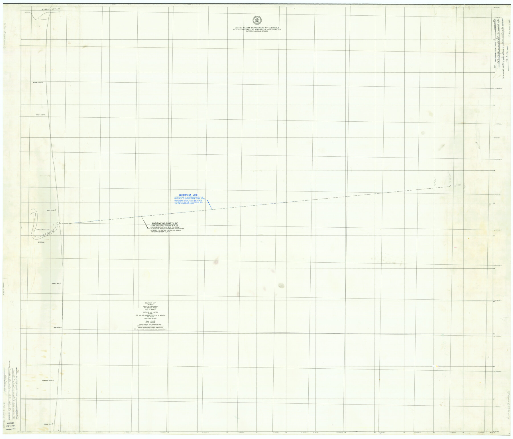
Cameron County Rolled Sketch 18
[Boundary between United States and Mexico in the Gulf of Mexico]
-
Map/Doc
8571
-
Collection
General Map Collection
-
Object Dates
1970 (Creation Date)
1974/10/7 (File Date)
-
People and Organizations
International Boundary and Water Commission (Publisher)
-
Counties
Cameron
-
Subjects
Surveying Rolled Sketch
-
Height x Width
48.9 x 57.1 inches
124.2 x 145.0 cm
-
Medium
multi-page, multi-format
-
Comments
See Cameron County Sketch File 6 (17032) for copy of report.
Related maps
Cameron County Sketch File 6

Print $20.00
- Digital $50.00
Cameron County Sketch File 6
1970
Size 11.0 x 8.5 inches
Map/Doc 17032
Part of: General Map Collection
Foard County Sketch File 1

Print $6.00
- Digital $50.00
Foard County Sketch File 1
Size 10.0 x 9.5 inches
Map/Doc 22804
Archer County Sketch File 26

Print $4.00
- Digital $50.00
Archer County Sketch File 26
1934
Size 9.7 x 4.4 inches
Map/Doc 13663
Cherokee County Sketch File 29

Print $2.00
- Digital $50.00
Cherokee County Sketch File 29
Size 12.9 x 8.2 inches
Map/Doc 18175
Map of Granbury

Print $20.00
- Digital $50.00
Map of Granbury
1960
Size 23.5 x 26.7 inches
Map/Doc 3041
Pecos County Rolled Sketch 138

Print $20.00
- Digital $50.00
Pecos County Rolled Sketch 138
Size 27.9 x 21.7 inches
Map/Doc 7274
Burnet County Sketch File 24

Print $8.00
- Digital $50.00
Burnet County Sketch File 24
1872
Size 7.9 x 10.2 inches
Map/Doc 16721
Dallas County Working Sketch 12

Print $20.00
- Digital $50.00
Dallas County Working Sketch 12
1983
Size 30.5 x 44.1 inches
Map/Doc 68578
Flight Mission No. CRE-2R, Frame 157, Jackson County

Print $20.00
- Digital $50.00
Flight Mission No. CRE-2R, Frame 157, Jackson County
1956
Size 18.4 x 22.3 inches
Map/Doc 85368
Medina County Sketch File 10

Print $20.00
- Digital $50.00
Medina County Sketch File 10
Size 18.0 x 22.6 inches
Map/Doc 12068
Culberson County Sketch File 4

Print $56.00
- Digital $50.00
Culberson County Sketch File 4
1881
Size 14.3 x 8.8 inches
Map/Doc 20123
Milam County Rolled Sketch 3C

Print $20.00
- Digital $50.00
Milam County Rolled Sketch 3C
1959
Size 21.8 x 18.4 inches
Map/Doc 6776
Crockett County Working Sketch 9

Print $20.00
- Digital $50.00
Crockett County Working Sketch 9
1912
Size 24.2 x 32.1 inches
Map/Doc 68342
You may also like
General Highway Map, Crosby County, Texas

Print $20.00
- Digital $50.00
General Highway Map, Crosby County, Texas
1950
Size 25.5 x 18.8 inches
Map/Doc 92597
Upshur County Working Sketch 15b

Print $20.00
- Digital $50.00
Upshur County Working Sketch 15b
1996
Size 36.7 x 29.4 inches
Map/Doc 69572
Brewster County Rolled Sketch 114

Print $20.00
- Digital $50.00
Brewster County Rolled Sketch 114
1964
Size 11.6 x 18.3 inches
Map/Doc 5272
Mills County Boundary File 2

Print $6.00
- Digital $50.00
Mills County Boundary File 2
Size 14.1 x 8.7 inches
Map/Doc 57278
General Highway Map, Knox County, Texas

Print $20.00
General Highway Map, Knox County, Texas
1940
Size 18.3 x 24.8 inches
Map/Doc 79166
Uvalde County Sketch File 19

Print $4.00
- Digital $50.00
Uvalde County Sketch File 19
1882
Size 10.6 x 8.6 inches
Map/Doc 39000
Missouri, Kansas, & Texas Ry.

Print $20.00
- Digital $50.00
Missouri, Kansas, & Texas Ry.
Size 6.7 x 5.4 inches
Map/Doc 96598
Polk County Sketch File 36

Print $46.00
- Digital $50.00
Polk County Sketch File 36
1908
Size 13.8 x 8.6 inches
Map/Doc 34236
Lee County Working Sketch 1

Print $20.00
- Digital $50.00
Lee County Working Sketch 1
1940
Size 26.7 x 26.8 inches
Map/Doc 70380
Liberty County Rolled Sketch OB-1

Print $40.00
- Digital $50.00
Liberty County Rolled Sketch OB-1
1934
Size 70.7 x 25.1 inches
Map/Doc 9564
Medina County Working Sketch 33

Print $20.00
- Digital $50.00
Medina County Working Sketch 33
2006
Size 34.5 x 40.0 inches
Map/Doc 83607
Jasper County Rolled Sketch 8

Print $20.00
- Digital $50.00
Jasper County Rolled Sketch 8
Size 17.8 x 12.0 inches
Map/Doc 6358