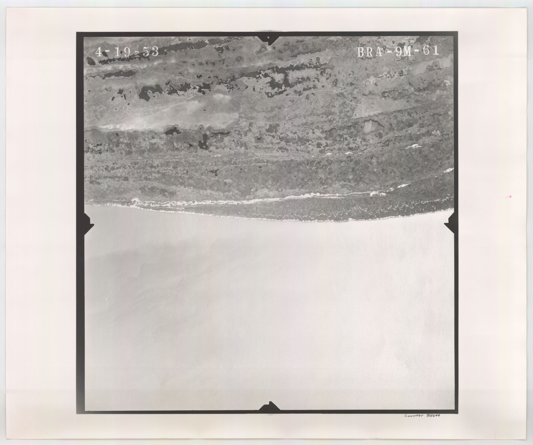
Flight Mission No. BRA-9M, Frame 61, Jefferson County
BRA-9M-61
-
Map/Doc
85644
-
Collection
General Map Collection
-
Object Dates
1953/4/19 (Creation Date)
-
People and Organizations
U. S. Department of Agriculture (Publisher)
-
Counties
Jefferson
-
Subjects
Aerial Photograph
-
Height x Width
18.7 x 22.4 inches
47.5 x 56.9 cm
-
Comments
Flown by Jack Ammann Photogrammetric Engineers of San Antonio, Texas.
Part of: General Map Collection
Presidio County Working Sketch 109

Print $20.00
- Digital $50.00
Presidio County Working Sketch 109
1980
Size 23.3 x 21.4 inches
Map/Doc 71786
Reeves County

Print $20.00
- Digital $50.00
Reeves County
1903
Size 47.3 x 35.6 inches
Map/Doc 66997
Robertson Co.

Print $20.00
- Digital $50.00
Robertson Co.
1889
Size 43.7 x 39.9 inches
Map/Doc 63003
Wharton County Working Sketch 9

Print $3.00
- Digital $50.00
Wharton County Working Sketch 9
1982
Size 12.4 x 10.4 inches
Map/Doc 72473
[Cotton Belt, St. Louis Southwestern Railway of Texas, Alignment through Smith County]
![64385, [Cotton Belt, St. Louis Southwestern Railway of Texas, Alignment through Smith County], General Map Collection](https://historictexasmaps.com/wmedia_w700/maps/64385.tif.jpg)
Print $20.00
- Digital $50.00
[Cotton Belt, St. Louis Southwestern Railway of Texas, Alignment through Smith County]
1903
Size 21.6 x 29.8 inches
Map/Doc 64385
Hydrographic Survey H-1288B Corpus Christi Pass
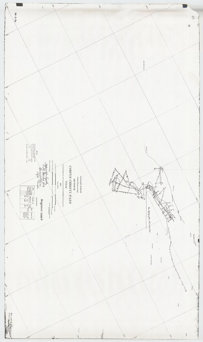
Print $40.00
- Digital $50.00
Hydrographic Survey H-1288B Corpus Christi Pass
1875
Size 52.9 x 31.4 inches
Map/Doc 2691
Childress County Sketch File 15

Print $8.00
- Digital $50.00
Childress County Sketch File 15
Size 14.3 x 8.3 inches
Map/Doc 18278

Sutton County Working Sketch 3

Print $20.00
- Digital $50.00
Sutton County Working Sketch 3
1968
Size 23.6 x 34.5 inches
Map/Doc 62346
Flight Mission No. CUG-1P, Frame 169, Kleberg County

Print $20.00
- Digital $50.00
Flight Mission No. CUG-1P, Frame 169, Kleberg County
1956
Size 18.6 x 22.4 inches
Map/Doc 86176
Frio County Rolled Sketch 20

Print $40.00
- Digital $50.00
Frio County Rolled Sketch 20
1956
Size 31.0 x 59.4 inches
Map/Doc 8910
Duval County Rolled Sketch 34

Print $20.00
- Digital $50.00
Duval County Rolled Sketch 34
1951
Size 24.3 x 37.6 inches
Map/Doc 5749
You may also like
[John S. Stephens Blk. S2, Lgs. 174-177, 186-193, 201-209]
![90104, [John S. Stephens Blk. S2, Lgs. 174-177, 186-193, 201-209], Twichell Survey Records](https://historictexasmaps.com/wmedia_w700/maps/90104-1.tif.jpg)
Print $2.00
- Digital $50.00
[John S. Stephens Blk. S2, Lgs. 174-177, 186-193, 201-209]
1912
Size 11.3 x 8.8 inches
Map/Doc 90104
Erath County Sketch File A2

Print $20.00
- Digital $50.00
Erath County Sketch File A2
Size 15.9 x 19.5 inches
Map/Doc 11464
Right of Way and Track Map, The Missouri, Kansas and Texas Ry. of Texas operated by the Missouri, Kansas and Texas Ry. of Texas, Henrietta Division

Print $40.00
- Digital $50.00
Right of Way and Track Map, The Missouri, Kansas and Texas Ry. of Texas operated by the Missouri, Kansas and Texas Ry. of Texas, Henrietta Division
1918
Size 24.8 x 56.3 inches
Map/Doc 64069
Zavala County Sketch File 26

Print $4.00
- Digital $50.00
Zavala County Sketch File 26
1886
Size 14.3 x 8.9 inches
Map/Doc 41390
Galveston County Sketch File 52

Print $27.00
- Digital $50.00
Galveston County Sketch File 52
1915
Size 10.1 x 12.3 inches
Map/Doc 23516
General Highway Map, Nueces County, Texas

Print $20.00
General Highway Map, Nueces County, Texas
1961
Size 24.6 x 18.2 inches
Map/Doc 79616
[Sketch of area south of Runnels County School Land League No. 3]
![91544, [Sketch of area south of Runnels County School Land League No. 3], Twichell Survey Records](https://historictexasmaps.com/wmedia_w700/maps/91544-1.tif.jpg)
Print $2.00
- Digital $50.00
[Sketch of area south of Runnels County School Land League No. 3]
Size 11.9 x 9.2 inches
Map/Doc 91544
The Texas Panhandle Route from Summerland to the American Alps

The Texas Panhandle Route from Summerland to the American Alps
1892
Size 7.9 x 6.3 inches
Map/Doc 96584
Brooks County Sketch File 6

Print $12.00
- Digital $50.00
Brooks County Sketch File 6
1941
Size 13.2 x 8.3 inches
Map/Doc 16560
Ward County Rolled Sketch 25

Print $20.00
- Digital $50.00
Ward County Rolled Sketch 25
1970
Size 38.7 x 19.9 inches
Map/Doc 8165
Coke County Working Sketch 2

Print $20.00
- Digital $50.00
Coke County Working Sketch 2
Size 22.8 x 22.3 inches
Map/Doc 68039
Irion County Rolled Sketch 18C

Print $40.00
- Digital $50.00
Irion County Rolled Sketch 18C
Size 84.7 x 45.5 inches
Map/Doc 9254