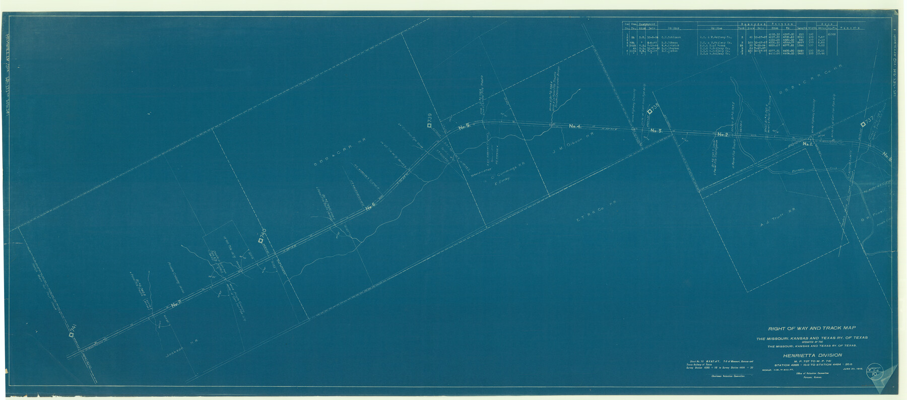
Right of Way and Track Map, The Missouri, Kansas and Texas Ry. of Texas operated by the Missouri, Kansas and Texas Ry. of Texas, Henrietta Division
M.P. 737 to M.P. 741, Station 4285+10.0 to Station 4484+20.0
Z-2-20
-
Map/Doc
64069
-
Collection
General Map Collection
-
Object Dates
1918 (Creation Date)
-
People and Organizations
Office of Valuation Committee (Publisher)
-
Counties
Montague
-
Subjects
Railroads
-
Height x Width
24.8 x 56.3 inches
63.0 x 143.0 cm
-
Medium
blueprint/diazo
-
Scale
1" = 400 feet
-
Comments
See 64065-64068 and 64070-64074 for other segments of the map. See 64064 (PDF) for the documents/letter that accompanied the map.
-
Features
MK&T
[Route] to Wichita Falls
Farmers Creek
[Route] to Denison
Public Road
Part of: General Map Collection
Flight Mission No. DQN-2K, Frame 164, Calhoun County

Print $20.00
- Digital $50.00
Flight Mission No. DQN-2K, Frame 164, Calhoun County
1953
Size 18.7 x 22.5 inches
Map/Doc 84326
Gaines County Working Sketch 9

Print $40.00
- Digital $50.00
Gaines County Working Sketch 9
1951
Size 75.2 x 20.8 inches
Map/Doc 69309
Roberts County Boundary File 2c

Print $28.00
- Digital $50.00
Roberts County Boundary File 2c
Size 9.5 x 28.3 inches
Map/Doc 58363
Flight Mission No. CON-4R, Frame 200, Stonewall County

Print $20.00
- Digital $50.00
Flight Mission No. CON-4R, Frame 200, Stonewall County
1957
Size 18.2 x 22.0 inches
Map/Doc 86994
Webb County Sketch File Z

Print $20.00
- Digital $50.00
Webb County Sketch File Z
1901
Size 16.8 x 22.2 inches
Map/Doc 12610
Uvalde County Working Sketch 26

Print $20.00
- Digital $50.00
Uvalde County Working Sketch 26
1954
Size 37.2 x 31.9 inches
Map/Doc 72096
Tyler County Sketch File 19

Print $4.00
- Digital $50.00
Tyler County Sketch File 19
Size 3.5 x 6.1 inches
Map/Doc 38670
Atascosa County Boundary File 5

Print $32.00
- Digital $50.00
Atascosa County Boundary File 5
Size 8.8 x 6.3 inches
Map/Doc 50198
Parker County Working Sketch 19-2

Print $20.00
- Digital $50.00
Parker County Working Sketch 19-2
2005
Map/Doc 83580
Flight Mission No. CRC-4R, Frame 104, Chambers County

Print $20.00
- Digital $50.00
Flight Mission No. CRC-4R, Frame 104, Chambers County
1956
Size 18.6 x 22.4 inches
Map/Doc 84901
Foard County Working Sketch 12

Print $20.00
- Digital $50.00
Foard County Working Sketch 12
1977
Size 43.4 x 36.1 inches
Map/Doc 69203
Coleman County Sketch File 9

Print $24.00
- Digital $50.00
Coleman County Sketch File 9
1859
Size 12.4 x 8.2 inches
Map/Doc 18675
You may also like
Calhoun County NRC Article 33.136 Sketch 15

Print $46.00
Calhoun County NRC Article 33.136 Sketch 15
2025
Map/Doc 97428
Nueces County Rolled Sketch M-12

Print $20.00
- Digital $50.00
Nueces County Rolled Sketch M-12
1913
Size 24.9 x 40.0 inches
Map/Doc 7171
Zavala County Working Sketch 21

Print $20.00
- Digital $50.00
Zavala County Working Sketch 21
1979
Size 23.0 x 18.0 inches
Map/Doc 62096
Dallam County Boundary File 1

Print $12.00
- Digital $50.00
Dallam County Boundary File 1
Size 9.0 x 7.6 inches
Map/Doc 52047

Harris County Working Sketch 111

Print $20.00
- Digital $50.00
Harris County Working Sketch 111
1982
Size 21.7 x 16.0 inches
Map/Doc 66003
St. Louis, Brownsville & Mexico Railway Location Map from Mile 120 to Rio Grande

Print $40.00
- Digital $50.00
St. Louis, Brownsville & Mexico Railway Location Map from Mile 120 to Rio Grande
1905
Size 20.2 x 61.4 inches
Map/Doc 64169
Gaines County Rolled Sketch 9

Print $20.00
- Digital $50.00
Gaines County Rolled Sketch 9
Size 20.9 x 29.8 inches
Map/Doc 5929
William P. White Subdivision of 2.45 Acres out of North Half of Survey 1, Block 36, Township 5 North, Dawson County, Texas

Print $20.00
- Digital $50.00
William P. White Subdivision of 2.45 Acres out of North Half of Survey 1, Block 36, Township 5 North, Dawson County, Texas
1924
Size 18.6 x 24.7 inches
Map/Doc 92575
East Part of Brewster Co.

Print $40.00
- Digital $50.00
East Part of Brewster Co.
1952
Size 48.8 x 31.9 inches
Map/Doc 1785
[Map of Texas showing Frisco Lines]
![95796, [Map of Texas showing Frisco Lines], Cobb Digital Map Collection](https://historictexasmaps.com/wmedia_w700/maps/95796.tif.jpg)
Print $20.00
- Digital $50.00
[Map of Texas showing Frisco Lines]
1910
Size 19.8 x 19.2 inches
Map/Doc 95796
Haskell County Rolled Sketch 10

Print $20.00
- Digital $50.00
Haskell County Rolled Sketch 10
1981
Size 33.2 x 14.3 inches
Map/Doc 6169