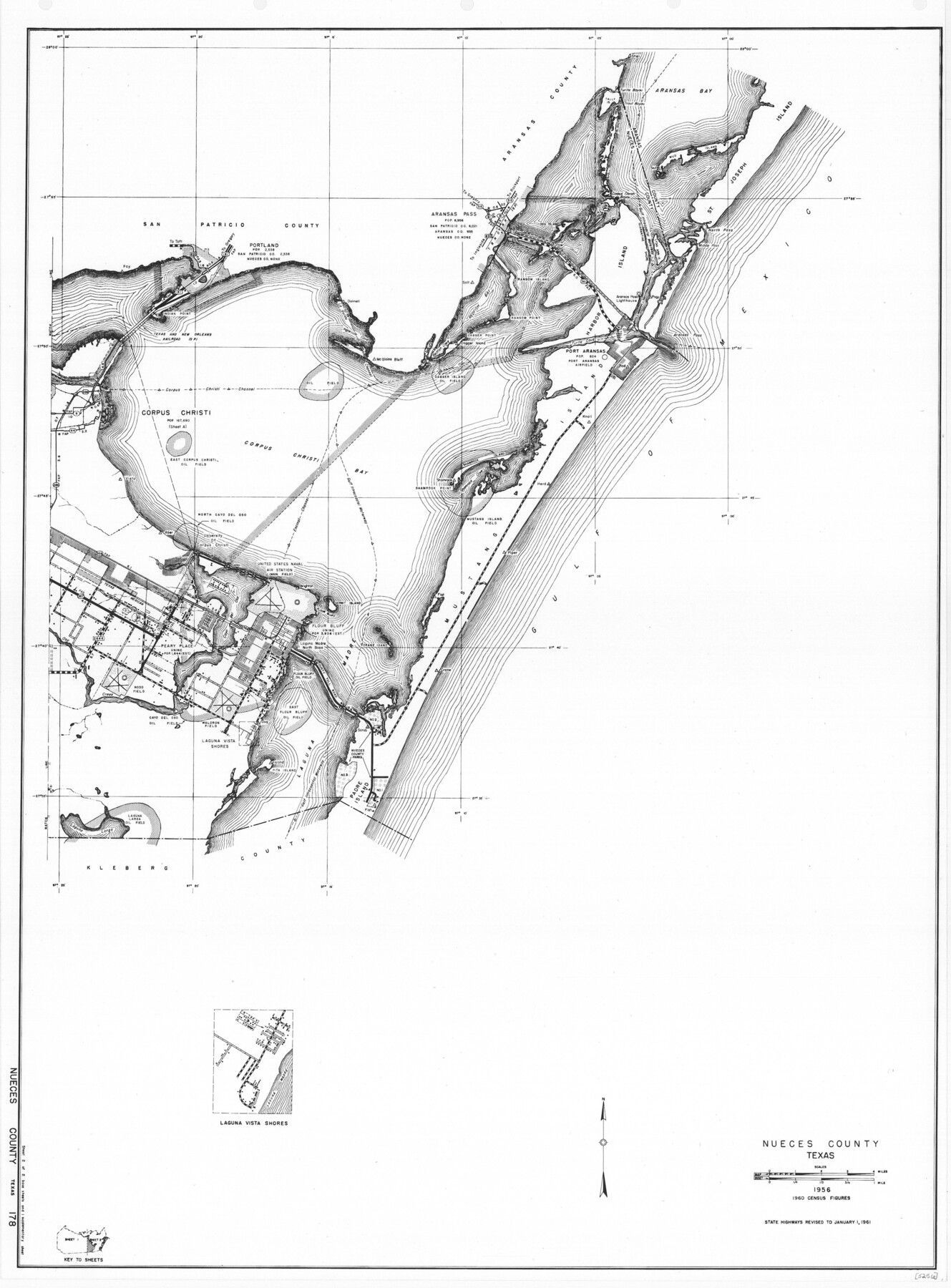
General Highway Map, Nueces County, Texas
-
Map/Doc
79616
-
Collection
Texas State Library and Archives
-
Object Dates
1961 (Creation Date)
-
People and Organizations
Texas State Highway Department (Publisher)
-
Counties
Nueces
-
Subjects
County
-
Height x Width
24.6 x 18.2 inches
62.5 x 46.2 cm
-
Comments
Prints available courtesy of the Texas State Library and Archives.
More info can be found here: TSLAC Map 05256
Part of: Texas State Library and Archives
General Highway Map, Waller County, Texas

Print $20.00
General Highway Map, Waller County, Texas
1939
Size 25.1 x 18.5 inches
Map/Doc 79270
General Highway Map, Wilbarger County, Texas

Print $20.00
General Highway Map, Wilbarger County, Texas
1940
Size 24.7 x 18.1 inches
Map/Doc 79278
General Highway Map, Atascosa County, Texas

Print $20.00
General Highway Map, Atascosa County, Texas
1961
Size 18.3 x 25.0 inches
Map/Doc 79355
General Highway Map, Palo Pinto County, Texas

Print $20.00
General Highway Map, Palo Pinto County, Texas
1940
Size 18.2 x 24.6 inches
Map/Doc 79213
General Highway Map, Motley County, Texas

Print $20.00
General Highway Map, Motley County, Texas
1961
Size 24.7 x 18.1 inches
Map/Doc 79605
General Highway Map, Coryell County, Texas

Print $20.00
General Highway Map, Coryell County, Texas
1961
Size 18.1 x 24.8 inches
Map/Doc 79422
General Highway Map, Tom Green County, Texas

Print $20.00
General Highway Map, Tom Green County, Texas
1961
Size 18.4 x 25.0 inches
Map/Doc 79678
General Highway Map, McCulloch County, Texas

Print $20.00
General Highway Map, McCulloch County, Texas
1961
Size 25.0 x 19.3 inches
Map/Doc 79588
General Highway Map. Detail of Cities and Towns in Grayson County, Texas [Denison and Sherman]
![79486, General Highway Map. Detail of Cities and Towns in Grayson County, Texas [Denison and Sherman], Texas State Library and Archives](https://historictexasmaps.com/wmedia_w700/maps/79486.tif.jpg)
Print $20.00
General Highway Map. Detail of Cities and Towns in Grayson County, Texas [Denison and Sherman]
1961
Size 18.1 x 24.6 inches
Map/Doc 79486
General Highway Map, Colorado County, Texas

Print $20.00
General Highway Map, Colorado County, Texas
1940
Size 25.1 x 18.5 inches
Map/Doc 79054
Revised Edition of Murphy and Bolanz Official Map of the City of Dallas and Suburbs

Print $20.00
Revised Edition of Murphy and Bolanz Official Map of the City of Dallas and Suburbs
1891
Size 38.1 x 30.8 inches
Map/Doc 76275
General Highway Map, Duval County, Texas

Print $20.00
General Highway Map, Duval County, Texas
1961
Size 18.1 x 24.5 inches
Map/Doc 79449
You may also like
Upton County Rolled Sketch 32

Print $20.00
- Digital $50.00
Upton County Rolled Sketch 32
Size 38.6 x 39.0 inches
Map/Doc 10049
Reagan County Working Sketch 20

Print $40.00
- Digital $50.00
Reagan County Working Sketch 20
1954
Size 37.5 x 68.2 inches
Map/Doc 71862
[Central Part of County]
![89791, [Central Part of County], Twichell Survey Records](https://historictexasmaps.com/wmedia_w700/maps/89791-1.tif.jpg)
Print $40.00
- Digital $50.00
[Central Part of County]
Size 70.0 x 26.3 inches
Map/Doc 89791
Military Reconnaissance of the Arkansas, Rio Del Norte, and Rio Gila

Print $40.00
Military Reconnaissance of the Arkansas, Rio Del Norte, and Rio Gila
1847
Size 33.3 x 72.6 inches
Map/Doc 76240
Presidio County Rolled Sketch 5

Print $20.00
- Digital $50.00
Presidio County Rolled Sketch 5
Size 23.1 x 22.2 inches
Map/Doc 7329
Presidio County Rolled Sketch 4

Print $40.00
- Digital $50.00
Presidio County Rolled Sketch 4
Size 19.1 x 69.8 inches
Map/Doc 10733
General Highway Map, Brazoria County, Texas

Print $20.00
General Highway Map, Brazoria County, Texas
1939
Size 18.6 x 25.0 inches
Map/Doc 79024
Gray County Sketch File 5

Print $16.00
- Digital $50.00
Gray County Sketch File 5
1882
Size 12.8 x 8.3 inches
Map/Doc 24418
Orange County Working Sketch 11

Print $20.00
- Digital $50.00
Orange County Working Sketch 11
1922
Size 11.9 x 14.7 inches
Map/Doc 71343
[Northeast 1/4 of County Map showing Durrell's Tie Line]
![91619, [Northeast 1/4 of County Map showing Durrell's Tie Line], Twichell Survey Records](https://historictexasmaps.com/wmedia_w700/maps/91619-1.tif.jpg)
Print $20.00
- Digital $50.00
[Northeast 1/4 of County Map showing Durrell's Tie Line]
Size 24.1 x 18.7 inches
Map/Doc 91619
The Republic County of Liberty. January 20, 1841

Print $20.00
The Republic County of Liberty. January 20, 1841
2020
Size 19.9 x 21.7 inches
Map/Doc 96209
Matagorda County Sketch File 46

Print $107.00
- Digital $50.00
Matagorda County Sketch File 46
1985
Size 11.2 x 8.5 inches
Map/Doc 30932