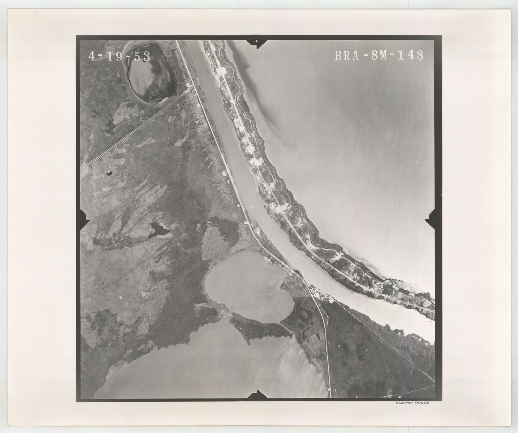
Flight Mission No. BRA-8M, Frame 148, Jefferson County
BRA-8M-148
-
Map/Doc
85640
-
Collection
General Map Collection
-
Object Dates
1953/4/19 (Creation Date)
-
People and Organizations
U. S. Department of Agriculture (Publisher)
-
Counties
Jefferson
-
Subjects
Aerial Photograph
-
Height x Width
18.8 x 22.5 inches
47.8 x 57.2 cm
-
Comments
Flown by Jack Ammann Photogrammetric Engineers of San Antonio, Texas.
Part of: General Map Collection
Culberson County Sketch File 4a

Print $10.00
- Digital $50.00
Culberson County Sketch File 4a
Size 9.2 x 7.9 inches
Map/Doc 20131
Duval County Working Sketch 48

Print $20.00
- Digital $50.00
Duval County Working Sketch 48
1981
Size 21.2 x 13.4 inches
Map/Doc 68772
Donley County Rolled Sketch 4

Print $20.00
- Digital $50.00
Donley County Rolled Sketch 4
1972
Size 16.0 x 17.4 inches
Map/Doc 5731
Set of new maps of Austin's Colony by G. Borden, Jr.

Print $20.00
- Digital $50.00
Set of new maps of Austin's Colony by G. Borden, Jr.
1833
Size 25.0 x 17.0 inches
Map/Doc 131
Comal County Sketch File 20

Print $6.00
- Digital $50.00
Comal County Sketch File 20
1857
Size 12.4 x 8.1 inches
Map/Doc 19039
Flight Mission No. BQY-4M, Frame 123, Harris County

Print $20.00
- Digital $50.00
Flight Mission No. BQY-4M, Frame 123, Harris County
1953
Size 18.7 x 22.4 inches
Map/Doc 85291
Flight Mission No. CUG-2P, Frame 22, Kleberg County

Print $20.00
- Digital $50.00
Flight Mission No. CUG-2P, Frame 22, Kleberg County
1956
Size 18.7 x 22.4 inches
Map/Doc 86186
Map of the City of Kerens (Navarro County) Texas

Print $40.00
- Digital $50.00
Map of the City of Kerens (Navarro County) Texas
1958
Size 44.2 x 54.9 inches
Map/Doc 93670
That part of the boundary between the Republic of Texas and the United States, North of Sabine River from the 36th to the 72nd Mile Mound on the Meridian Line (Sheet No. 2)

Print $20.00
- Digital $50.00
That part of the boundary between the Republic of Texas and the United States, North of Sabine River from the 36th to the 72nd Mile Mound on the Meridian Line (Sheet No. 2)
1842
Size 33.7 x 26.0 inches
Map/Doc 3132
Denton County Working Sketch 36

Print $20.00
- Digital $50.00
Denton County Working Sketch 36
2008
Size 18.5 x 29.0 inches
Map/Doc 88877
Flight Mission No. DCL-6C, Frame 5, Kenedy County

Print $20.00
- Digital $50.00
Flight Mission No. DCL-6C, Frame 5, Kenedy County
1943
Size 18.4 x 22.4 inches
Map/Doc 85865
You may also like
Gaines County Working Sketch Graphic Index

Print $40.00
- Digital $50.00
Gaines County Working Sketch Graphic Index
1956
Size 42.7 x 54.0 inches
Map/Doc 76550
Upton County Rolled Sketch 59A

Print $20.00
- Digital $50.00
Upton County Rolled Sketch 59A
Size 35.5 x 46.3 inches
Map/Doc 76424
[Sketch in Southeast Part of County around J. H. Gibson Sections 1 and 2]
![91906, [Sketch in Southeast Part of County around J. H. Gibson Sections 1 and 2], Twichell Survey Records](https://historictexasmaps.com/wmedia_w700/maps/91906-1.tif.jpg)
Print $2.00
- Digital $50.00
[Sketch in Southeast Part of County around J. H. Gibson Sections 1 and 2]
Size 14.2 x 7.3 inches
Map/Doc 91906
[W. T. Brewer: M. McDonald, Ralph Gilpin, A. Vanhooser, John Baker, John R. Taylor Surveys]
![90965, [W. T. Brewer: M. McDonald, Ralph Gilpin, A. Vanhooser, John Baker, John R. Taylor Surveys], Twichell Survey Records](https://historictexasmaps.com/wmedia_w700/maps/90965-1.tif.jpg)
Print $2.00
- Digital $50.00
[W. T. Brewer: M. McDonald, Ralph Gilpin, A. Vanhooser, John Baker, John R. Taylor Surveys]
Size 8.9 x 11.3 inches
Map/Doc 90965
Flight Mission No. DCL-6C, Frame 180, Kenedy County

Print $20.00
- Digital $50.00
Flight Mission No. DCL-6C, Frame 180, Kenedy County
1943
Size 18.5 x 22.4 inches
Map/Doc 85992
Flight Mission No. CRC-2R, Frame 177, Chambers County

Print $20.00
- Digital $50.00
Flight Mission No. CRC-2R, Frame 177, Chambers County
1956
Size 18.6 x 22.4 inches
Map/Doc 84755
Concho County Sketch File 18

Print $32.00
- Digital $50.00
Concho County Sketch File 18
1898
Size 9.1 x 4.4 inches
Map/Doc 19137

Terry County Sketch File 3

Print $20.00
- Digital $50.00
Terry County Sketch File 3
1948
Size 16.2 x 39.0 inches
Map/Doc 10390
Carte de la Louisiane et Pays Voisins Pour servir a l'Histoire Generale des Voyages

Print $20.00
Carte de la Louisiane et Pays Voisins Pour servir a l'Histoire Generale des Voyages
1757
Size 9.6 x 14.9 inches
Map/Doc 94572
Jefferson County Working Sketch 3

Print $20.00
- Digital $50.00
Jefferson County Working Sketch 3
1904
Size 25.1 x 21.2 inches
Map/Doc 66546
Jefferson County Rolled Sketch GA

Print $20.00
- Digital $50.00
Jefferson County Rolled Sketch GA
1937
Size 29.5 x 36.7 inches
Map/Doc 6437