Menard County Sketch File 22
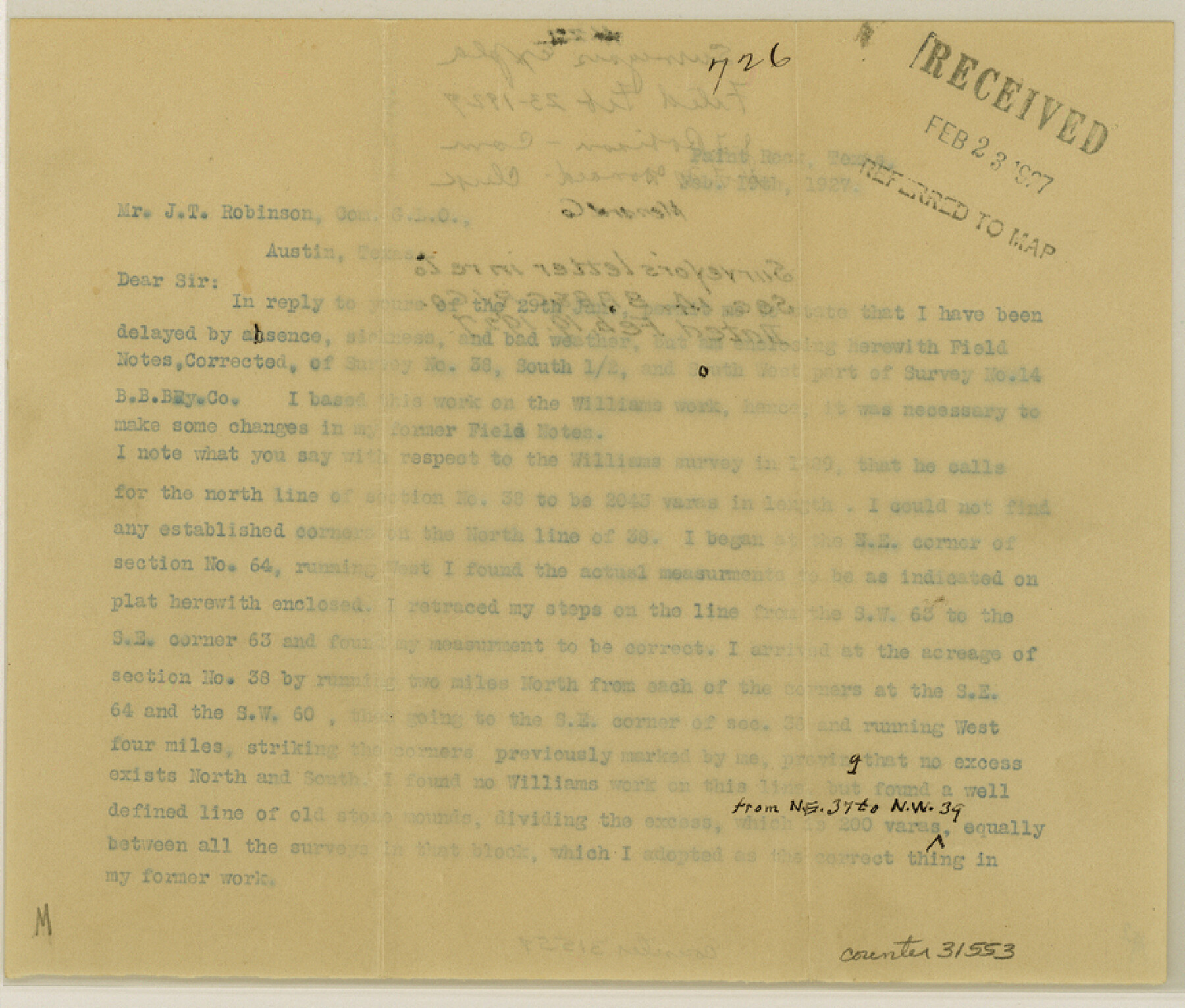
[Surveyor's letter regarding section 38, G. H. & S. A. RR. Co., and section 14, B. B. B. & C. RR. Co.]
-
Map/Doc
31553
-
Collection
General Map Collection
-
Object Dates
2/19/1927 (Creation Date)
2/23/1927 (File Date)
2/19/1927 (Correspondence Date)
-
People and Organizations
Thomas F. Jackson (Surveyor/Engineer)
-
Counties
Menard
-
Subjects
Surveying Sketch File
-
Height x Width
7.4 x 8.6 inches
18.8 x 21.8 cm
-
Medium
paper, print
-
Comments
See Menard County Sketch File 23 (12076) for sketch.
Related maps
Menard County Sketch File 23

Print $20.00
- Digital $50.00
Menard County Sketch File 23
1927
Size 21.2 x 31.1 inches
Map/Doc 12076
Part of: General Map Collection
Guadalupe County Working Sketch 6

Print $20.00
- Digital $50.00
Guadalupe County Working Sketch 6
1948
Size 24.0 x 19.7 inches
Map/Doc 63315
A Sketch of the Vice Royalty exhibiting the several Provinces and its Aproximation [sic] to the Internal Provinces of New Spain
![95157, A Sketch of the Vice Royalty exhibiting the several Provinces and its Aproximation [sic] to the Internal Provinces of New Spain, General Map Collection](https://historictexasmaps.com/wmedia_w700/maps/95157.tif.jpg)
Print $20.00
- Digital $50.00
A Sketch of the Vice Royalty exhibiting the several Provinces and its Aproximation [sic] to the Internal Provinces of New Spain
1810
Size 15.2 x 21.1 inches
Map/Doc 95157
Wilbarger County Working Sketch 2b

Print $20.00
- Digital $50.00
Wilbarger County Working Sketch 2b
1922
Size 19.8 x 20.0 inches
Map/Doc 72540
San Jacinto River and Tributaries, Texas - Survey of 1939

Print $20.00
- Digital $50.00
San Jacinto River and Tributaries, Texas - Survey of 1939
1939
Size 27.7 x 40.4 inches
Map/Doc 60306
Brewster County Sketch File N-2

Print $44.00
- Digital $50.00
Brewster County Sketch File N-2
1881
Size 8.2 x 12.8 inches
Map/Doc 15567
Bandera County Working Sketch 28

Print $20.00
- Digital $50.00
Bandera County Working Sketch 28
1953
Size 24.8 x 19.5 inches
Map/Doc 67624
Flight Mission No. BQR-9K, Frame 54, Brazoria County

Print $20.00
- Digital $50.00
Flight Mission No. BQR-9K, Frame 54, Brazoria County
1952
Size 18.5 x 22.3 inches
Map/Doc 84058
Kleberg County Rolled Sketch 10-16

Print $20.00
- Digital $50.00
Kleberg County Rolled Sketch 10-16
1952
Size 37.0 x 33.2 inches
Map/Doc 9381
Ellis County Working Sketch 5

Print $40.00
- Digital $50.00
Ellis County Working Sketch 5
1997
Size 49.2 x 32.4 inches
Map/Doc 69021
Karnes County Rolled Sketch 4

Print $20.00
- Digital $50.00
Karnes County Rolled Sketch 4
1961
Size 33.4 x 37.7 inches
Map/Doc 9667
Hudspeth County Sketch File 26

Print $20.00
- Digital $50.00
Hudspeth County Sketch File 26
Size 42.5 x 23.9 inches
Map/Doc 10496
The Dawn of Humans Peopling of the Americas

The Dawn of Humans Peopling of the Americas
2000
Size 31.3 x 20.5 inches
Map/Doc 96841
You may also like
South Part Pecos County

Print $20.00
- Digital $50.00
South Part Pecos County
1976
Size 36.8 x 44.2 inches
Map/Doc 73262
El Paso County Boundary File 12

Print $16.00
- Digital $50.00
El Paso County Boundary File 12
Size 13.9 x 8.5 inches
Map/Doc 53153
Guadalupe County Sketch File 21

Print $6.00
- Digital $50.00
Guadalupe County Sketch File 21
Size 9.9 x 8.5 inches
Map/Doc 24702
Nueces County Rolled Sketch 50

Print $20.00
- Digital $50.00
Nueces County Rolled Sketch 50
1939
Size 21.9 x 38.0 inches
Map/Doc 9605
Comanche County Sketch File 20

Print $40.00
- Digital $50.00
Comanche County Sketch File 20
Size 15.5 x 12.6 inches
Map/Doc 19103
Milam County Boundary File 2a

Print $10.00
- Digital $50.00
Milam County Boundary File 2a
Size 10.6 x 8.0 inches
Map/Doc 57208
Terrell County

Print $40.00
- Digital $50.00
Terrell County
1931
Size 48.5 x 40.5 inches
Map/Doc 73300
Val Verde County Working Sketch 97

Print $20.00
- Digital $50.00
Val Verde County Working Sketch 97
1980
Size 41.7 x 47.6 inches
Map/Doc 72232
Brewster County Sketch File N-8

Print $12.00
- Digital $50.00
Brewster County Sketch File N-8
1914
Size 10.8 x 8.6 inches
Map/Doc 15610
Crosby County Sketch File 24

Print $4.00
- Digital $50.00
Crosby County Sketch File 24
Size 7.3 x 8.8 inches
Map/Doc 20091
