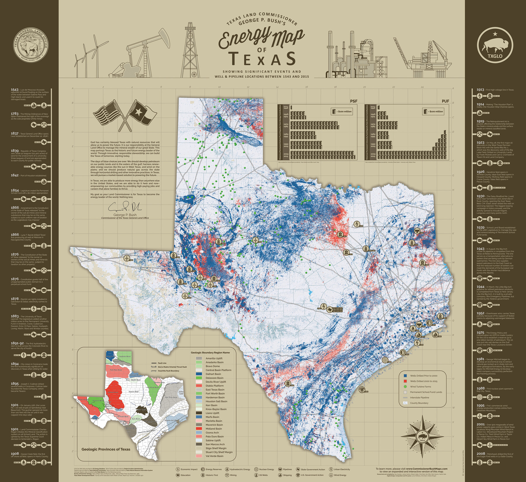
Texas Land Commissioner George P. Bush's Energy Map of Texas Showing Significant Events and Well & Pipeline Locations Between 1543 and 2015
-
Map/Doc
93978
-
Collection
General Map Collection
-
Object Dates
2015 (Creation Date)
2016/1/12 (File Date)
-
People and Organizations
Texas General Land Office (Publisher)
James Harkins (Compiler)
Robert Hatter (Compiler)
Ken Mills (Compiler)
Mark Havens (Compiler)
Hector Valle (Compiler)
Lance McIhany (Draftsman)
Chris Elam (Draftsman)
Andrea Morgan (Draftsman)
Chris Elam (Compiler)
Alex Sanders (Compiler)
-
Subjects
Energy Offshore Submerged Area Energy Surface State of Texas
-
Height x Width
33.3 x 36.3 inches
84.6 x 92.2 cm
-
Medium
paper, print
-
Comments
See this StoryMap for an online, interactive overview of energy in Texas.
-
URLs
https://medium.com/save-texas-history/texas-land-commissioner-george-p-329309c25468#.i98naw56e
Part of: General Map Collection
Webb County Working Sketch 92

Print $20.00
- Digital $50.00
Webb County Working Sketch 92
1988
Size 30.6 x 37.0 inches
Map/Doc 72459
Fractional Township No. 10 South Range No. 27 East of the Indian Meridian, Indian Territory

Print $20.00
- Digital $50.00
Fractional Township No. 10 South Range No. 27 East of the Indian Meridian, Indian Territory
1897
Size 19.2 x 24.3 inches
Map/Doc 75246
Leon County Rolled Sketch 6

Print $20.00
- Digital $50.00
Leon County Rolled Sketch 6
1951
Size 31.6 x 37.6 inches
Map/Doc 6597
Real County Working Sketch 26

Print $20.00
- Digital $50.00
Real County Working Sketch 26
1947
Size 28.7 x 28.1 inches
Map/Doc 71918
Starr County Rolled Sketch 17

Print $20.00
- Digital $50.00
Starr County Rolled Sketch 17
1911
Size 26.4 x 23.1 inches
Map/Doc 7802
Crane County Rolled Sketch 5A

Print $20.00
- Digital $50.00
Crane County Rolled Sketch 5A
1927
Size 38.0 x 46.4 inches
Map/Doc 8678
[Photostats of section of Hydrographic Surveys H-5399, H-4822 and H-470, Mouth of Trinity River]
![61154, [Photostats of section of Hydrographic Surveys H-5399, H-4822 and H-470, Mouth of Trinity River], General Map Collection](https://historictexasmaps.com/wmedia_w700/maps/61154.tif.jpg)
Print $20.00
- Digital $50.00
[Photostats of section of Hydrographic Surveys H-5399, H-4822 and H-470, Mouth of Trinity River]
1933
Size 18.2 x 25.8 inches
Map/Doc 61154
Travis County Appraisal District Plat Map 1_0100

Print $20.00
- Digital $50.00
Travis County Appraisal District Plat Map 1_0100
Size 21.6 x 26.4 inches
Map/Doc 94205
Kendall County Working Sketch 10

Print $20.00
- Digital $50.00
Kendall County Working Sketch 10
1954
Size 21.2 x 24.9 inches
Map/Doc 66682
Flight Mission No. CUG-1P, Frame 48, Kleberg County

Print $20.00
- Digital $50.00
Flight Mission No. CUG-1P, Frame 48, Kleberg County
1956
Size 18.5 x 22.3 inches
Map/Doc 86126
Motley County Sketch File 28 (S)

Print $4.00
- Digital $50.00
Motley County Sketch File 28 (S)
Size 8.8 x 7.9 inches
Map/Doc 32211
Bosque County Working Sketch 29

Print $20.00
- Digital $50.00
Bosque County Working Sketch 29
2009
Size 35.9 x 40.6 inches
Map/Doc 88997
You may also like
Tyler County Working Sketch Graphic Index

Print $20.00
- Digital $50.00
Tyler County Working Sketch Graphic Index
1944
Size 47.4 x 39.6 inches
Map/Doc 76719
Presidio County Working Sketch 146

Print $20.00
- Digital $50.00
Presidio County Working Sketch 146
1989
Size 20.7 x 20.6 inches
Map/Doc 71824
Runnels County Working Sketch 9

Print $40.00
- Digital $50.00
Runnels County Working Sketch 9
1948
Size 48.9 x 27.9 inches
Map/Doc 63605
Calhoun County Sketch File 4

Print $14.00
- Digital $50.00
Calhoun County Sketch File 4
1908
Size 11.0 x 6.9 inches
Map/Doc 35901
Goliad County Sketch File 30

Print $40.00
- Digital $50.00
Goliad County Sketch File 30
Size 13.0 x 15.0 inches
Map/Doc 24327
Cooke County Sketch File 42

Print $8.00
- Digital $50.00
Cooke County Sketch File 42
1940
Size 14.3 x 8.8 inches
Map/Doc 19316
Kimble County

Print $40.00
- Digital $50.00
Kimble County
1890
Size 37.4 x 58.6 inches
Map/Doc 16866
Gillespie County

Print $40.00
- Digital $50.00
Gillespie County
1887
Size 34.6 x 49.8 inches
Map/Doc 66836
Victoria County Working Sketch 1

Print $20.00
- Digital $50.00
Victoria County Working Sketch 1
1938
Size 33.5 x 36.9 inches
Map/Doc 72271
Chambers County Sketch File 23

Print $2.00
- Digital $50.00
Chambers County Sketch File 23
1878
Size 10.0 x 7.9 inches
Map/Doc 17597
Mason County Sketch File 7

Print $4.00
- Digital $50.00
Mason County Sketch File 7
Size 7.9 x 8.8 inches
Map/Doc 30689
Upshur County Sketch File 2a

Print $4.00
- Digital $50.00
Upshur County Sketch File 2a
Size 12.9 x 8.2 inches
Map/Doc 38734