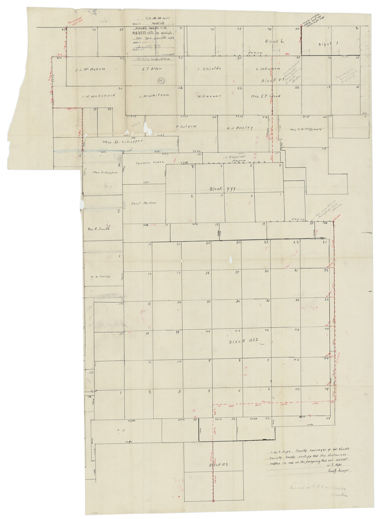
Val Verde County Sketch File 29
[Sketch of surveys in the vicinity of Blocks AZ2 and YYY northeast from Del Rio near the eastern boundary line of the county]
-
Map/Doc
76760
-
Collection
General Map Collection
-
Object Dates
2/20/1933 (File Date)
-
People and Organizations
W.T. Hope (Surveyor/Engineer)
-
Counties
Val Verde
-
Subjects
Surveying Sketch File
-
Height x Width
33.1 x 23.8 inches
84.1 x 60.5 cm
-
Medium
paper, manuscript
Part of: General Map Collection
Medina County Sketch File 13

Print $20.00
- Digital $50.00
Medina County Sketch File 13
Size 18.1 x 22.7 inches
Map/Doc 12069
PSL Field Notes for Block CS in Dallam County

PSL Field Notes for Block CS in Dallam County
Map/Doc 81649
Duval County Sketch File 58

Print $20.00
- Digital $50.00
Duval County Sketch File 58
1940
Size 18.3 x 19.0 inches
Map/Doc 11406
King County Sketch File 4

Print $22.00
- Digital $50.00
King County Sketch File 4
Size 8.8 x 14.2 inches
Map/Doc 29022
Culberson County Working Sketch 53

Print $20.00
- Digital $50.00
Culberson County Working Sketch 53
1974
Size 43.3 x 32.8 inches
Map/Doc 68507
Lavaca County Rolled Sketch 5

Print $40.00
- Digital $50.00
Lavaca County Rolled Sketch 5
Size 37.0 x 49.1 inches
Map/Doc 10288
Brazos River, Clodine Sheet

Print $4.00
- Digital $50.00
Brazos River, Clodine Sheet
1930
Size 21.8 x 24.6 inches
Map/Doc 65287
Val Verde County Rolled Sketch 49

Print $20.00
- Digital $50.00
Val Verde County Rolled Sketch 49
Size 26.9 x 34.3 inches
Map/Doc 8120
Flight Mission No. DQN-2K, Frame 158, Calhoun County

Print $20.00
- Digital $50.00
Flight Mission No. DQN-2K, Frame 158, Calhoun County
1953
Size 18.4 x 22.3 inches
Map/Doc 84320
Howard County Sketch File 4

Print $20.00
- Digital $50.00
Howard County Sketch File 4
Size 25.6 x 21.8 inches
Map/Doc 11793
[Cotton Belt, St. Louis Southwestern Railway of Texas, Alignment through Smith County]
![64375, [Cotton Belt, St. Louis Southwestern Railway of Texas, Alignment through Smith County], General Map Collection](https://historictexasmaps.com/wmedia_w700/maps/64375.tif.jpg)
Print $20.00
- Digital $50.00
[Cotton Belt, St. Louis Southwestern Railway of Texas, Alignment through Smith County]
1903
Size 21.3 x 28.5 inches
Map/Doc 64375
Flight Mission No. DCL-6C, Frame 78, Kenedy County

Print $20.00
- Digital $50.00
Flight Mission No. DCL-6C, Frame 78, Kenedy County
1943
Size 17.5 x 20.7 inches
Map/Doc 85920
You may also like
Flight Mission No. DQO-3K, Frame 29, Galveston County

Print $20.00
- Digital $50.00
Flight Mission No. DQO-3K, Frame 29, Galveston County
1952
Size 18.8 x 22.4 inches
Map/Doc 85070
Flight Mission No. CRC-4R, Frame 95, Chambers County

Print $20.00
- Digital $50.00
Flight Mission No. CRC-4R, Frame 95, Chambers County
1956
Size 18.6 x 22.3 inches
Map/Doc 84892
Reeves County Boundary File 81 1/2

Print $54.00
- Digital $50.00
Reeves County Boundary File 81 1/2
Size 9.7 x 8.3 inches
Map/Doc 58216
Childress County Sketch File 21

Print $10.00
- Digital $50.00
Childress County Sketch File 21
1896
Size 9.1 x 5.8 inches
Map/Doc 18298
Garza County Sketch File 3

Print $20.00
- Digital $50.00
Garza County Sketch File 3
1879
Size 18.6 x 17.6 inches
Map/Doc 11544
Subdivisions of Capitol Leagues 93, 94, 95, 96, 104, 105, 106, 107, 116, 117, 118, 127, 128, 129, 130, 131, 132, 140, 141, 142 and parts of 75, 83, 84, 85, 86, 108, 143, 144, 145

Print $20.00
- Digital $50.00
Subdivisions of Capitol Leagues 93, 94, 95, 96, 104, 105, 106, 107, 116, 117, 118, 127, 128, 129, 130, 131, 132, 140, 141, 142 and parts of 75, 83, 84, 85, 86, 108, 143, 144, 145
1906
Size 16.7 x 26.7 inches
Map/Doc 90650
Baylor County Sketch File 25

Print $46.00
- Digital $50.00
Baylor County Sketch File 25
1954
Size 11.5 x 9.0 inches
Map/Doc 14212
Galveston Bay

Print $20.00
- Digital $50.00
Galveston Bay
1907
Size 40.6 x 34.4 inches
Map/Doc 69871
Hudspeth County Working Sketch 50

Print $20.00
- Digital $50.00
Hudspeth County Working Sketch 50
Size 24.6 x 37.2 inches
Map/Doc 66335
Webb County Sketch File 7-2

Print $20.00
- Digital $50.00
Webb County Sketch File 7-2
1927
Size 31.6 x 23.7 inches
Map/Doc 12618
Smith County Sketch File 18

Print $42.00
- Digital $50.00
Smith County Sketch File 18
1850
Size 24.8 x 19.3 inches
Map/Doc 76752
Falls County Sketch File 2

Print $4.00
- Digital $50.00
Falls County Sketch File 2
1854
Size 13.1 x 8.3 inches
Map/Doc 22332