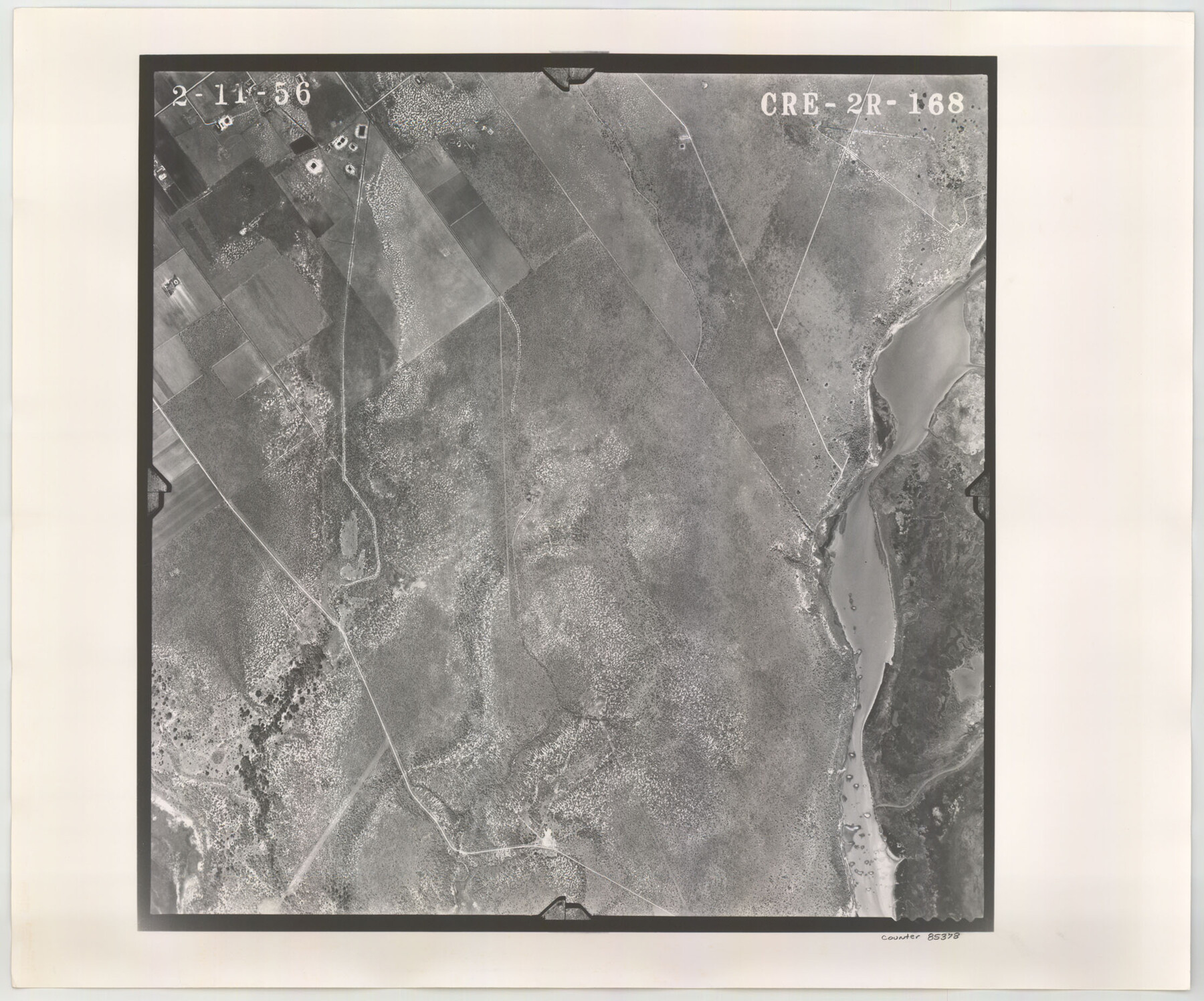
Flight Mission No. CRE-2R, Frame 168, Jackson County
CRE-2R-168
-
Map/Doc
85378
-
Collection
General Map Collection
-
Object Dates
1956/2/11 (Creation Date)
-
People and Organizations
U. S. Department of Agriculture (Publisher)
-
Counties
Jackson
-
Subjects
Aerial Photograph
-
Height x Width
18.5 x 22.3 inches
47.0 x 56.6 cm
-
Comments
Flown by Jack Ammann Photogrammetric Engineers of San Antonio, Texas.
Part of: General Map Collection
Flight Mission No. BRE-1P, Frame 95, Nueces County

Print $20.00
- Digital $50.00
Flight Mission No. BRE-1P, Frame 95, Nueces County
1956
Size 18.4 x 22.2 inches
Map/Doc 86666
Orange County Rolled Sketch 12

Print $20.00
- Digital $50.00
Orange County Rolled Sketch 12
Size 23.6 x 19.2 inches
Map/Doc 7179
Map of Ellis Farm Unit, Texas Department of Corrections, Walker County, Texas

Print $20.00
- Digital $50.00
Map of Ellis Farm Unit, Texas Department of Corrections, Walker County, Texas
Size 36.3 x 27.1 inches
Map/Doc 2284
Coke County Rolled Sketch 14B

Print $20.00
- Digital $50.00
Coke County Rolled Sketch 14B
Size 16.3 x 19.3 inches
Map/Doc 5516
Lynn County Rolled Sketch 10

Print $20.00
- Digital $50.00
Lynn County Rolled Sketch 10
Size 13.1 x 18.5 inches
Map/Doc 6646
Jackson County Rolled Sketch 13

Print $92.00
- Digital $50.00
Jackson County Rolled Sketch 13
1975
Size 10.7 x 15.3 inches
Map/Doc 46135
Hopkins County Working Sketch 1

Print $20.00
- Digital $50.00
Hopkins County Working Sketch 1
1951
Size 24.1 x 19.0 inches
Map/Doc 66226
Burnet County Working Sketch 6

Print $20.00
- Digital $50.00
Burnet County Working Sketch 6
1958
Size 20.5 x 31.0 inches
Map/Doc 67849
Tarrant County Sketch File 10

Print $8.00
- Digital $50.00
Tarrant County Sketch File 10
1859
Size 12.9 x 8.4 inches
Map/Doc 37694
Flight Mission No. CGI-3N, Frame 76, Cameron County

Print $20.00
- Digital $50.00
Flight Mission No. CGI-3N, Frame 76, Cameron County
1954
Size 18.5 x 22.1 inches
Map/Doc 84570
Austin County Rolled Sketch 5B

Print $40.00
- Digital $50.00
Austin County Rolled Sketch 5B
Size 23.7 x 51.5 inches
Map/Doc 5107
Andrews County Working Sketch 2

Print $20.00
- Digital $50.00
Andrews County Working Sketch 2
1949
Size 23.2 x 23.7 inches
Map/Doc 67048
You may also like
Lavaca County Working Sketch 18

Print $20.00
- Digital $50.00
Lavaca County Working Sketch 18
1979
Size 37.0 x 20.3 inches
Map/Doc 70371
North end of Brazos Island

Print $20.00
- Digital $50.00
North end of Brazos Island
Size 26.0 x 18.2 inches
Map/Doc 72916
Northeast Part Presidio County

Print $20.00
- Digital $50.00
Northeast Part Presidio County
1973
Size 39.6 x 31.3 inches
Map/Doc 77398
Childress County Rolled Sketch 9E

Print $20.00
- Digital $50.00
Childress County Rolled Sketch 9E
Size 23.8 x 16.6 inches
Map/Doc 78460
King County Sketch File 7A

Print $28.00
- Digital $50.00
King County Sketch File 7A
1902
Size 22.1 x 34.7 inches
Map/Doc 11936
The Chief Justice Counties. Late Summer 1837

Print $20.00
The Chief Justice Counties. Late Summer 1837
2020
Size 16.8 x 19.1 inches
Map/Doc 96079
[Galveston, Harrisburg & San Antonio Railway]
![64408, [Galveston, Harrisburg & San Antonio Railway], General Map Collection](https://historictexasmaps.com/wmedia_w700/maps/64408.tif.jpg)
Print $20.00
- Digital $50.00
[Galveston, Harrisburg & San Antonio Railway]
1892
Size 13.5 x 33.6 inches
Map/Doc 64408
Red River County Working Sketch 35

Print $20.00
- Digital $50.00
Red River County Working Sketch 35
1964
Size 34.9 x 41.0 inches
Map/Doc 72018
Montgomery County Texas Historical Map

Montgomery County Texas Historical Map
Size 23.2 x 35.5 inches
Map/Doc 94403
Map of Asia engraved to illustrate Mitchell's new intermediate geography (Inset: Map of Palestine or the Holy Land)

Print $20.00
- Digital $50.00
Map of Asia engraved to illustrate Mitchell's new intermediate geography (Inset: Map of Palestine or the Holy Land)
1885
Size 9.0 x 12.2 inches
Map/Doc 93529
Lamar [County]
![3787, Lamar [County], General Map Collection](https://historictexasmaps.com/wmedia_w700/maps/3787.tif.jpg)
Print $40.00
- Digital $50.00
Lamar [County]
1889
Size 48.2 x 35.7 inches
Map/Doc 3787
Duval County Boundary File 1

Print $26.00
- Digital $50.00
Duval County Boundary File 1
Size 8.4 x 3.7 inches
Map/Doc 52657