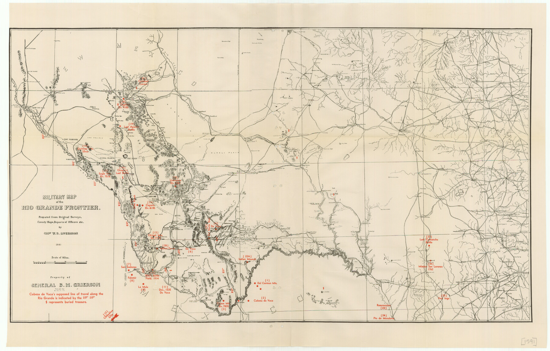
Military Map of the Rio Grande Frontier Prepared from Original Surveys, County Maps, Reports of Officers, etc
-
Map/Doc
76242
-
Collection
Texas State Library and Archives
-
Object Dates
1883 (Creation Date)
-
People and Organizations
W.R. Livermore (Surveyor/Engineer)
-
Subjects
Military
-
Height x Width
17.4 x 27.3 inches
44.2 x 69.3 cm
-
Comments
Prints available courtesy of the Texas State Library and Archives.
More info can be found here: TSLAC Map 01591
Part of: Texas State Library and Archives
General Highway Map. Detail of Cities of Towns in Bosque County, Texas

Print $20.00
General Highway Map. Detail of Cities of Towns in Bosque County, Texas
1961
Size 18.2 x 24.9 inches
Map/Doc 79379
General Highway Map, Galveston County, Texas

Print $20.00
General Highway Map, Galveston County, Texas
1939
Size 18.5 x 25.0 inches
Map/Doc 79096

General Highway Map, Panola County, Texas

Print $20.00
General Highway Map, Panola County, Texas
1961
Size 18.1 x 24.5 inches
Map/Doc 79624
General Highway Map, Liberty County, Texas

Print $20.00
General Highway Map, Liberty County, Texas
1961
Size 18.1 x 24.6 inches
Map/Doc 79571
General Highway Map, Hemphill County, Texas

Print $20.00
General Highway Map, Hemphill County, Texas
1961
Size 18.3 x 24.6 inches
Map/Doc 79515
A New Map of Texas with the Contiguous American & Mexican States

Print $20.00
A New Map of Texas with the Contiguous American & Mexican States
1835
Size 13.5 x 16.1 inches
Map/Doc 76185
Map of the Texas and Pacific Railway and Connections

Print $20.00
Map of the Texas and Pacific Railway and Connections
1897
Size 17.6 x 36.3 inches
Map/Doc 76299
General Highway Map, Waller County, Texas

Print $20.00
General Highway Map, Waller County, Texas
1939
Size 25.1 x 18.5 inches
Map/Doc 79270
General Highway Map, San Jacinto County, Texas

Print $20.00
General Highway Map, San Jacinto County, Texas
1940
Size 24.9 x 18.4 inches
Map/Doc 79236
General Highway Map, Bexar County, Texas

Print $20.00
General Highway Map, Bexar County, Texas
1961
Size 18.3 x 25.0 inches
Map/Doc 79371
General Highway Map. Detail of Cities and Towns in Williamson County, Texas [Round Rock, Taylor, Georgetown]
![79714, General Highway Map. Detail of Cities and Towns in Williamson County, Texas [Round Rock, Taylor, Georgetown], Texas State Library and Archives](https://historictexasmaps.com/wmedia_w700/maps/79714.tif.jpg)
Print $20.00
General Highway Map. Detail of Cities and Towns in Williamson County, Texas [Round Rock, Taylor, Georgetown]
1961
Size 18.2 x 24.8 inches
Map/Doc 79714
You may also like
Lubbock County Working Sketch 8

Print $20.00
- Digital $50.00
Lubbock County Working Sketch 8
1989
Size 27.4 x 25.2 inches
Map/Doc 70668
Tom Green County Working Sketch 3

Print $20.00
- Digital $50.00
Tom Green County Working Sketch 3
1933
Size 47.5 x 40.2 inches
Map/Doc 69372
The Land Offices. No. 1, Red River, December 22, 1836

Print $20.00
The Land Offices. No. 1, Red River, December 22, 1836
2020
Size 13.7 x 21.7 inches
Map/Doc 96414
Presidio County Sketch File 51

Print $20.00
- Digital $50.00
Presidio County Sketch File 51
1920
Size 17.7 x 14.0 inches
Map/Doc 11716
Haskell County Sketch File 13

Print $37.00
- Digital $50.00
Haskell County Sketch File 13
Size 8.1 x 4.0 inches
Map/Doc 26142
Hall County Rolled Sketch 3

Print $20.00
- Digital $50.00
Hall County Rolled Sketch 3
1890
Size 12.6 x 22.6 inches
Map/Doc 6048
Atascosa County Boundary File 5

Print $32.00
- Digital $50.00
Atascosa County Boundary File 5
Size 8.8 x 6.3 inches
Map/Doc 50198
Wharton County Working Sketch 25

Print $20.00
- Digital $50.00
Wharton County Working Sketch 25
1993
Size 20.0 x 25.5 inches
Map/Doc 72489

Smith County Working Sketch 5

Print $20.00
- Digital $50.00
Smith County Working Sketch 5
1932
Size 32.2 x 22.4 inches
Map/Doc 63890
Railroad Track Map, H&TCRRCo., Falls County, Texas

Print $4.00
- Digital $50.00
Railroad Track Map, H&TCRRCo., Falls County, Texas
1918
Size 11.4 x 18.7 inches
Map/Doc 62849
Map showing the environs of Brazos Islnd., Texas

Print $20.00
- Digital $50.00
Map showing the environs of Brazos Islnd., Texas
1864
Size 27.1 x 18.2 inches
Map/Doc 72990