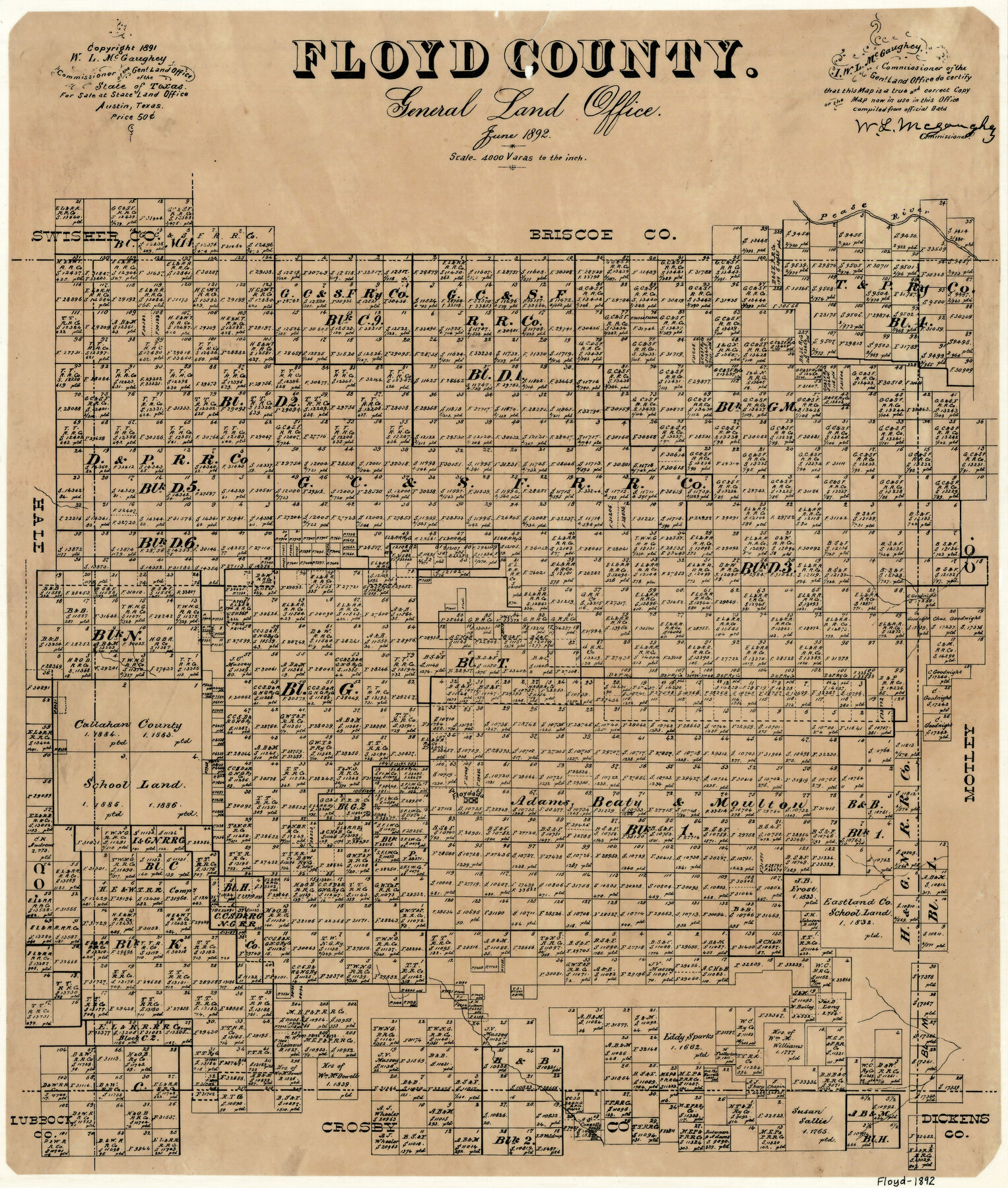
Floyd County
-
Map/Doc
3545
-
Collection
General Map Collection
-
Object Dates
6/1892 (Creation Date)
-
People and Organizations
W.L. McGaughey (GLO Commissioner)
-
Counties
Floyd
-
Subjects
County
-
Height x Width
20.8 x 17.9 inches
52.8 x 45.5 cm
-
Comments
Copyrighted 1891.
-
Features
Pease River
Floydada
Part of: General Map Collection
Orange County Sketch File 34

Print $20.00
- Digital $50.00
Orange County Sketch File 34
1929
Size 23.5 x 27.7 inches
Map/Doc 12126
Flight Mission No. CRC-4R, Frame 95, Chambers County

Print $20.00
- Digital $50.00
Flight Mission No. CRC-4R, Frame 95, Chambers County
1956
Size 18.6 x 22.3 inches
Map/Doc 84892
Gillespie County Sketch File 14

Print $6.00
- Digital $50.00
Gillespie County Sketch File 14
1880
Size 10.1 x 11.4 inches
Map/Doc 24155
Coleman County Sketch File 32

Print $4.00
- Digital $50.00
Coleman County Sketch File 32
Size 12.8 x 8.4 inches
Map/Doc 18723
Current Miscellaneous File 35

Print $10.00
- Digital $50.00
Current Miscellaneous File 35
Size 14.2 x 8.7 inches
Map/Doc 73947
Nueces County NRC Article 33.136 Sketch 5

Print $48.00
- Digital $50.00
Nueces County NRC Article 33.136 Sketch 5
2002
Size 22.9 x 34.7 inches
Map/Doc 78666
Flight Mission No. DQN-2K, Frame 50, Calhoun County

Print $20.00
- Digital $50.00
Flight Mission No. DQN-2K, Frame 50, Calhoun County
1953
Size 18.5 x 22.1 inches
Map/Doc 84255
Presidio County Sketch File 19a

Print $4.00
- Digital $50.00
Presidio County Sketch File 19a
1886
Size 13.8 x 8.8 inches
Map/Doc 34452
San Augustine County Working Sketch 11b

Print $20.00
- Digital $50.00
San Augustine County Working Sketch 11b
Size 18.9 x 26.3 inches
Map/Doc 63699
Map of Armstrong Co.

Print $20.00
- Digital $50.00
Map of Armstrong Co.
1897
Size 38.2 x 34.8 inches
Map/Doc 3246
Sketch of the route taken by a scouting party from Phantom Hill to Double Mountain, Texas

Print $20.00
- Digital $50.00
Sketch of the route taken by a scouting party from Phantom Hill to Double Mountain, Texas
1852
Size 25.3 x 13.4 inches
Map/Doc 2006
Brazoria County NRC Article 33.136 Location Key Sheet

Print $20.00
- Digital $50.00
Brazoria County NRC Article 33.136 Location Key Sheet
1964
Size 27.0 x 22.0 inches
Map/Doc 77008
You may also like
General Highway Map, Willacy County, Texas

Print $20.00
General Highway Map, Willacy County, Texas
1961
Size 18.2 x 24.7 inches
Map/Doc 79711
Gaines County Working Sketch 11

Print $40.00
- Digital $50.00
Gaines County Working Sketch 11
1953
Size 68.4 x 33.4 inches
Map/Doc 69311
Val Verde County Rolled Sketch 69A

Print $40.00
- Digital $50.00
Val Verde County Rolled Sketch 69A
1942
Size 11.0 x 139.1 inches
Map/Doc 10086
General Highway Map, Milam County, Texas

Print $20.00
General Highway Map, Milam County, Texas
1961
Size 18.1 x 24.6 inches
Map/Doc 79597
San Saba County Sketch File 5

Print $4.00
- Digital $50.00
San Saba County Sketch File 5
Size 12.8 x 8.0 inches
Map/Doc 36412
Map of Surveys Made for the T&PRRCo in Howard, Mitchell & Tom Green Counties, Blocks 27, 28, 29, 30, 31, 32 & 33, Reserve West of the Colorado

Print $40.00
- Digital $50.00
Map of Surveys Made for the T&PRRCo in Howard, Mitchell & Tom Green Counties, Blocks 27, 28, 29, 30, 31, 32 & 33, Reserve West of the Colorado
1876
Size 42.0 x 51.0 inches
Map/Doc 2228
Bee County Sketch File 7

Print $8.00
- Digital $50.00
Bee County Sketch File 7
1873
Size 10.1 x 8.0 inches
Map/Doc 14275
Flight Mission No. DAG-16K, Frame 72, Matagorda County

Print $20.00
- Digital $50.00
Flight Mission No. DAG-16K, Frame 72, Matagorda County
1952
Size 16.5 x 16.4 inches
Map/Doc 86318
Camp County, Texas

Print $3.00
- Digital $50.00
Camp County, Texas
1879
Size 9.6 x 16.8 inches
Map/Doc 512
[B. S. & F. Block 1 and A. B. & M. Block 2]
![91815, [B. S. & F. Block 1 and A. B. & M. Block 2], Twichell Survey Records](https://historictexasmaps.com/wmedia_w700/maps/91815-1.tif.jpg)
Print $20.00
- Digital $50.00
[B. S. & F. Block 1 and A. B. & M. Block 2]
Size 14.0 x 21.5 inches
Map/Doc 91815

Lubbock County Rolled Sketch 7

Print $20.00
- Digital $50.00
Lubbock County Rolled Sketch 7
1944
Size 25.8 x 32.9 inches
Map/Doc 6643