Webb County Sketch File 73
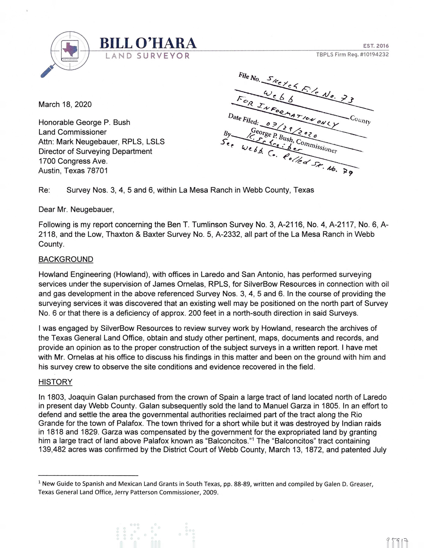
[Surveyor's report concerning Ben T. Tumlinson survey no. 3, A-2116, no. 4, A-2117, no. 6, A-2118 and the Low, Thaxton & Baxter survey no. 5, A-2332, all part of La Mesa Ranch]
-
Map/Doc
95917
-
Collection
General Map Collection
-
Object Dates
3/18/2020 (Creation Date)
7/29/2020 (File Date)
-
People and Organizations
Bill O'Hara (Surveyor/Engineer)
-
Counties
Webb
-
Subjects
Surveying Sketch File
-
Height x Width
11.0 x 8.5 inches
27.9 x 21.6 cm
-
Medium
paper, print
-
Comments
Filed for information only. See Webb County Rolled Sketch 79 (95916) for report.
Related maps
Webb County Rolled Sketch 79

Print $20.00
- Digital $50.00
Webb County Rolled Sketch 79
2020
Size 35.7 x 24.9 inches
Map/Doc 95916
Part of: General Map Collection
Flight Mission No. DQN-6K, Frame 69, Calhoun County

Print $20.00
- Digital $50.00
Flight Mission No. DQN-6K, Frame 69, Calhoun County
1953
Size 18.6 x 22.1 inches
Map/Doc 84441
Map of Tom Green County

Print $40.00
- Digital $50.00
Map of Tom Green County
1892
Size 43.2 x 48.3 inches
Map/Doc 63070
Roberts County Working Sketch 40

Print $20.00
- Digital $50.00
Roberts County Working Sketch 40
1978
Size 26.6 x 22.6 inches
Map/Doc 63566
Baylor County Sketch File 14

Print $4.00
- Digital $50.00
Baylor County Sketch File 14
1879
Size 13.0 x 8.2 inches
Map/Doc 14181
Map of Wilbarger County

Print $40.00
- Digital $50.00
Map of Wilbarger County
1887
Size 52.2 x 47.0 inches
Map/Doc 16926
Map of Wichita County Young Land District, formerly Fannin Land District

Print $20.00
- Digital $50.00
Map of Wichita County Young Land District, formerly Fannin Land District
1859
Size 22.4 x 20.5 inches
Map/Doc 4141
Lee County Working Sketch 17

Print $20.00
- Digital $50.00
Lee County Working Sketch 17
1988
Size 31.8 x 32.2 inches
Map/Doc 70396
Cooke County Working Sketch 4

Print $20.00
- Digital $50.00
Cooke County Working Sketch 4
1926
Size 23.5 x 17.6 inches
Map/Doc 68241
Louisiana and Texas Intracoastal Waterway

Print $20.00
- Digital $50.00
Louisiana and Texas Intracoastal Waterway
1937
Size 13.7 x 19.6 inches
Map/Doc 83348
Houston County Sketch File 31

Print $2.00
- Digital $50.00
Houston County Sketch File 31
1888
Size 9.1 x 7.9 inches
Map/Doc 26808
Bee County Working Sketch 18

Print $20.00
- Digital $50.00
Bee County Working Sketch 18
1980
Size 19.5 x 18.5 inches
Map/Doc 67268
Fisher County Sketch File 6a

Print $20.00
- Digital $50.00
Fisher County Sketch File 6a
Size 21.3 x 18.1 inches
Map/Doc 11476
You may also like
Sketch for Mineral Application 33721 - 33725 Incl (Attorney General) - Map of Padre Island - Cameron, Willacy, Kleberg, Nueces and Kenedy Counties.

Print $20.00
- Digital $50.00
Sketch for Mineral Application 33721 - 33725 Incl (Attorney General) - Map of Padre Island - Cameron, Willacy, Kleberg, Nueces and Kenedy Counties.
Size 43.3 x 23.1 inches
Map/Doc 65663
Jim Hogg County Working Sketch 5

Print $20.00
- Digital $50.00
Jim Hogg County Working Sketch 5
1941
Size 40.8 x 41.0 inches
Map/Doc 66591
Concho County

Print $20.00
- Digital $50.00
Concho County
1897
Size 45.9 x 38.0 inches
Map/Doc 66785
Flight Mission No. DAH-17M, Frame 20, Orange County

Print $20.00
- Digital $50.00
Flight Mission No. DAH-17M, Frame 20, Orange County
1953
Size 18.6 x 22.6 inches
Map/Doc 86883
Eastland County Working Sketch 3

Print $20.00
- Digital $50.00
Eastland County Working Sketch 3
1917
Size 16.5 x 20.2 inches
Map/Doc 68784
Padre Island National Seashore

Print $4.00
- Digital $50.00
Padre Island National Seashore
Size 16.1 x 22.4 inches
Map/Doc 60541
The California Case

Print $20.00
- Digital $50.00
The California Case
Size 17.6 x 12.5 inches
Map/Doc 91696
[Southwest Portion of Glasscock County]
![90765, [Southwest Portion of Glasscock County], Twichell Survey Records](https://historictexasmaps.com/wmedia_w700/maps/90765-1.tif.jpg)
Print $20.00
- Digital $50.00
[Southwest Portion of Glasscock County]
Size 18.7 x 20.9 inches
Map/Doc 90765
Right of Way and Track Map International & Gt. Northern Ry. operated by the International & Gt. Northern Ry. Co., Gulf Division, Columbia Branch

Print $40.00
- Digital $50.00
Right of Way and Track Map International & Gt. Northern Ry. operated by the International & Gt. Northern Ry. Co., Gulf Division, Columbia Branch
1912
Size 25.1 x 56.5 inches
Map/Doc 64595
Tom Green County Sketch File 80

Print $20.00
- Digital $50.00
Tom Green County Sketch File 80
1962
Size 20.6 x 35.6 inches
Map/Doc 12452

Jackson County Sketch File 27

Print $20.00
- Digital $50.00
Jackson County Sketch File 27
1938
Size 25.6 x 24.8 inches
Map/Doc 11847