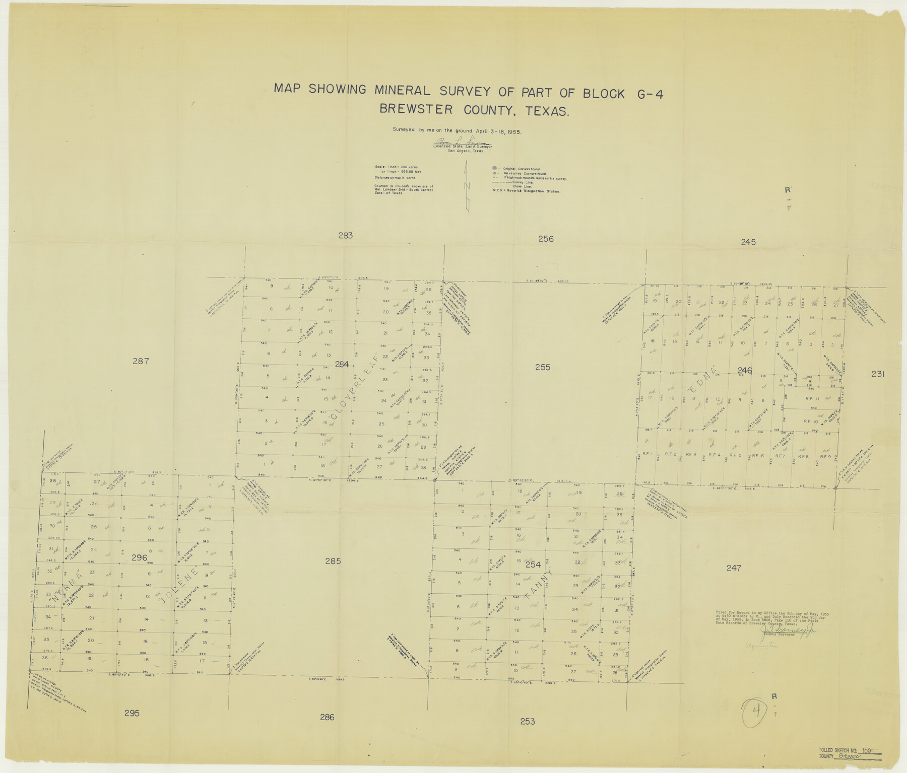
Brewster County Rolled Sketch 102
Map showing mineral survey of part of Block G-4, Brewster County, Texas
-
Map/Doc
8513
-
Collection
General Map Collection
-
Object Dates
1955/4/18 (Survey Date)
-
People and Organizations
Byron L. Simpson (Surveyor/Engineer)
-
Counties
Brewster
-
Subjects
Surveying Rolled Sketch
-
Height x Width
37.0 x 43.4 inches
94.0 x 110.2 cm
-
Medium
blueprint/diazo
-
Scale
1" = 200 varas
Part of: General Map Collection
Pecos County Rolled Sketch 186

Print $20.00
- Digital $50.00
Pecos County Rolled Sketch 186
1985
Size 39.3 x 27.5 inches
Map/Doc 7305
Galveston County Sketch File 26

Print $4.00
- Digital $50.00
Galveston County Sketch File 26
1860
Size 11.8 x 5.7 inches
Map/Doc 23397
Flight Mission No. BRA-16M, Frame 165, Jefferson County

Print $20.00
- Digital $50.00
Flight Mission No. BRA-16M, Frame 165, Jefferson County
1953
Size 18.6 x 22.4 inches
Map/Doc 85763

DeWitt County Sketch File 4

Print $4.00
- Digital $50.00
DeWitt County Sketch File 4
1872
Size 8.3 x 13.1 inches
Map/Doc 20801
El Paso County Rolled Sketch 46A

Print $20.00
- Digital $50.00
El Paso County Rolled Sketch 46A
1937
Size 35.1 x 30.2 inches
Map/Doc 5833
Navigation Maps of Gulf Intracoastal Waterway, Port Arthur to Brownsville, Texas

Print $4.00
- Digital $50.00
Navigation Maps of Gulf Intracoastal Waterway, Port Arthur to Brownsville, Texas
1951
Size 16.7 x 21.2 inches
Map/Doc 65449
Outer Continental Shelf Leasing Maps (Louisiana Offshore Operations)

Print $20.00
- Digital $50.00
Outer Continental Shelf Leasing Maps (Louisiana Offshore Operations)
1955
Size 20.2 x 15.1 inches
Map/Doc 75858
Flight Mission No. DAG-22K, Frame 76, Matagorda County

Print $20.00
- Digital $50.00
Flight Mission No. DAG-22K, Frame 76, Matagorda County
1953
Size 18.7 x 22.4 inches
Map/Doc 86463
Flight Mission No. DCL-6C, Frame 6, Kenedy County

Print $20.00
- Digital $50.00
Flight Mission No. DCL-6C, Frame 6, Kenedy County
1943
Size 18.6 x 22.3 inches
Map/Doc 85866
Flight Mission No. CRE-2R, Frame 152, Jackson County

Print $20.00
- Digital $50.00
Flight Mission No. CRE-2R, Frame 152, Jackson County
1956
Size 16.3 x 16.1 inches
Map/Doc 85363
Harris County Working Sketch 5

Print $20.00
- Digital $50.00
Harris County Working Sketch 5
Size 35.1 x 28.0 inches
Map/Doc 65897
You may also like
Donley County Boundary File 7

Print $31.00
- Digital $50.00
Donley County Boundary File 7
Size 11.3 x 8.6 inches
Map/Doc 52640
Presidio County Rolled Sketch T-4

Print $20.00
- Digital $50.00
Presidio County Rolled Sketch T-4
1949
Size 32.1 x 15.7 inches
Map/Doc 7418
Montgomery County Working Sketch 45

Print $20.00
- Digital $50.00
Montgomery County Working Sketch 45
1956
Size 14.8 x 29.5 inches
Map/Doc 71152
Upton County Working Sketch 45

Print $20.00
- Digital $50.00
Upton County Working Sketch 45
1968
Size 44.2 x 38.2 inches
Map/Doc 69541
Hamilton County Working Sketch 18

Print $20.00
- Digital $50.00
Hamilton County Working Sketch 18
1952
Size 22.4 x 25.1 inches
Map/Doc 63356
Jeff Davis County Sketch File 23

Print $4.00
- Digital $50.00
Jeff Davis County Sketch File 23
1927
Size 13.3 x 8.8 inches
Map/Doc 27990
Northwest Part Crockett County

Print $40.00
- Digital $50.00
Northwest Part Crockett County
1983
Size 38.1 x 48.8 inches
Map/Doc 73121

Borden County Sketch File 3b

Print $40.00
- Digital $50.00
Borden County Sketch File 3b
1902
Size 9.5 x 21.1 inches
Map/Doc 10933
Roberts County

Print $20.00
- Digital $50.00
Roberts County
1878
Size 20.1 x 18.0 inches
Map/Doc 3991
Jack County Working Sketch 11

Print $20.00
- Digital $50.00
Jack County Working Sketch 11
1959
Size 23.9 x 23.4 inches
Map/Doc 66437
Padre Island National Seashore, Texas - Dependent Resurvey

Print $4.00
- Digital $50.00
Padre Island National Seashore, Texas - Dependent Resurvey
2001
Size 18.4 x 24.1 inches
Map/Doc 60553