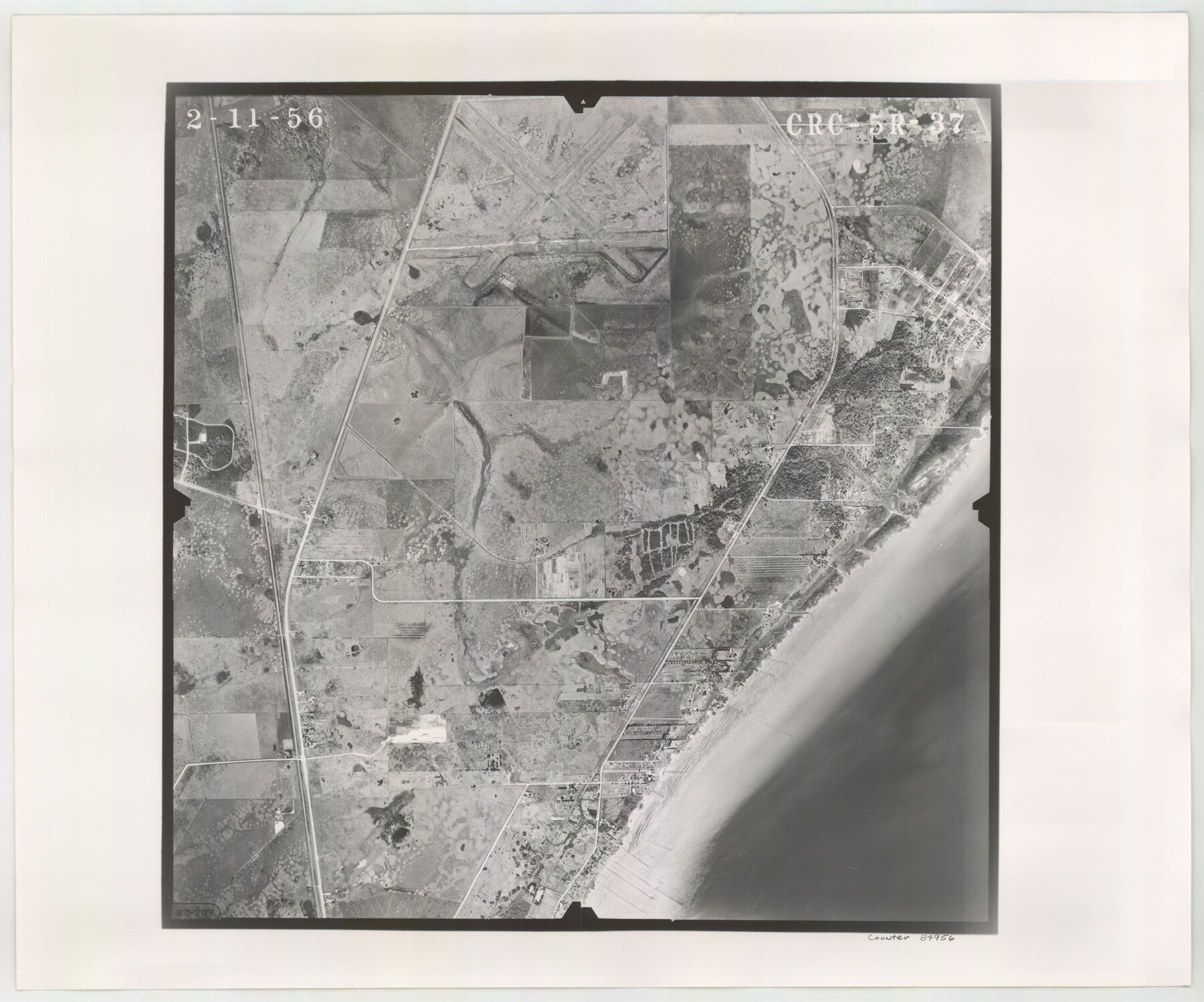
Flight Mission No. CRC-5R, Frame 37, Chambers County
CRC-5R-37
-
Map/Doc
84956
-
Collection
General Map Collection
-
Object Dates
1956/2/11 (Creation Date)
-
People and Organizations
U. S. Department of Agriculture (Publisher)
-
Counties
Chambers
-
Subjects
Aerial Photograph
-
Height x Width
18.6 x 22.4 inches
47.2 x 56.9 cm
-
Comments
Flown by Jack Ammann Photogrammetric Engineers, Inc. of San Antonio, Texas.
Part of: General Map Collection
Right-of-Way and Track Map, Houston and Brazos Valley Ry. Co. operated by the Houston and Brazos Valley Ry. Co.

Print $40.00
- Digital $50.00
Right-of-Way and Track Map, Houston and Brazos Valley Ry. Co. operated by the Houston and Brazos Valley Ry. Co.
1918
Size 24.9 x 56.5 inches
Map/Doc 64608
Wharton County Working Sketch 22

Print $20.00
- Digital $50.00
Wharton County Working Sketch 22
1919
Size 22.1 x 17.7 inches
Map/Doc 72486
Throckmorton County Sketch File 5a

Print $22.00
- Digital $50.00
Throckmorton County Sketch File 5a
Size 8.0 x 7.8 inches
Map/Doc 38075
Map of the City of Galveston, Texas

Print $40.00
- Digital $50.00
Map of the City of Galveston, Texas
1883
Size 37.2 x 66.3 inches
Map/Doc 96981
Trinity River, Clapps Ferry Sheet

Print $20.00
- Digital $50.00
Trinity River, Clapps Ferry Sheet
1925
Size 47.5 x 36.4 inches
Map/Doc 65180
Kerr County Boundary File 6

Print $8.00
- Digital $50.00
Kerr County Boundary File 6
Size 14.2 x 8.7 inches
Map/Doc 64822
Map of Burleson County

Print $20.00
- Digital $50.00
Map of Burleson County
1856
Size 22.0 x 31.5 inches
Map/Doc 3345
Montgomery County Working Sketch 38

Print $20.00
- Digital $50.00
Montgomery County Working Sketch 38
1954
Size 23.6 x 28.5 inches
Map/Doc 71145
Parker County Boundary File 3a

Print $34.00
- Digital $50.00
Parker County Boundary File 3a
Size 11.2 x 8.8 inches
Map/Doc 57840
Runnels County Rolled Sketch 47

Print $40.00
- Digital $50.00
Runnels County Rolled Sketch 47
1954
Size 49.9 x 30.5 inches
Map/Doc 76167
Schleicher County Sketch File 15

Print $22.00
- Digital $50.00
Schleicher County Sketch File 15
1928
Size 8.1 x 12.9 inches
Map/Doc 36504
Burnet County Working Sketch 1

Print $20.00
- Digital $50.00
Burnet County Working Sketch 1
1916
Size 22.4 x 31.9 inches
Map/Doc 67844
You may also like
Oil Development and Structural Map showing Schott, Mirando and other oil fields of the Laredo District with present and proposed development.

Print $20.00
- Digital $50.00
Oil Development and Structural Map showing Schott, Mirando and other oil fields of the Laredo District with present and proposed development.
1920
Size 11.3 x 8.9 inches
Map/Doc 94107
Flight Mission No. CUG-1P, Frame 105, Kleberg County

Print $20.00
- Digital $50.00
Flight Mission No. CUG-1P, Frame 105, Kleberg County
1956
Size 18.5 x 22.3 inches
Map/Doc 86155
Loving County Rolled Sketch 16

Print $20.00
- Digital $50.00
Loving County Rolled Sketch 16
2016
Size 36.3 x 24.6 inches
Map/Doc 94114
Uvalde County Sketch File A

Print $40.00
- Digital $50.00
Uvalde County Sketch File A
1912
Size 23.0 x 18.0 inches
Map/Doc 12537
[T. & P. Block 36, Townships 1N - 5N]
![93132, [T. & P. Block 36, Townships 1N - 5N], Twichell Survey Records](https://historictexasmaps.com/wmedia_w700/maps/93132-1.tif.jpg)
Print $40.00
- Digital $50.00
[T. & P. Block 36, Townships 1N - 5N]
Size 21.3 x 87.8 inches
Map/Doc 93132
G & H Blocks, Gaines County, Texas Resurvey

Print $40.00
- Digital $50.00
G & H Blocks, Gaines County, Texas Resurvey
1915
Size 58.1 x 33.7 inches
Map/Doc 89667
Stephens County Working Sketch 12

Print $20.00
- Digital $50.00
Stephens County Working Sketch 12
1947
Size 20.9 x 22.2 inches
Map/Doc 63955
Hardin County Working Sketch 24

Print $20.00
- Digital $50.00
Hardin County Working Sketch 24
1950
Size 15.3 x 11.9 inches
Map/Doc 63422
Rusk County Sketch File 20

Print $4.00
Rusk County Sketch File 20
1859
Size 10.2 x 8.1 inches
Map/Doc 35530
El Paso County Sketch File 31

Print $185.00
- Digital $50.00
El Paso County Sketch File 31
1968
Size 8.9 x 17.7 inches
Map/Doc 22084
Mitchell County Sketch File 3

Print $4.00
- Digital $50.00
Mitchell County Sketch File 3
1902
Size 9.2 x 8.4 inches
Map/Doc 31690
Upton County Working Sketch 6

Print $20.00
- Digital $50.00
Upton County Working Sketch 6
1909
Size 17.1 x 27.0 inches
Map/Doc 69502