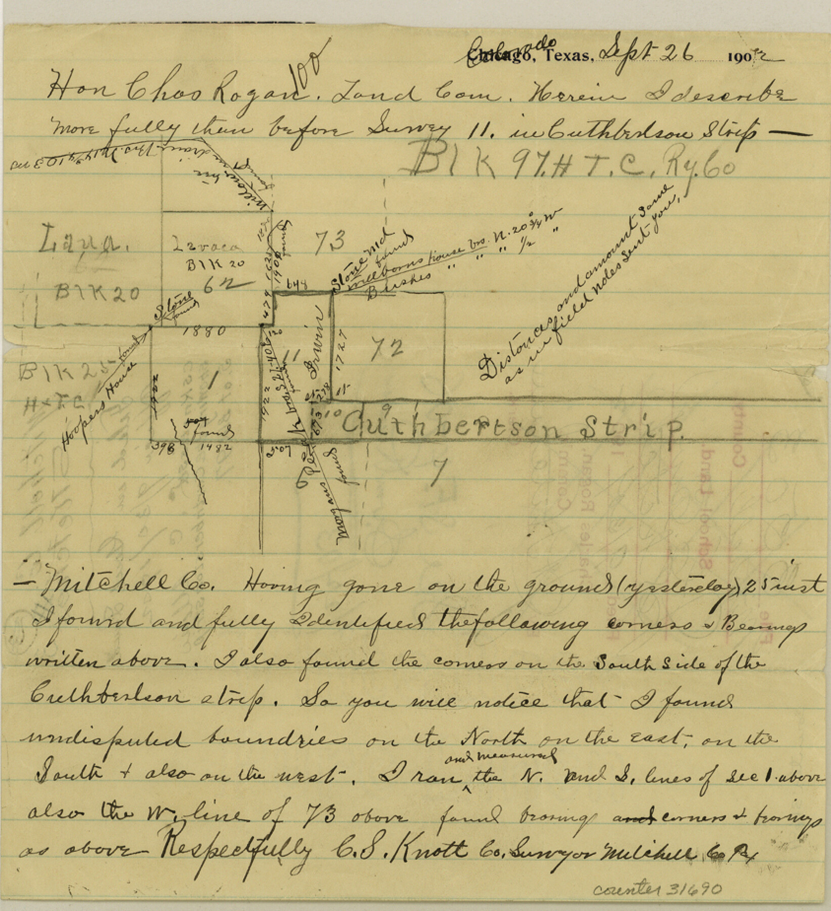
Mitchell County Sketch File 3
[Sketch showing the Cuthbertson Strip]
-
Map/Doc
31690
-
Collection
General Map Collection
-
Object Dates
9/26/1902 (Creation Date)
9/30/1902 (File Date)
-
People and Organizations
C.S. Knott (Surveyor/Engineer)
Charles Rogan (GLO Commissioner)
-
Counties
Mitchell
-
Subjects
Surveying Sketch File
-
Height x Width
9.2 x 8.4 inches
23.4 x 21.3 cm
-
Medium
paper, manuscript
-
Features
Hooper's House
Morgan's Peak
Part of: General Map Collection
Flight Mission No. DIX-8P, Frame 57, Aransas County

Print $20.00
- Digital $50.00
Flight Mission No. DIX-8P, Frame 57, Aransas County
1956
Size 18.7 x 22.4 inches
Map/Doc 83888
Runnels County Working Sketch 28

Print $20.00
- Digital $50.00
Runnels County Working Sketch 28
1959
Size 41.9 x 35.2 inches
Map/Doc 63624

Kaufman County Boundary File 5a

Print $28.00
- Digital $50.00
Kaufman County Boundary File 5a
Size 14.2 x 8.8 inches
Map/Doc 55951
Orange County Rolled Sketch 18

Print $20.00
- Digital $50.00
Orange County Rolled Sketch 18
Size 11.6 x 12.6 inches
Map/Doc 7182
Dawson County Sketch File 20

Print $20.00
- Digital $50.00
Dawson County Sketch File 20
1951
Size 13.2 x 21.5 inches
Map/Doc 11296
Anderson County Boundary File 4

Print $10.00
- Digital $50.00
Anderson County Boundary File 4
Size 8.9 x 7.4 inches
Map/Doc 49737
Brooks County Sketch File 2

Print $40.00
- Digital $50.00
Brooks County Sketch File 2
Size 27.3 x 23.6 inches
Map/Doc 11015
Crane County Working Sketch 25

Print $20.00
- Digital $50.00
Crane County Working Sketch 25
1969
Size 33.0 x 26.3 inches
Map/Doc 68302
Flight Mission No. BRA-8M, Frame 141, Jefferson County

Print $20.00
- Digital $50.00
Flight Mission No. BRA-8M, Frame 141, Jefferson County
1953
Size 18.8 x 22.4 inches
Map/Doc 85633
Flight Mission No. BQR-7K, Frame 27, Brazoria County

Print $20.00
- Digital $50.00
Flight Mission No. BQR-7K, Frame 27, Brazoria County
1952
Size 18.6 x 22.3 inches
Map/Doc 84025
Flight Mission No. DAH-9M, Frame 200, Orange County

Print $20.00
- Digital $50.00
Flight Mission No. DAH-9M, Frame 200, Orange County
1953
Size 18.6 x 22.4 inches
Map/Doc 86868
You may also like
Calhoun County Sketch File 2

Print $40.00
- Digital $50.00
Calhoun County Sketch File 2
1856
Size 20.2 x 15.8 inches
Map/Doc 11032
Flight Mission No. DCL-4C, Frame 120, Kenedy County

Print $20.00
- Digital $50.00
Flight Mission No. DCL-4C, Frame 120, Kenedy County
1943
Size 18.6 x 22.5 inches
Map/Doc 85819
Val Verde County Rolled Sketch 78

Print $20.00
- Digital $50.00
Val Verde County Rolled Sketch 78
1981
Size 42.9 x 29.6 inches
Map/Doc 8140
Sketch Showing Original Corners and Connections affecting Blocks T1, T2, and T3 in Lamb and Castro Counties, Texas

Print $20.00
- Digital $50.00
Sketch Showing Original Corners and Connections affecting Blocks T1, T2, and T3 in Lamb and Castro Counties, Texas
Size 17.3 x 29.1 inches
Map/Doc 92982
Sketch Portion of Lamb County, Texas

Print $20.00
- Digital $50.00
Sketch Portion of Lamb County, Texas
1924
Size 19.9 x 21.4 inches
Map/Doc 92176
Medina County Working Sketch 9

Print $20.00
- Digital $50.00
Medina County Working Sketch 9
1959
Size 25.3 x 38.8 inches
Map/Doc 70924
Map of certain tidal areas in Harris and Galveston Counties showing subdivision thereof for mineral development

Print $20.00
- Digital $50.00
Map of certain tidal areas in Harris and Galveston Counties showing subdivision thereof for mineral development
1938
Size 34.3 x 26.7 inches
Map/Doc 2936
Presidio County Rolled Sketch 22A

Print $20.00
- Digital $50.00
Presidio County Rolled Sketch 22A
1909
Size 20.6 x 31.9 inches
Map/Doc 7332
Flight Mission No. DCL-4C, Frame 68, Kenedy County

Print $20.00
- Digital $50.00
Flight Mission No. DCL-4C, Frame 68, Kenedy County
1943
Size 18.7 x 22.3 inches
Map/Doc 85813
[Right of Way & Track Map, The Texas & Pacific Ry. Co. Main Line]
![64660, [Right of Way & Track Map, The Texas & Pacific Ry. Co. Main Line], General Map Collection](https://historictexasmaps.com/wmedia_w700/maps/64660.tif.jpg)
Print $20.00
- Digital $50.00
[Right of Way & Track Map, The Texas & Pacific Ry. Co. Main Line]
Size 11.0 x 18.6 inches
Map/Doc 64660
Wichita County Sketch File 16

Print $4.00
- Digital $50.00
Wichita County Sketch File 16
1890
Size 12.9 x 8.9 inches
Map/Doc 40095
