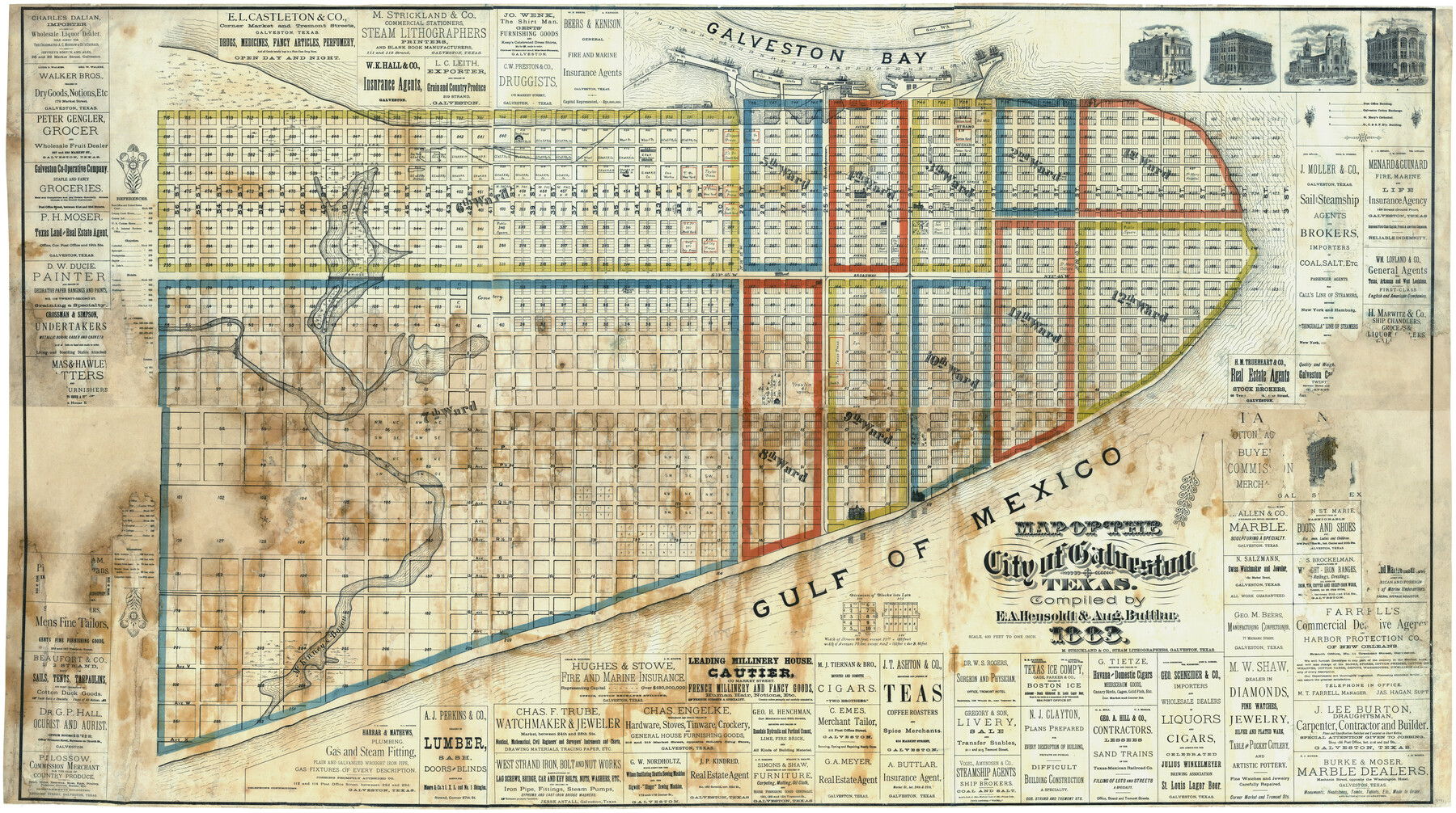
Map of the City of Galveston, Texas
-
Map/Doc
96981
-
Collection
General Map Collection
-
Object Dates
1883 (Creation Date)
-
People and Organizations
M. Strickland & Co. Steam Lithographers (Printer)
E.A. Hensoldt (Compiler)
Aug. Buttlar (Compiler)
-
Counties
Galveston
-
Subjects
City
-
Height x Width
37.2 x 66.3 inches
94.5 x 168.4 cm
-
Medium
paper, etching/engraving/lithograph
-
Scale
1" = 400 feet
Related maps
Galveston Island

Print $20.00
- Digital $50.00
Galveston Island
1837
Size 23.5 x 40.0 inches
Map/Doc 1954
Galveston Island

Print $20.00
- Digital $50.00
Galveston Island
1837
Size 24.1 x 37.2 inches
Map/Doc 2009
Map of the City of Galveston Situated on the East end of Galveston Island

Print $20.00
- Digital $50.00
Map of the City of Galveston Situated on the East end of Galveston Island
1838
Size 22.0 x 38.1 inches
Map/Doc 2170
Part of: General Map Collection
Brazoria County Sketch File 11

Print $4.00
- Digital $50.00
Brazoria County Sketch File 11
Size 10.5 x 8.5 inches
Map/Doc 14965
Crane County Working Sketch 22

Print $20.00
- Digital $50.00
Crane County Working Sketch 22
1961
Size 44.7 x 43.9 inches
Map/Doc 68299
A Map of Lewis and Clark's Track, across the Western Portion of North America from the Mississippi to the Pacific Ocean; by order of the Executive of the United States in 1804, 5 & 6

Print $20.00
- Digital $50.00
A Map of Lewis and Clark's Track, across the Western Portion of North America from the Mississippi to the Pacific Ocean; by order of the Executive of the United States in 1804, 5 & 6
1962
Size 11.5 x 25.1 inches
Map/Doc 97174
Travis County Sketch File 32

Print $20.00
- Digital $50.00
Travis County Sketch File 32
Size 25.3 x 32.7 inches
Map/Doc 12460
Bowie County Sketch File 7c

Print $7.00
- Digital $50.00
Bowie County Sketch File 7c
Size 11.9 x 7.4 inches
Map/Doc 14864
Greer County Sketch File 10

Print $4.00
- Digital $50.00
Greer County Sketch File 10
1929
Size 8.6 x 13.4 inches
Map/Doc 24530
Hardeman County Working Sketch 7

Print $20.00
- Digital $50.00
Hardeman County Working Sketch 7
1952
Size 34.2 x 30.9 inches
Map/Doc 63388
Aransas County Rolled Sketch 5

Print $53.00
- Digital $50.00
Aransas County Rolled Sketch 5
1953
Size 10.5 x 15.4 inches
Map/Doc 42075
Harris County Rolled Sketch GC

Print $40.00
- Digital $50.00
Harris County Rolled Sketch GC
1917
Size 42.1 x 52.4 inches
Map/Doc 9115
Hockley County Sketch File 12

Print $20.00
- Digital $50.00
Hockley County Sketch File 12
1902
Size 17.5 x 17.0 inches
Map/Doc 11772
Flight Mission No. CGI-3N, Frame 140, Cameron County

Print $20.00
- Digital $50.00
Flight Mission No. CGI-3N, Frame 140, Cameron County
1954
Size 18.8 x 22.5 inches
Map/Doc 84613
Maps of Gulf Intracoastal Waterway, Texas - Sabine River to the Rio Grande and connecting waterways including ship channels

Print $20.00
- Digital $50.00
Maps of Gulf Intracoastal Waterway, Texas - Sabine River to the Rio Grande and connecting waterways including ship channels
1966
Size 14.5 x 22.2 inches
Map/Doc 61915
You may also like
Mitchell County

Print $20.00
- Digital $50.00
Mitchell County
1971
Size 43.6 x 37.0 inches
Map/Doc 95592
Flight Mission No. DAG-24K, Frame 148, Matagorda County

Print $20.00
- Digital $50.00
Flight Mission No. DAG-24K, Frame 148, Matagorda County
1953
Size 18.5 x 22.2 inches
Map/Doc 86562
Brazoria County Working Sketch 8

Print $20.00
- Digital $50.00
Brazoria County Working Sketch 8
1932
Size 25.9 x 21.5 inches
Map/Doc 67493
General Highway Map. Detail of Cities and Towns in Harris County, Texas

Print $20.00
General Highway Map. Detail of Cities and Towns in Harris County, Texas
1939
Size 18.3 x 24.7 inches
Map/Doc 79120
Jack County Sketch File 26

Print $4.00
- Digital $50.00
Jack County Sketch File 26
1891
Size 8.7 x 9.3 inches
Map/Doc 27563
Webb County Rolled Sketch 61

Print $20.00
- Digital $50.00
Webb County Rolled Sketch 61
1947
Size 38.6 x 36.5 inches
Map/Doc 10128
Montgomery County Working Sketch 10

Print $20.00
- Digital $50.00
Montgomery County Working Sketch 10
1933
Size 36.5 x 38.6 inches
Map/Doc 71117
Brewster County Sketch File 53

Print $94.00
- Digital $50.00
Brewster County Sketch File 53
1910
Size 13.3 x 8.9 inches
Map/Doc 16361
Webb County Boundary File 4

Print $8.00
- Digital $50.00
Webb County Boundary File 4
Size 11.2 x 8.8 inches
Map/Doc 59761
Taylor County Sketch File 11

Print $20.00
- Digital $50.00
Taylor County Sketch File 11
Size 34.8 x 28.3 inches
Map/Doc 10384
Pecos County Rolled Sketch 158

Print $20.00
- Digital $50.00
Pecos County Rolled Sketch 158
1961
Size 21.9 x 27.4 inches
Map/Doc 7284
Stephens County Sketch File 2

Print $4.00
- Digital $50.00
Stephens County Sketch File 2
1870
Size 12.9 x 8.2 inches
Map/Doc 37013