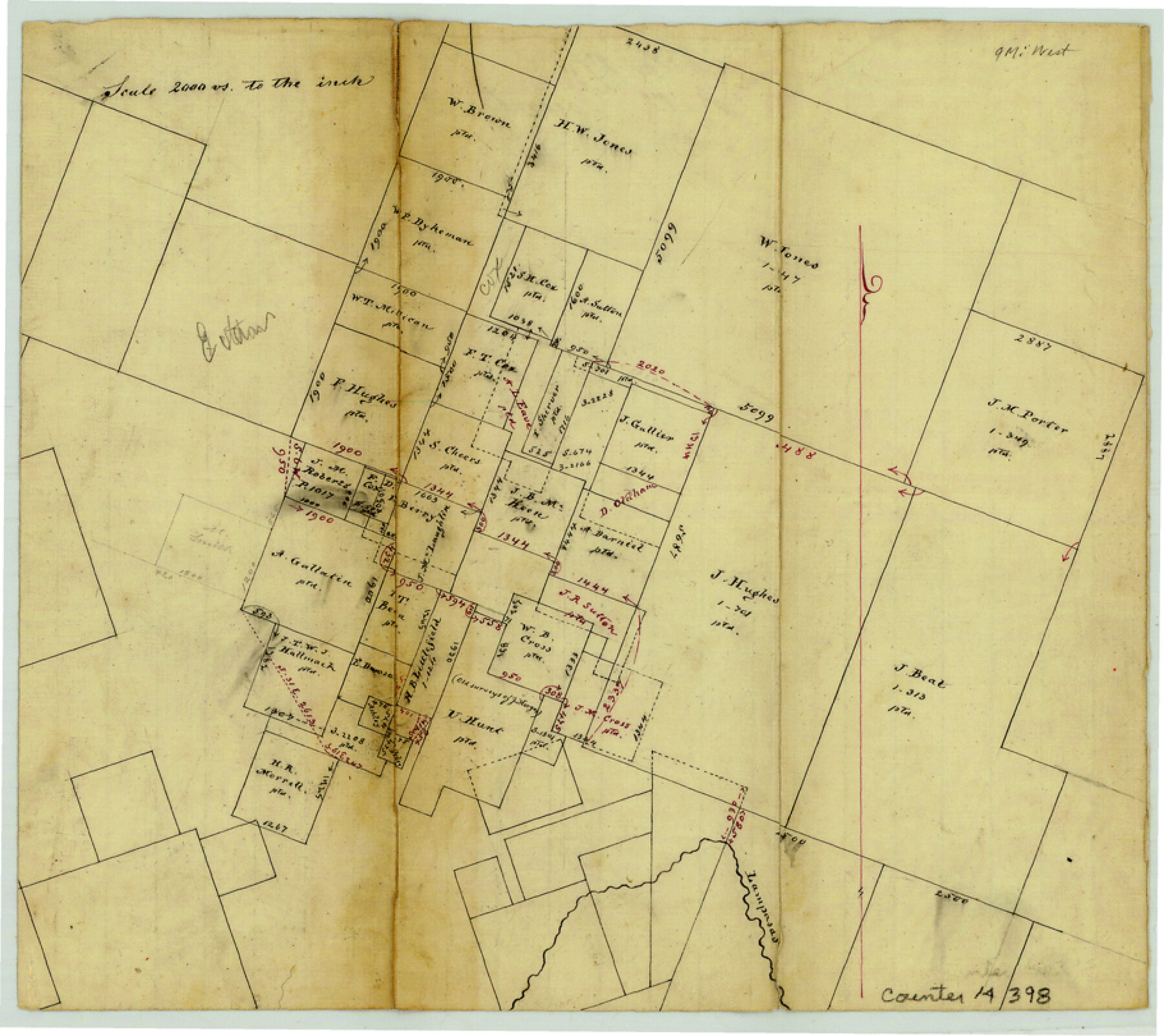
Bell County Sketch File 17
[Sketch of surveys west of Belton near South Nolan Creek]
-
Map/Doc
14398
-
Collection
General Map Collection
-
Counties
Bell
-
Subjects
Surveying Sketch File
-
Height x Width
8.1 x 9.1 inches
20.6 x 23.1 cm
-
Medium
paper, manuscript
-
Scale
1" = 2000 varas
-
Features
Lampasas River
[Noland Creek]
Part of: General Map Collection
Hemphill County Boundary File 1

Print $18.00
- Digital $50.00
Hemphill County Boundary File 1
Size 9.0 x 3.9 inches
Map/Doc 54612
Greer County Sketch File 5

Print $8.00
- Digital $50.00
Greer County Sketch File 5
1883
Size 10.0 x 15.6 inches
Map/Doc 24521
Starr County Sketch File 9

Print $22.00
- Digital $50.00
Starr County Sketch File 9
Size 9.1 x 7.9 inches
Map/Doc 36861


Northwest Part Pecos County

Print $20.00
- Digital $50.00
Northwest Part Pecos County
1975
Size 43.4 x 44.2 inches
Map/Doc 95612
Erath County Working Sketch 40

Print $20.00
- Digital $50.00
Erath County Working Sketch 40
1977
Size 26.2 x 14.9 inches
Map/Doc 69121
Hamilton County Rolled Sketch 13

Print $20.00
- Digital $50.00
Hamilton County Rolled Sketch 13
1982
Size 34.0 x 28.0 inches
Map/Doc 6062
Borden County Sketch File 8

Print $2.00
- Digital $50.00
Borden County Sketch File 8
1934
Size 11.5 x 7.3 inches
Map/Doc 14727
Johnson County Working Sketch 2

Print $20.00
- Digital $50.00
Johnson County Working Sketch 2
Size 20.8 x 20.2 inches
Map/Doc 66615
Map of Texas Coast from San Luis to Jupiter

Print $40.00
- Digital $50.00
Map of Texas Coast from San Luis to Jupiter
1852
Size 31.3 x 74.7 inches
Map/Doc 69975
Gray's New Map of Texas and the Indian Territory

Print $20.00
- Digital $50.00
Gray's New Map of Texas and the Indian Territory
1876
Size 17.6 x 28.6 inches
Map/Doc 97282
You may also like
Nueces County Sketch File 59

Print $23.00
- Digital $50.00
Nueces County Sketch File 59
1989
Size 11.2 x 8.6 inches
Map/Doc 32951
Navarro County Sketch File 22

Print $6.00
- Digital $50.00
Navarro County Sketch File 22
1873
Size 10.0 x 8.0 inches
Map/Doc 32352
Texas Coordinate File 6

Print $40.00
- Digital $50.00
Texas Coordinate File 6
1946
Size 23.7 x 49.0 inches
Map/Doc 75314
Houston County Working Sketch 9

Print $20.00
- Digital $50.00
Houston County Working Sketch 9
1939
Size 28.9 x 31.3 inches
Map/Doc 66239
Terrell County Working Sketch 16

Print $40.00
- Digital $50.00
Terrell County Working Sketch 16
1927
Size 37.7 x 51.4 inches
Map/Doc 62165
[Beaumont, Sour Lake and Western Ry. Right of Way and Alignment - Frisco]
![64111, [Beaumont, Sour Lake and Western Ry. Right of Way and Alignment - Frisco], General Map Collection](https://historictexasmaps.com/wmedia_w700/maps/64111.tif.jpg)
Print $20.00
- Digital $50.00
[Beaumont, Sour Lake and Western Ry. Right of Way and Alignment - Frisco]
1910
Size 19.8 x 45.9 inches
Map/Doc 64111
Reeves County Rolled Sketch 22

Print $20.00
- Digital $50.00
Reeves County Rolled Sketch 22
1960
Size 40.8 x 20.9 inches
Map/Doc 7490
Young County Working Sketch 18

Print $20.00
- Digital $50.00
Young County Working Sketch 18
1960
Size 23.9 x 29.2 inches
Map/Doc 62041
Stephens County

Print $20.00
- Digital $50.00
Stephens County
1940
Size 42.5 x 40.4 inches
Map/Doc 73293
Fannin County Sketch File 6

Print $20.00
- Digital $50.00
Fannin County Sketch File 6
1857
Size 17.0 x 14.5 inches
Map/Doc 11469
[Part of Block GG]
![90314, [Part of Block GG], Twichell Survey Records](https://historictexasmaps.com/wmedia_w700/maps/90314-1.tif.jpg)
Print $20.00
- Digital $50.00
[Part of Block GG]
Size 15.2 x 21.5 inches
Map/Doc 90314
Right of Way and Track Map Houston & Texas Central R.R. operated by the T. and N. O. R.R. Co., Fort Worth Branch

Print $40.00
- Digital $50.00
Right of Way and Track Map Houston & Texas Central R.R. operated by the T. and N. O. R.R. Co., Fort Worth Branch
1918
Size 30.7 x 56.4 inches
Map/Doc 64542