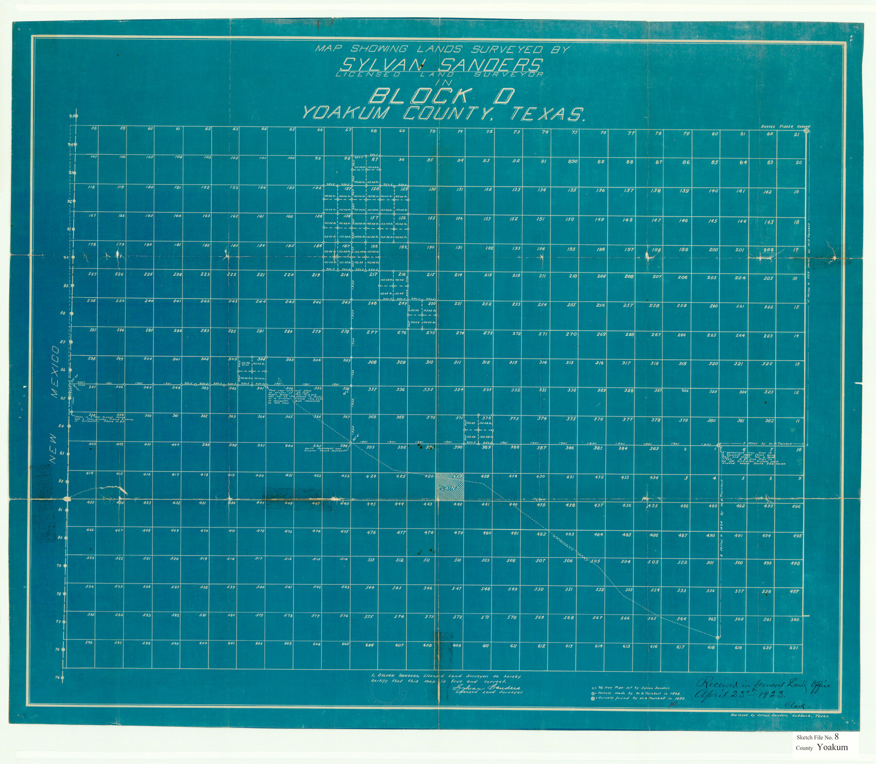
Yoakum County Sketch File 8
Map showing lands surveyed by Sylvan Sanders licensed land surveyor in Block D., Yoakum County, Texas.
-
Map/Doc
12705
-
Collection
General Map Collection
-
Object Dates
1923/4/23 (File Date)
-
People and Organizations
Sylvan Sanders (Surveyor/Engineer)
W.D. Twichell (Surveyor/Engineer)
-
Counties
Yoakum
-
Subjects
Surveying Sketch File
-
Height x Width
25.6 x 29.3 inches
65.0 x 74.4 cm
-
Medium
blueprint/diazo
-
Features
Plains
Part of: General Map Collection
Flight Mission No. DAG-23K, Frame 164, Matagorda County

Print $20.00
- Digital $50.00
Flight Mission No. DAG-23K, Frame 164, Matagorda County
1953
Size 18.6 x 22.3 inches
Map/Doc 86502
Map of Texas compiled from surveys recorded in the Land Office of Texas and other official surveys

Print $20.00
- Digital $50.00
Map of Texas compiled from surveys recorded in the Land Office of Texas and other official surveys
1841
Size 24.6 x 24.2 inches
Map/Doc 96435
Carson County Boundary File 2

Print $56.00
- Digital $50.00
Carson County Boundary File 2
Size 14.0 x 8.6 inches
Map/Doc 51121
Brazos River, Brazos River Sheet 3

Print $6.00
- Digital $50.00
Brazos River, Brazos River Sheet 3
1926
Size 23.6 x 35.2 inches
Map/Doc 65295
Crockett County Rolled Sketch 62

Print $20.00
- Digital $50.00
Crockett County Rolled Sketch 62
1947
Size 27.0 x 38.1 inches
Map/Doc 5605
Controlled Mosaic by Jack Amman Photogrammetric Engineers, Inc - Sheet 49

Print $20.00
- Digital $50.00
Controlled Mosaic by Jack Amman Photogrammetric Engineers, Inc - Sheet 49
1954
Size 20.0 x 24.0 inches
Map/Doc 83508
Frio County Sketch File 13

Print $10.00
- Digital $50.00
Frio County Sketch File 13
1948
Size 11.3 x 8.8 inches
Map/Doc 23136
Aransas Pass to Baffin Bay

Print $20.00
- Digital $50.00
Aransas Pass to Baffin Bay
1961
Size 42.1 x 35.4 inches
Map/Doc 73414
Wise County Rolled Sketch 3

Print $20.00
- Digital $50.00
Wise County Rolled Sketch 3
Size 36.4 x 45.0 inches
Map/Doc 10156
Parker County Sketch File C

Print $4.00
- Digital $50.00
Parker County Sketch File C
1857
Size 6.1 x 7.8 inches
Map/Doc 33512

Dawson County Sketch File 30

Print $40.00
- Digital $50.00
Dawson County Sketch File 30
1913
Size 13.6 x 9.1 inches
Map/Doc 20594
You may also like

Collin County Working Sketch 2

Print $20.00
- Digital $50.00
Collin County Working Sketch 2
1926
Size 15.2 x 17.7 inches
Map/Doc 68096
[Leagues 575, 578, 609, and 616, Blocks T2, T3, and K13]
![91053, [Leagues 575, 578, 609, and 616, Blocks T2, T3, and K13], Twichell Survey Records](https://historictexasmaps.com/wmedia_w700/maps/91053-1.tif.jpg)
Print $20.00
- Digital $50.00
[Leagues 575, 578, 609, and 616, Blocks T2, T3, and K13]
Size 20.5 x 20.0 inches
Map/Doc 91053
Caldwell County Sketch File 3

Print $4.00
- Digital $50.00
Caldwell County Sketch File 3
1872
Size 12.7 x 8.1 inches
Map/Doc 35827
Gregg County Working Sketch 21

Print $20.00
- Digital $50.00
Gregg County Working Sketch 21
1966
Size 25.5 x 32.1 inches
Map/Doc 63288
Reagan County Rolled Sketch 21

Print $20.00
- Digital $50.00
Reagan County Rolled Sketch 21
1950
Size 32.5 x 42.2 inches
Map/Doc 9815
Flight Mission No. DIX-6P, Frame 115, Aransas County

Print $20.00
- Digital $50.00
Flight Mission No. DIX-6P, Frame 115, Aransas County
1956
Size 19.3 x 22.8 inches
Map/Doc 83821
Howard County Rolled Sketch 8

Print $20.00
- Digital $50.00
Howard County Rolled Sketch 8
Size 16.8 x 40.2 inches
Map/Doc 6237
Kent County, 1898

Print $20.00
- Digital $50.00
Kent County, 1898
1898
Size 38.1 x 41.6 inches
Map/Doc 89706
Liberty County Working Sketch 76

Print $20.00
- Digital $50.00
Liberty County Working Sketch 76
1980
Size 13.7 x 18.5 inches
Map/Doc 70536
Eastland County Boundary File 26a

Print $32.00
- Digital $50.00
Eastland County Boundary File 26a
Size 12.7 x 8.1 inches
Map/Doc 52813
Reeves County Rolled Sketch 24

Print $20.00
- Digital $50.00
Reeves County Rolled Sketch 24
1982
Size 37.2 x 24.9 inches
Map/Doc 7493