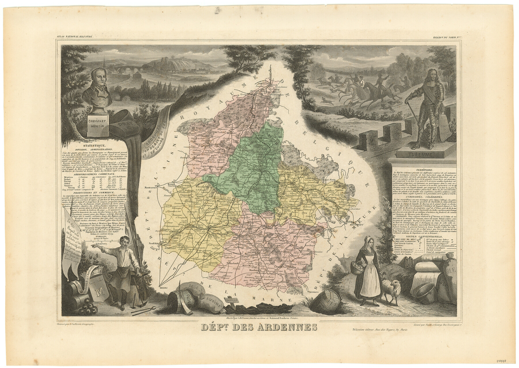
Dépt. des Ardennes
-
Map/Doc
94448
-
Collection
General Map Collection
-
Object Dates
1859 - 1872 (Edition Date)
-
People and Organizations
Pelissier (Publisher)
Smith et George (Printer)
James Harkins (Donor)
Victor Levasseur (Author)
A.M. Perrot (Illustrator)
Raimond Bonheur (Illustrator)
A. Vuillemin (Cartographer)
-
Subjects
Atlas Europe
-
Height x Width
14.5 x 20.5 inches
36.8 x 52.1 cm
-
Medium
paper, etching/engraving/lithograph
-
Comments
From Victor Levasseur's 'Atlas National Illustré'. Published by Pelissier which makes this Atlas dated between 1859 and 1872.
Map donated by James Harkins.
Part of: General Map Collection
Travis County Sketch File 36

Print $4.00
- Digital $50.00
Travis County Sketch File 36
1912
Size 8.4 x 9.9 inches
Map/Doc 38355
Map of Castro's Colony - Bexar District

Print $20.00
- Digital $50.00
Map of Castro's Colony - Bexar District
1851
Size 36.4 x 33.1 inches
Map/Doc 1962
Edwards County Rolled Sketch 26

Print $20.00
- Digital $50.00
Edwards County Rolled Sketch 26
1958
Size 25.0 x 17.5 inches
Map/Doc 5812
Duval County Working Sketch 29

Print $20.00
- Digital $50.00
Duval County Working Sketch 29
1948
Size 28.9 x 31.5 inches
Map/Doc 68753
Houston County Sketch File 29

Print $10.00
- Digital $50.00
Houston County Sketch File 29
1859
Size 15.0 x 9.4 inches
Map/Doc 26802
Live Oak County Working Sketch 28

Print $20.00
- Digital $50.00
Live Oak County Working Sketch 28
1982
Size 33.3 x 21.1 inches
Map/Doc 70613

San Augustine Co.

Print $40.00
- Digital $50.00
San Augustine Co.
1949
Size 48.9 x 32.2 inches
Map/Doc 95632
Midland County

Print $20.00
- Digital $50.00
Midland County
1896
Size 23.0 x 21.1 inches
Map/Doc 3878
Lee County Working Sketch 14

Print $20.00
- Digital $50.00
Lee County Working Sketch 14
1981
Size 17.9 x 11.4 inches
Map/Doc 70393
Jim Hogg County Rolled Sketch 6

Print $40.00
- Digital $50.00
Jim Hogg County Rolled Sketch 6
1943
Size 51.9 x 38.4 inches
Map/Doc 9322
San Patricio County Rolled Sketch 48

Print $20.00
- Digital $50.00
San Patricio County Rolled Sketch 48
1984
Size 42.5 x 26.8 inches
Map/Doc 9903
You may also like
[T. & N. O. RR. Block T5]
![91145, [T. & N. O. RR. Block T5], Twichell Survey Records](https://historictexasmaps.com/wmedia_w700/maps/91145-1.tif.jpg)
Print $20.00
- Digital $50.00
[T. & N. O. RR. Block T5]
Size 32.8 x 28.9 inches
Map/Doc 91145
Callahan County Boundary File 1

Print $120.00
- Digital $50.00
Callahan County Boundary File 1
Size 14.2 x 8.6 inches
Map/Doc 51025
Hall County Sketch File 31

Print $8.00
- Digital $50.00
Hall County Sketch File 31
1951
Size 14.3 x 8.9 inches
Map/Doc 24835
Brewster County Rolled Sketch 114

Print $20.00
- Digital $50.00
Brewster County Rolled Sketch 114
1964
Size 11.4 x 18.4 inches
Map/Doc 5277
Gregg County Sketch File 1A

Print $6.00
- Digital $50.00
Gregg County Sketch File 1A
1847
Size 8.3 x 7.6 inches
Map/Doc 24535
Southern Cattle Fever

Print $20.00
- Digital $50.00
Southern Cattle Fever
1885
Size 9.2 x 13.7 inches
Map/Doc 95143
Hockley County

Print $20.00
- Digital $50.00
Hockley County
1954
Size 44.2 x 39.7 inches
Map/Doc 95531
Cooke County Sketch File 40

Print $20.00
- Digital $50.00
Cooke County Sketch File 40
Size 36.3 x 34.0 inches
Map/Doc 10341
Liberty County Sketch File 64

Print $4.00
- Digital $50.00
Liberty County Sketch File 64
1873
Size 9.9 x 7.9 inches
Map/Doc 30126
Wichita County Sketch File D

Print $22.00
- Digital $50.00
Wichita County Sketch File D
1919
Size 12.0 x 8.6 inches
Map/Doc 40061
Webb County Working Sketch 27

Print $20.00
- Digital $50.00
Webb County Working Sketch 27
1932
Size 24.0 x 19.5 inches
Map/Doc 72392
San Antonio & Aransas Pass R.R. Right of Way from Eagle Lake to Brazos River

Print $20.00
- Digital $50.00
San Antonio & Aransas Pass R.R. Right of Way from Eagle Lake to Brazos River
1895
Size 29.7 x 13.0 inches
Map/Doc 64257