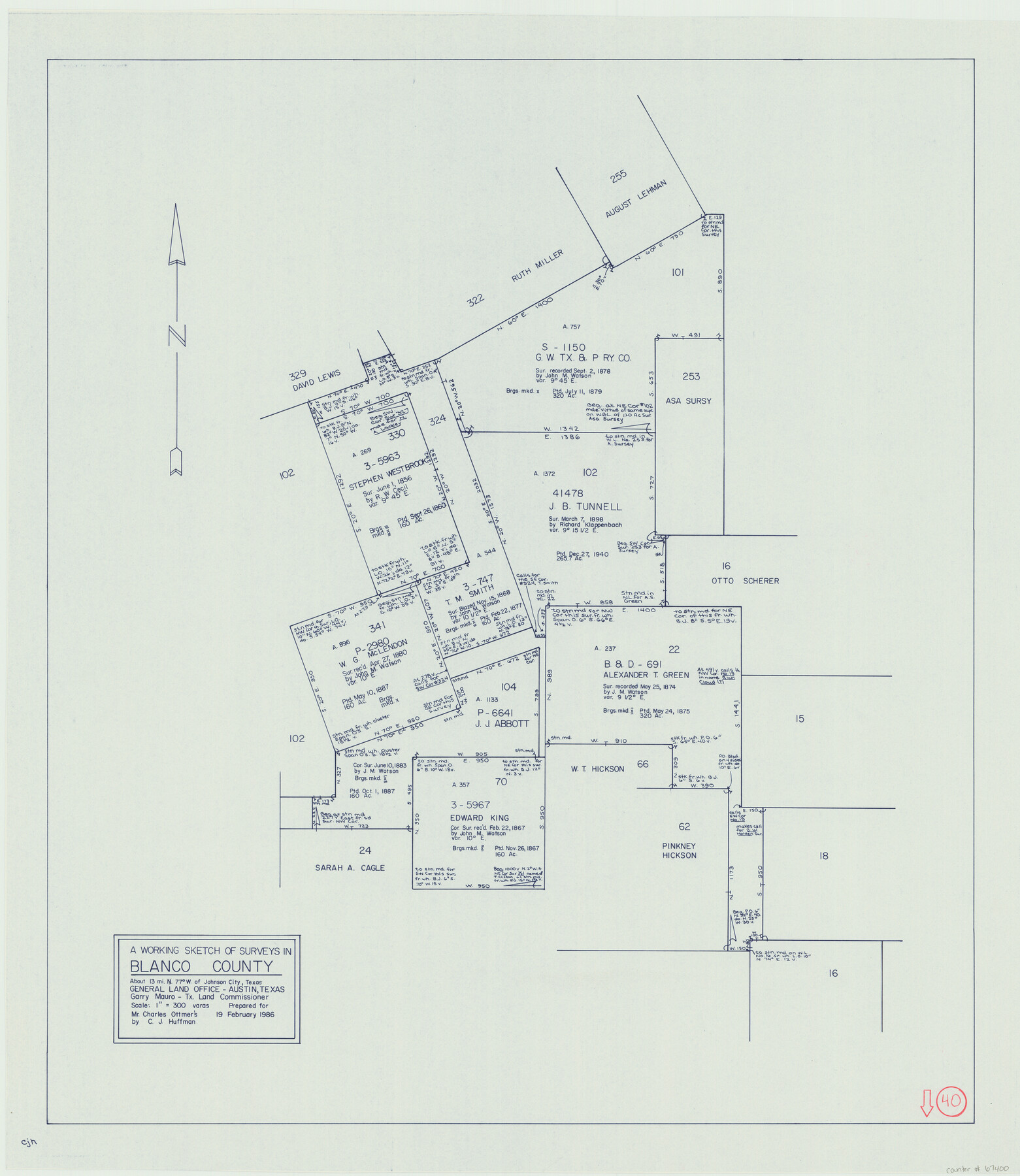
Blanco County Working Sketch 40
- 
                          Map/Doc
67400
 - 
                            Collection
General Map Collection
 - 
                            Object Dates
2/19/1986 (Creation Date)
 - 
                            People and Organizations
Garry Mauro (GLO Commissioner)
Huffman, Cynthia J. (Draftsman)
 - 
                            Counties
Blanco
 - 
                            Subjects
Surveying Working Sketch
 - 
                            Height x Width
28.3 x 24.5 inches
71.9 x 62.2 cm
 - 
                            Scale
1" = 300 varas
 - 
                            Comments
Surveys located about 13 miles North 77 degrees West of Johnson City, Texas.
 
Part of: General Map Collection
            Starr County Sketch File 25


                                            Print $42.00                    
                                             -                         Digital $50.00                                    
                Starr County Sketch File 25
1921
Size 9.1 x 8.6 inches
                                Map/Doc 36927
            
            Baylor County Sketch File 22


                                            Print $10.00                    
                                             -                         Digital $50.00                                    
                Baylor County Sketch File 22
1913
Size 11.2 x 8.8 inches
                                Map/Doc 14199
            
            Lynn County Boundary File 3


                                            Print $6.00                    
                                             -                         Digital $50.00                                    
                Lynn County Boundary File 3
Size 6.3 x 8.8 inches
                                Map/Doc 56623
            
            Duval County Working Sketch 11


                                            Print $20.00                    
                                             -                         Digital $50.00                                    
                Duval County Working Sketch 11
1937
Size 24.3 x 19.4 inches
                                Map/Doc 68724
            
            Maps of Gulf Intracoastal Waterway, Texas - Sabine River to the Rio Grande and connecting waterways including ship channels


                                            Print $20.00                    
                                             -                         Digital $50.00                                    
                Maps of Gulf Intracoastal Waterway, Texas - Sabine River to the Rio Grande and connecting waterways including ship channels
1966
Size 14.5 x 22.3 inches
                                Map/Doc 61942
            
            Cooke County Working Sketch 19


                                            Print $20.00                    
                                             -                         Digital $50.00                                    
                Cooke County Working Sketch 19
1954
Size 23.8 x 20.7 inches
                                Map/Doc 68256
            
            Flight Mission No. DAG-26K, Frame 58, Matagorda County


                                            Print $20.00                    
                                             -                         Digital $50.00                                    
                Flight Mission No. DAG-26K, Frame 58, Matagorda County
1953
Size 18.5 x 16.1 inches
                                Map/Doc 86578
            
            Crockett County Rolled Sketch P1


                                            Print $82.00                    
                                             -                         Digital $50.00                                    
                Crockett County Rolled Sketch P1
1927
Size 10.3 x 15.9 inches
                                Map/Doc 44220
            
            Right of Way & Track Map, St. Louis, Brownsville & Mexico Ry. operated by St. Louis, Brownsville & Mexico Ry. Co.


                                            Print $40.00                    
                                             -                         Digital $50.00                                    
                Right of Way & Track Map, St. Louis, Brownsville & Mexico Ry. operated by St. Louis, Brownsville & Mexico Ry. Co.
1919
Size 25.8 x 56.9 inches
                                Map/Doc 64620
            
            Carte de la Louisiane et du Cours du Mississipi


                                            Print $20.00                    
                                             -                         Digital $50.00                                    
                Carte de la Louisiane et du Cours du Mississipi
Size 21.7 x 28.6 inches
                                Map/Doc 95161
            
            [Surveys in Bastrop County]


                                            Print $2.00                    
                                             -                         Digital $50.00                                    
                [Surveys in Bastrop County]
1841
Size 11.3 x 8.4 inches
                                Map/Doc 3179
            
            Jeff Davis County Sketch File 21


                                            Print $4.00                    
                                             -                         Digital $50.00                                    
                Jeff Davis County Sketch File 21
1927
Size 14.1 x 8.8 inches
                                Map/Doc 27988
            You may also like
            [Blocks 178, 194, Z]


                                            Print $3.00                    
                                             -                         Digital $50.00                                    
                [Blocks 178, 194, Z]
Size 12.8 x 10.5 inches
                                Map/Doc 91579
            
            Port Facilities at Houston, Tex.


                                            Print $20.00                    
                                             -                         Digital $50.00                                    
                Port Facilities at Houston, Tex.
Size 14.1 x 30.3 inches
                                Map/Doc 97167
            
            Childress County


                                            Print $20.00                    
                                             -                         Digital $50.00                                    
                Childress County
1883
Size 20.8 x 19.0 inches
                                Map/Doc 3394
            
            South Part Pecos County


                                            Print $20.00                    
                                             -                         Digital $50.00                                    
                South Part Pecos County
1976
Size 36.8 x 44.2 inches
                                Map/Doc 73262
            
            [Unidentified Railroad through Denton and Dallas County]


                                            Print $40.00                    
                                             -                         Digital $50.00                                    
                [Unidentified Railroad through Denton and Dallas County]
Size 6.8 x 73.3 inches
                                Map/Doc 64775
            
            Jefferson County Rolled Sketch 23


                                            Print $20.00                    
                                             -                         Digital $50.00                                    
                Jefferson County Rolled Sketch 23
1938
Size 45.9 x 33.3 inches
                                Map/Doc 9289
            
            Trinity River, McKinney Sheet/East Fork of Trinity River


                                            Print $20.00                    
                                             -                         Digital $50.00                                    
                Trinity River, McKinney Sheet/East Fork of Trinity River
1931
Size 40.6 x 28.0 inches
                                Map/Doc 65241
            
            San Patricio County Rolled Sketch 45


                                            Print $20.00                    
                                             -                         Digital $50.00                                    
                San Patricio County Rolled Sketch 45
1979
Size 24.0 x 33.5 inches
                                Map/Doc 7729
            
            Ector County Rolled Sketch WA


                                            Print $20.00                    
                                             -                         Digital $50.00                                    
                Ector County Rolled Sketch WA
Size 26.2 x 30.0 inches
                                Map/Doc 5780
            
            General Highway Map, Hemphill County, Texas


                                            Print $20.00                    
                                    
                General Highway Map, Hemphill County, Texas
1961
Size 18.3 x 24.6 inches
                                Map/Doc 79515