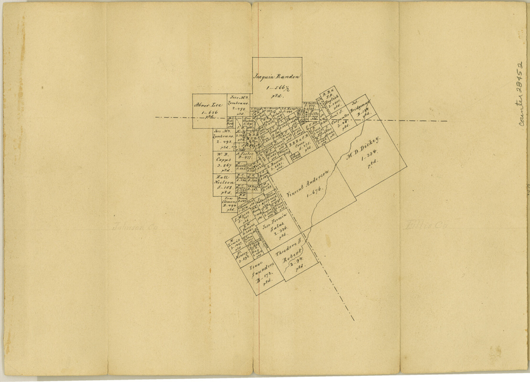
Johnson County Sketch File 14a
[Office sketch in northeast corner of county]
-
Map/Doc
28452
-
Collection
General Map Collection
-
Object Dates
10/1/1862 (Creation Date)
10/1/1862 (File Date)
-
People and Organizations
Pressler (Surveyor/Engineer)
-
Counties
Johnson Tarrant
-
Subjects
Surveying Sketch File
-
Height x Width
8.0 x 11.1 inches
20.3 x 28.2 cm
-
Medium
paper, manuscript
Part of: General Map Collection
Pecos County Working Sketch 86

Print $20.00
- Digital $50.00
Pecos County Working Sketch 86
1962
Size 39.0 x 32.7 inches
Map/Doc 71558
Flight Mission No. DQN-5K, Frame 49, Calhoun County

Print $20.00
- Digital $50.00
Flight Mission No. DQN-5K, Frame 49, Calhoun County
1953
Size 17.4 x 22.3 inches
Map/Doc 84394
[Surveys in Tyler County]
![352, [Surveys in Tyler County], General Map Collection](https://historictexasmaps.com/wmedia_w700/maps/352.tif.jpg)
Print $2.00
- Digital $50.00
[Surveys in Tyler County]
1847
Size 8.3 x 5.2 inches
Map/Doc 352
Val Verde County Working Sketch Graphic Index, Sheet 2 (Sketches 26 to 88)

Print $20.00
- Digital $50.00
Val Verde County Working Sketch Graphic Index, Sheet 2 (Sketches 26 to 88)
1944
Size 40.3 x 36.4 inches
Map/Doc 76725
Sulphur River, Bexelder Sheet/Cuthand Creek

Print $20.00
- Digital $50.00
Sulphur River, Bexelder Sheet/Cuthand Creek
Size 17.3 x 14.1 inches
Map/Doc 78325
Brazoria County Working Sketch 28

Print $20.00
- Digital $50.00
Brazoria County Working Sketch 28
1971
Size 23.8 x 17.2 inches
Map/Doc 67513
[Sketch for Mineral Application 27670 - Strip between Simon Sanchez leagues and Trinity River]
![2866, [Sketch for Mineral Application 27670 - Strip between Simon Sanchez leagues and Trinity River], General Map Collection](https://historictexasmaps.com/wmedia_w700/maps/2866-1.tif.jpg)
Print $20.00
- Digital $50.00
[Sketch for Mineral Application 27670 - Strip between Simon Sanchez leagues and Trinity River]
1934
Size 17.3 x 36.7 inches
Map/Doc 2866
Smith County Sketch File 5

Print $6.00
- Digital $50.00
Smith County Sketch File 5
1857
Size 8.4 x 7.8 inches
Map/Doc 36754
Matagorda County NRC Article 33.136 Location Key Sheet

Print $20.00
- Digital $50.00
Matagorda County NRC Article 33.136 Location Key Sheet
1995
Size 27.0 x 23.0 inches
Map/Doc 87909
Brazoria County Working Sketch 48

Print $20.00
- Digital $50.00
Brazoria County Working Sketch 48
1990
Size 25.2 x 29.5 inches
Map/Doc 67533
Comal County Sketch File 12

Print $4.00
- Digital $50.00
Comal County Sketch File 12
Size 8.4 x 11.3 inches
Map/Doc 19024
Hays County Sketch File 36

Print $4.00
- Digital $50.00
Hays County Sketch File 36
Size 11.0 x 8.5 inches
Map/Doc 96639
You may also like
Map of the County of Calhoun

Print $20.00
- Digital $50.00
Map of the County of Calhoun
1852
Size 21.0 x 20.4 inches
Map/Doc 4431
Texas-Louisiana Gulf Coastal Region showing Oil & Gas Fields & Prospects, Pipe Lines, Refineries & Principal Highways

Print $20.00
- Digital $50.00
Texas-Louisiana Gulf Coastal Region showing Oil & Gas Fields & Prospects, Pipe Lines, Refineries & Principal Highways
1933
Size 22.4 x 44.2 inches
Map/Doc 96874
San Jacinto River, Water Sheds of the San Jacinto River and Buffalo Bayou

Print $4.00
- Digital $50.00
San Jacinto River, Water Sheds of the San Jacinto River and Buffalo Bayou
Size 28.8 x 20.0 inches
Map/Doc 65149
Parker County Rolled Sketch 4

Print $20.00
- Digital $50.00
Parker County Rolled Sketch 4
Size 28.0 x 34.1 inches
Map/Doc 7205
Chambers County Boundary File 1

Print $28.00
- Digital $50.00
Chambers County Boundary File 1
Size 8.9 x 6.7 inches
Map/Doc 51226
Knox County Sketch File 11

Print $20.00
- Digital $50.00
Knox County Sketch File 11
1892
Size 26.8 x 21.9 inches
Map/Doc 11959
Parker County Sketch File 37

Print $4.00
- Digital $50.00
Parker County Sketch File 37
Size 4.8 x 8.1 inches
Map/Doc 33581
Cass County Working Sketch 41

Print $20.00
- Digital $50.00
Cass County Working Sketch 41
1985
Size 34.0 x 42.7 inches
Map/Doc 67944
Houston Ship Channel, Atkinson Island to Alexander Island

Print $40.00
- Digital $50.00
Houston Ship Channel, Atkinson Island to Alexander Island
1992
Size 37.1 x 54.3 inches
Map/Doc 69904
Webb County Working Sketch 68

Print $40.00
- Digital $50.00
Webb County Working Sketch 68
1967
Size 31.6 x 50.7 inches
Map/Doc 72435

Map showing the Kansas & Gulf Short Line R.R. and the Texas & St. Louis R'y with its branches, extensions and connections.

Print $20.00
Map showing the Kansas & Gulf Short Line R.R. and the Texas & St. Louis R'y with its branches, extensions and connections.
1881
Size 30.3 x 30.9 inches
Map/Doc 93608