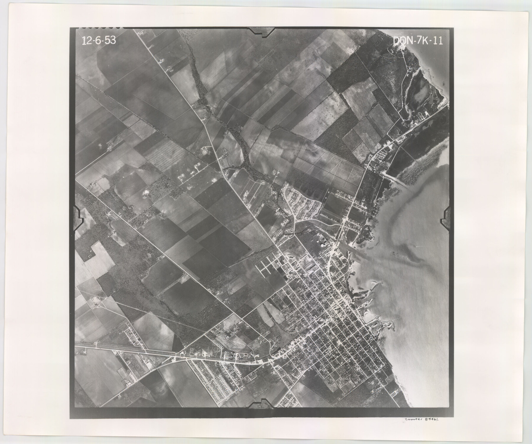
Flight Mission No. DQN-7K, Frame 11, Calhoun County
DQN-7K-11
-
Map/Doc
84462
-
Collection
General Map Collection
-
Object Dates
1953/12/6 (Creation Date)
-
People and Organizations
U. S. Department of Agriculture (Publisher)
-
Counties
Calhoun
-
Subjects
Aerial Photograph
-
Height x Width
18.6 x 22.3 inches
47.2 x 56.6 cm
-
Comments
Flown by Aero Exploration Company of Tulsa, Oklahoma.
Part of: General Map Collection
Hudspeth County Rolled Sketch 66

Print $20.00
- Digital $50.00
Hudspeth County Rolled Sketch 66
1973
Size 11.7 x 18.2 inches
Map/Doc 6263
Matagorda County Rolled Sketch 38

Print $295.00
- Digital $50.00
Matagorda County Rolled Sketch 38
1984
Size 23.2 x 23.2 inches
Map/Doc 6697
San Augustine County Texas

Print $20.00
- Digital $50.00
San Augustine County Texas
1879
Size 23.8 x 16.9 inches
Map/Doc 4623
Ward County Working Sketch 12

Print $20.00
- Digital $50.00
Ward County Working Sketch 12
1947
Size 23.4 x 22.7 inches
Map/Doc 72318
Brewster County Sketch File S-17

Print $30.00
- Digital $50.00
Brewster County Sketch File S-17
1939
Size 11.3 x 8.8 inches
Map/Doc 15799
Flight Mission No. DQO-1K, Frame 94, Galveston County

Print $20.00
- Digital $50.00
Flight Mission No. DQO-1K, Frame 94, Galveston County
1952
Size 18.9 x 22.6 inches
Map/Doc 84990
Flight Mission No. CRE-1R, Frame 121, Jackson County

Print $20.00
- Digital $50.00
Flight Mission No. CRE-1R, Frame 121, Jackson County
1956
Size 16.2 x 16.0 inches
Map/Doc 85332
Real County Sketch File 7

Print $8.00
- Digital $50.00
Real County Sketch File 7
1931
Size 11.3 x 8.8 inches
Map/Doc 35055
Brewster County Working Sketch 18

Print $20.00
- Digital $50.00
Brewster County Working Sketch 18
1934
Size 35.9 x 37.8 inches
Map/Doc 67552
Presidio County Working Sketch Graphic Index, South Part, Sheet 2 (Sketches 45 to Most Recent)

Print $20.00
- Digital $50.00
Presidio County Working Sketch Graphic Index, South Part, Sheet 2 (Sketches 45 to Most Recent)
1975
Size 32.4 x 37.9 inches
Map/Doc 76671
Map of Texas and Pacific Ry. Company's Surveys in the 80 Mile Reserve

Print $40.00
- Digital $50.00
Map of Texas and Pacific Ry. Company's Surveys in the 80 Mile Reserve
1885
Size 41.5 x 91.8 inches
Map/Doc 2300
Right of Way and Track Map, Dayton-Goose Creek Ry. Co., Station 401+20 to Station 612+40

Print $40.00
- Digital $50.00
Right of Way and Track Map, Dayton-Goose Creek Ry. Co., Station 401+20 to Station 612+40
1917
Size 25.4 x 56.4 inches
Map/Doc 64367
You may also like
Brazoria County Sketch File 32

Print $60.00
- Digital $50.00
Brazoria County Sketch File 32
1896
Size 14.1 x 16.2 inches
Map/Doc 10955
[SW Corner of Yoakum County]
![92443, [SW Corner of Yoakum County], Twichell Survey Records](https://historictexasmaps.com/wmedia_w700/maps/92443-1.tif.jpg)
Print $20.00
- Digital $50.00
[SW Corner of Yoakum County]
Size 24.2 x 18.5 inches
Map/Doc 92443
Flight Mission No. BQY-4M, Frame 70, Harris County

Print $20.00
- Digital $50.00
Flight Mission No. BQY-4M, Frame 70, Harris County
1953
Size 18.7 x 22.4 inches
Map/Doc 85279
Jefferson County Working Sketch 11

Print $20.00
- Digital $50.00
Jefferson County Working Sketch 11
1943
Size 46.6 x 43.0 inches
Map/Doc 66554
Map of Leon County

Print $40.00
- Digital $50.00
Map of Leon County
Size 49.7 x 42.0 inches
Map/Doc 66900
Sutton County Sketch File Ca

Print $6.00
- Digital $50.00
Sutton County Sketch File Ca
1901
Size 12.3 x 9.8 inches
Map/Doc 37382
Flight Mission No. BRA-8M, Frame 26, Jefferson County

Print $20.00
- Digital $50.00
Flight Mission No. BRA-8M, Frame 26, Jefferson County
1953
Size 18.6 x 22.3 inches
Map/Doc 85581
Jeff Davis County Sketch File 2a

Print $4.00
- Digital $50.00
Jeff Davis County Sketch File 2a
Size 8.3 x 3.3 inches
Map/Doc 27890
Crockett County Rolled Sketch 24

Print $20.00
- Digital $50.00
Crockett County Rolled Sketch 24
1924
Size 19.5 x 13.0 inches
Map/Doc 5584
Hutchinson County Sketch File 6a

Print $42.00
- Digital $50.00
Hutchinson County Sketch File 6a
1898
Size 7.6 x 8.6 inches
Map/Doc 27202
Bexar County Working Sketch 9

Print $20.00
- Digital $50.00
Bexar County Working Sketch 9
1956
Size 23.4 x 21.6 inches
Map/Doc 67325
Kimble County Boundary File 3a

Print $36.00
- Digital $50.00
Kimble County Boundary File 3a
Size 8.8 x 8.2 inches
Map/Doc 64859