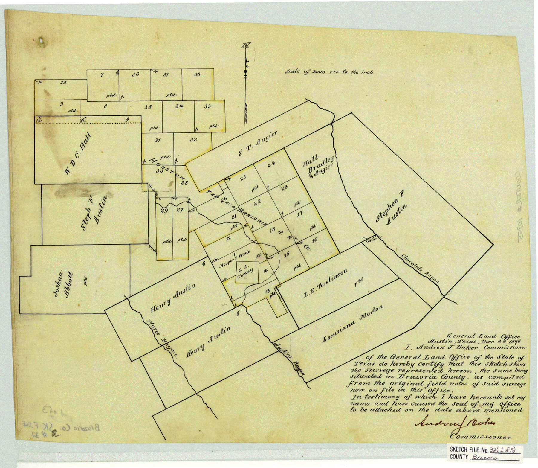
Brazoria County Sketch File 32
[Office sketches of surveys between Chocolate Bayou and Flores Bayou]
-
Map/Doc
10955
-
Collection
General Map Collection
-
Object Dates
1896/12/4 (Creation Date)
-
People and Organizations
Andrew J. Baker (GLO Commissioner)
-
Counties
Brazoria
-
Subjects
Surveying Sketch File
-
Height x Width
14.1 x 16.2 inches
35.8 x 41.1 cm
-
Medium
paper, manuscript
-
Scale
1" = 2000 varas
-
Features
Chocolate Bayou
Flores Bayou
Austin's Bayou
Part of: General Map Collection
Flight Mission No. BRE-3P, Frame 77, Nueces County

Print $20.00
- Digital $50.00
Flight Mission No. BRE-3P, Frame 77, Nueces County
1956
Size 18.6 x 22.6 inches
Map/Doc 86818
Howard County Sketch File 11

Print $40.00
- Digital $50.00
Howard County Sketch File 11
1937
Size 17.6 x 10.2 inches
Map/Doc 26865
Flight Mission No. BQY-15M, Frame 17, Harris County

Print $20.00
- Digital $50.00
Flight Mission No. BQY-15M, Frame 17, Harris County
1953
Size 18.5 x 22.2 inches
Map/Doc 85315
Dallas County Sketch File 12

Print $20.00
- Digital $50.00
Dallas County Sketch File 12
1853
Size 25.4 x 25.2 inches
Map/Doc 11284
Lynn County Rolled Sketch A1

Print $20.00
- Digital $50.00
Lynn County Rolled Sketch A1
1904
Size 39.2 x 43.3 inches
Map/Doc 8347
[Texas Panhandle North Boundary Line]

Print $20.00
- Digital $50.00
[Texas Panhandle North Boundary Line]
1898
Size 11.9 x 46.1 inches
Map/Doc 1737
Cooke County Sketch File 27

Print $24.00
- Digital $50.00
Cooke County Sketch File 27
Size 9.8 x 8.5 inches
Map/Doc 19279
Freestone County Working Sketch 22

Print $20.00
- Digital $50.00
Freestone County Working Sketch 22
1981
Size 35.5 x 32.3 inches
Map/Doc 69264
Presidio County Working Sketch 145

Print $20.00
- Digital $50.00
Presidio County Working Sketch 145
1990
Size 29.5 x 42.7 inches
Map/Doc 71823
Coast Chart No. 203 - Coast of Texas from Sabine Pass Westward to High Island

Print $20.00
- Digital $50.00
Coast Chart No. 203 - Coast of Texas from Sabine Pass Westward to High Island
1901
Size 40.4 x 34.3 inches
Map/Doc 69843
Cass County Sketch File 7

Print $4.00
- Digital $50.00
Cass County Sketch File 7
1853
Size 8.0 x 12.6 inches
Map/Doc 17408
Matagorda County Rolled Sketch 23

Print $20.00
- Digital $50.00
Matagorda County Rolled Sketch 23
1942
Size 25.0 x 23.8 inches
Map/Doc 6690
You may also like
Travis County Rolled Sketch 58

Print $20.00
- Digital $50.00
Travis County Rolled Sketch 58
Size 37.4 x 25.5 inches
Map/Doc 8049
Howard County Working Sketch 13

Print $20.00
- Digital $50.00
Howard County Working Sketch 13
1983
Size 33.3 x 37.3 inches
Map/Doc 66281
Pecos County Rolled Sketch DK5

Print $20.00
- Digital $50.00
Pecos County Rolled Sketch DK5
Size 24.3 x 16.8 inches
Map/Doc 7310
![90327, [Block B9], Twichell Survey Records](https://historictexasmaps.com/wmedia_w700/maps/90327-1.tif.jpg)
Smith County Sketch File 10

Print $6.00
Smith County Sketch File 10
1850
Size 6.8 x 5.1 inches
Map/Doc 36765
Uvalde County Working Sketch 6

Print $20.00
- Digital $50.00
Uvalde County Working Sketch 6
1940
Size 37.8 x 38.9 inches
Map/Doc 72076
Cochran County Rolled Sketch 2

Print $20.00
- Digital $50.00
Cochran County Rolled Sketch 2
1940
Size 27.7 x 33.9 inches
Map/Doc 5500
Atascosa County Sketch File 21

Print $40.00
- Digital $50.00
Atascosa County Sketch File 21
Size 20.0 x 19.8 inches
Map/Doc 10859
Burleson County State Real Property Sketch 1

Print $80.00
- Digital $50.00
Burleson County State Real Property Sketch 1
2003
Size 37.0 x 53.6 inches
Map/Doc 81907
Presidio County Sketch File C

Print $40.00
- Digital $50.00
Presidio County Sketch File C
Size 12.9 x 12.2 inches
Map/Doc 34426
Coke County Sketch File 5

Print $8.00
- Digital $50.00
Coke County Sketch File 5
1886
Size 12.4 x 8.2 inches
Map/Doc 18578
Hall County Sketch File 5

Print $20.00
- Digital $50.00
Hall County Sketch File 5
1884
Size 18.9 x 24.1 inches
Map/Doc 11602