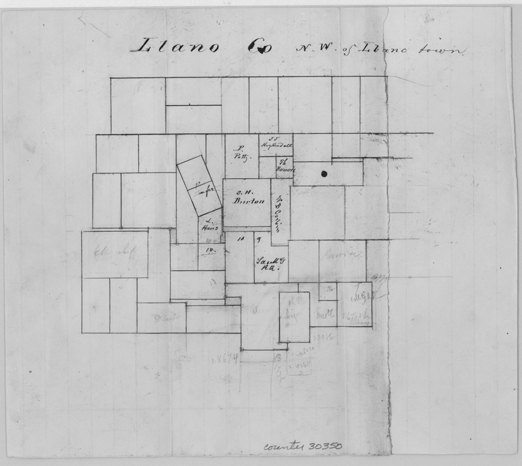
Llano County Sketch File 3
[Letter of explanation and sketch regarding area northwest of Llano near the north boundary line of the county]
-
Map/Doc
30350
-
Collection
General Map Collection
-
Object Dates
10/2/1874 (Creation Date)
10/7/1874 (File Date)
-
People and Organizations
D.C. Cowan (Surveyor/Engineer)
R.F. Rountree (Surveyor/Engineer)
-
Counties
Llano
-
Subjects
Surveying Sketch File
-
Height x Width
8.0 x 8.9 inches
20.3 x 22.6 cm
-
Medium
paper, manuscript
Part of: General Map Collection
Supreme Court of the United States, October Term, 1924, No. 13, Original - The State of Oklahoma, Complainant vs. The State of Texas, Defendant, The United States, Intervener

Print $20.00
- Digital $50.00
Supreme Court of the United States, October Term, 1924, No. 13, Original - The State of Oklahoma, Complainant vs. The State of Texas, Defendant, The United States, Intervener
1924
Size 19.5 x 32.6 inches
Map/Doc 75112
Railroad and County Map of Texas prepared and published as a supplement to the Texas Almanac and State Industrial Guide

Print $20.00
- Digital $50.00
Railroad and County Map of Texas prepared and published as a supplement to the Texas Almanac and State Industrial Guide
Size 22.2 x 23.1 inches
Map/Doc 95353
Milam County Rolled Sketch 3A

Print $40.00
- Digital $50.00
Milam County Rolled Sketch 3A
1967
Size 49.1 x 38.8 inches
Map/Doc 43048
Brooks County Sketch File 6

Print $12.00
- Digital $50.00
Brooks County Sketch File 6
1941
Size 13.2 x 8.3 inches
Map/Doc 16560
Wharton County Sketch File 3

Print $4.00
- Digital $50.00
Wharton County Sketch File 3
1875
Size 9.1 x 8.3 inches
Map/Doc 39915
Kimble County Working Sketch 88

Print $20.00
- Digital $50.00
Kimble County Working Sketch 88
1976
Size 31.5 x 30.8 inches
Map/Doc 70156
Brazoria County Sketch File 21

Print $4.00
- Digital $50.00
Brazoria County Sketch File 21
Size 8.3 x 7.5 inches
Map/Doc 15016
Presidio County Sketch File 105

Print $40.00
- Digital $50.00
Presidio County Sketch File 105
Size 15.6 x 59.1 inches
Map/Doc 82963
Hardeman County Boundary File 3b

Print $12.00
- Digital $50.00
Hardeman County Boundary File 3b
Size 14.1 x 8.7 inches
Map/Doc 54386
Harrison County Boundary File 41 (10)

Print $10.00
- Digital $50.00
Harrison County Boundary File 41 (10)
Size 7.1 x 3.4 inches
Map/Doc 54418
Right of Way and Track Map, Galveston, Harrisburg & San Antonio Ry. operated by the T. & N. O. R.R. Co., Victoria Division, Rosenberg to Beeville

Print $40.00
- Digital $50.00
Right of Way and Track Map, Galveston, Harrisburg & San Antonio Ry. operated by the T. & N. O. R.R. Co., Victoria Division, Rosenberg to Beeville
1918
Size 25.1 x 57.9 inches
Map/Doc 76157
Cottle County Sketch File 14

Print $50.00
- Digital $50.00
Cottle County Sketch File 14
1918
Size 11.3 x 8.8 inches
Map/Doc 19491
You may also like
Harris County Rolled Sketch 88

Print $20.00
- Digital $50.00
Harris County Rolled Sketch 88
1935
Size 34.4 x 22.7 inches
Map/Doc 6122
Castro County Sketch File 4l

Print $4.00
- Digital $50.00
Castro County Sketch File 4l
Size 13.5 x 8.6 inches
Map/Doc 17487
Andrews County Boundary File 1

Print $133.00
- Digital $50.00
Andrews County Boundary File 1
Size 14.6 x 9.0 inches
Map/Doc 49664
[Galveston, Harrisburg & San Antonio Railroad from Cuero to Stockdale]
![64202, [Galveston, Harrisburg & San Antonio Railroad from Cuero to Stockdale], General Map Collection](https://historictexasmaps.com/wmedia_w700/maps/64202.tif.jpg)
Print $20.00
- Digital $50.00
[Galveston, Harrisburg & San Antonio Railroad from Cuero to Stockdale]
1907
Size 13.3 x 33.1 inches
Map/Doc 64202
Kent County Boundary File 8

Print $20.00
- Digital $50.00
Kent County Boundary File 8
Size 14.2 x 8.6 inches
Map/Doc 55873
Fisher County Working Sketch 12

Print $20.00
- Digital $50.00
Fisher County Working Sketch 12
1956
Size 25.2 x 23.2 inches
Map/Doc 69146
Polk County Working Sketch 6

Print $20.00
- Digital $50.00
Polk County Working Sketch 6
1933
Size 22.8 x 32.7 inches
Map/Doc 71621
Burnet County Working Sketch 7

Print $20.00
- Digital $50.00
Burnet County Working Sketch 7
1960
Size 17.9 x 20.3 inches
Map/Doc 67850
Newton County Working Sketch 39

Print $20.00
- Digital $50.00
Newton County Working Sketch 39
1961
Size 36.6 x 41.0 inches
Map/Doc 71285
Flight Mission No. CUG-1P, Frame 76, Kleberg County

Print $20.00
- Digital $50.00
Flight Mission No. CUG-1P, Frame 76, Kleberg County
1956
Size 18.6 x 22.3 inches
Map/Doc 86141
San Jacinto County Working Sketch 44

Print $20.00
- Digital $50.00
San Jacinto County Working Sketch 44
1981
Size 20.6 x 11.4 inches
Map/Doc 63758
Medina County Sketch File 9

Print $6.00
- Digital $50.00
Medina County Sketch File 9
1888
Size 3.9 x 5.7 inches
Map/Doc 31458