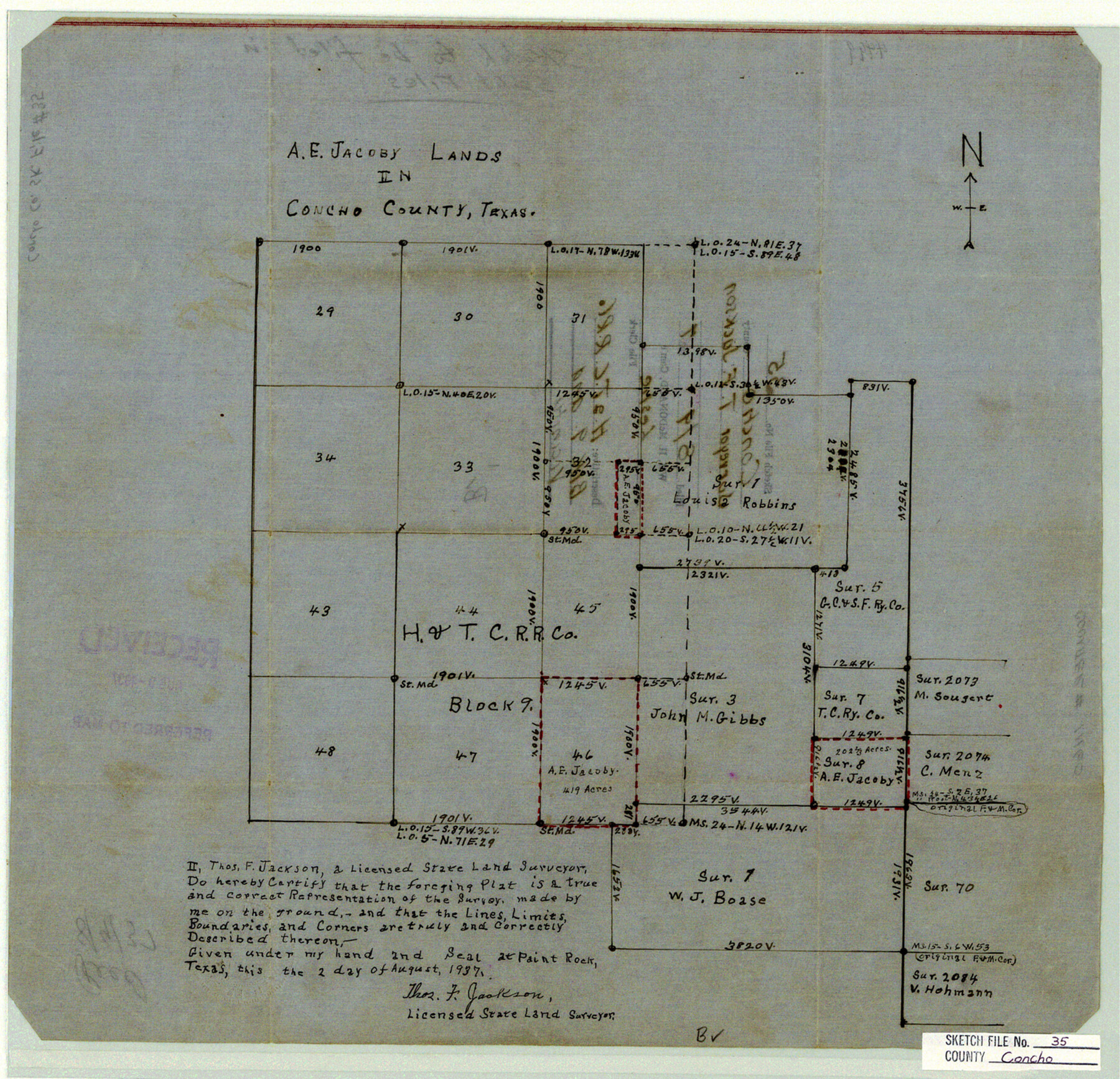
Concho County Sketch File 35
A. E. Jacoby Lands in Concho County, Texas
-
Map/Doc
11160
-
Collection
General Map Collection
-
Object Dates
1937/8/2 (Creation Date)
1937/8/9 (File Date)
-
People and Organizations
Thomas F. Jackson (Surveyor/Engineer)
-
Counties
Concho
-
Subjects
Surveying Sketch File
-
Height x Width
14.9 x 15.5 inches
37.8 x 39.4 cm
-
Medium
paper, manuscript
Part of: General Map Collection
Maverick County Rolled Sketch 18

Print $20.00
- Digital $50.00
Maverick County Rolled Sketch 18
1946
Size 35.6 x 21.5 inches
Map/Doc 6711
Nueces County Sketch File 30

Print $3.00
- Digital $50.00
Nueces County Sketch File 30
1907
Size 11.4 x 11.9 inches
Map/Doc 32600
Coryell County Working Sketch 32

Print $20.00
- Digital $50.00
Coryell County Working Sketch 32
2022
Size 25.3 x 36.9 inches
Map/Doc 96966
Duval County Sketch File 77

Print $20.00
- Digital $50.00
Duval County Sketch File 77
1967
Size 20.4 x 15.5 inches
Map/Doc 11411
Dimmit County Working Sketch 20

Print $20.00
- Digital $50.00
Dimmit County Working Sketch 20
1948
Size 30.4 x 21.3 inches
Map/Doc 68681
Marion County Working Sketch 24

Print $20.00
- Digital $50.00
Marion County Working Sketch 24
1960
Size 21.4 x 26.4 inches
Map/Doc 70800
Pecos County Rolled Sketch 122

Print $20.00
- Digital $50.00
Pecos County Rolled Sketch 122
1945
Size 32.5 x 39.1 inches
Map/Doc 7263

Kaufman County

Print $20.00
- Digital $50.00
Kaufman County
1871
Size 22.3 x 15.0 inches
Map/Doc 3750
Jeff Davis County Rolled Sketch 46

Print $134.00
- Digital $50.00
Jeff Davis County Rolled Sketch 46
2006
Size 17.5 x 24.0 inches
Map/Doc 87213
Comal County Working Sketch 15

Print $20.00
- Digital $50.00
Comal County Working Sketch 15
1994
Size 44.6 x 31.0 inches
Map/Doc 68181
Hutchinson County Rolled Sketch 19

Print $20.00
- Digital $50.00
Hutchinson County Rolled Sketch 19
Size 21.3 x 25.0 inches
Map/Doc 6285
You may also like
Williamson County Sketch File 9

Print $20.00
- Digital $50.00
Williamson County Sketch File 9
1850
Size 17.4 x 21.6 inches
Map/Doc 12692
San Patricio County Sketch File 22

Print $20.00
San Patricio County Sketch File 22
1918
Size 22.2 x 16.9 inches
Map/Doc 12285
Val Verde County Working Sketch 26

Print $20.00
- Digital $50.00
Val Verde County Working Sketch 26
1936
Size 22.9 x 31.5 inches
Map/Doc 72161
Culberson County Rolled Sketch 58

Print $40.00
- Digital $50.00
Culberson County Rolled Sketch 58
1979
Size 37.8 x 52.6 inches
Map/Doc 8759
General Land Office Reference Book: Burnet's, Vehlein's, Zavala's, Robertson's Colonies in Texas

General Land Office Reference Book: Burnet's, Vehlein's, Zavala's, Robertson's Colonies in Texas
Map/Doc 94555
Stephens County Working Sketch 23

Print $20.00
- Digital $50.00
Stephens County Working Sketch 23
1975
Size 31.0 x 38.8 inches
Map/Doc 63966
Outer Continental Shelf Leasing Maps (Louisiana Offshore Operations)

Print $20.00
- Digital $50.00
Outer Continental Shelf Leasing Maps (Louisiana Offshore Operations)
1955
Size 19.9 x 13.4 inches
Map/Doc 75860
Coast of Texas and its defences

Print $20.00
- Digital $50.00
Coast of Texas and its defences
1864
Size 27.3 x 18.1 inches
Map/Doc 72683
Wichita County Sketch File 21

Print $4.00
- Digital $50.00
Wichita County Sketch File 21
Size 11.5 x 8.8 inches
Map/Doc 40102
Clay County Sketch File 22

Print $6.00
- Digital $50.00
Clay County Sketch File 22
Size 12.8 x 8.3 inches
Map/Doc 18436
Flight Mission No. DAG-17K, Frame 127, Matagorda County

Print $20.00
- Digital $50.00
Flight Mission No. DAG-17K, Frame 127, Matagorda County
1952
Size 18.6 x 18.7 inches
Map/Doc 86347
Jeff Davis County Sketch File 4

Print $42.00
- Digital $50.00
Jeff Davis County Sketch File 4
1889
Size 12.5 x 14.7 inches
Map/Doc 27893