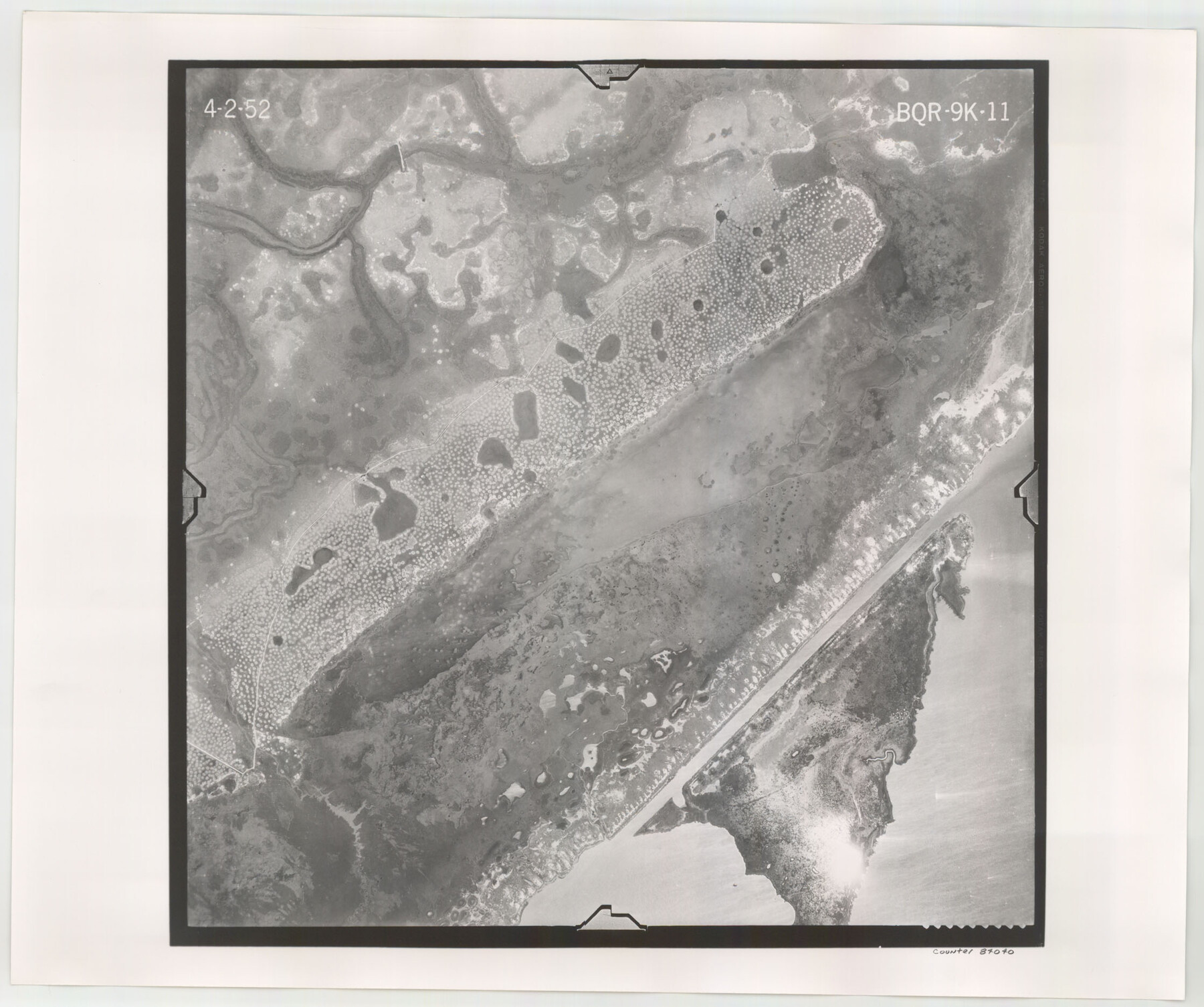
Flight Mission No. BQR-9K, Frame 11, Brazoria County
BQR-9K-11
-
Map/Doc
84040
-
Collection
General Map Collection
-
Object Dates
1952/4/2 (Creation Date)
-
People and Organizations
U. S. Department of Agriculture (Publisher)
-
Counties
Brazoria
-
Subjects
Aerial Photograph
-
Height x Width
18.7 x 22.4 inches
47.5 x 56.9 cm
-
Comments
Flown by Aero Exploration Company of Tulsa, Oklahoma.
Part of: General Map Collection
Lampasas County Boundary File 14

Print $10.00
- Digital $50.00
Lampasas County Boundary File 14
Size 13.3 x 8.3 inches
Map/Doc 56198
Flight Mission No. BRA-7M, Frame 197, Jefferson County

Print $20.00
- Digital $50.00
Flight Mission No. BRA-7M, Frame 197, Jefferson County
1953
Size 18.6 x 22.4 inches
Map/Doc 85565
Hamilton County Sketch File 21

Print $4.00
- Digital $50.00
Hamilton County Sketch File 21
1851
Size 12.9 x 8.2 inches
Map/Doc 24945
Burleson County Working Sketch 14

Print $20.00
- Digital $50.00
Burleson County Working Sketch 14
1980
Size 24.6 x 18.9 inches
Map/Doc 67733
Val Verde County Sketch File A1 1/2

Print $20.00
- Digital $50.00
Val Verde County Sketch File A1 1/2
Size 24.8 x 17.3 inches
Map/Doc 12539
Lamb County Working Sketch Graphic Index

Print $20.00
- Digital $50.00
Lamb County Working Sketch Graphic Index
1961
Size 43.8 x 34.1 inches
Map/Doc 76613
San Augustine County Sketch File 2

Print $4.00
San Augustine County Sketch File 2
1846
Size 8.2 x 8.2 inches
Map/Doc 35633
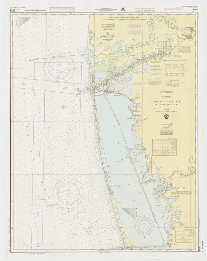
Southern Part of Laguna Madre
Print $20.00
- Digital $50.00
Southern Part of Laguna Madre
1975
Size 44.8 x 35.5 inches
Map/Doc 73544
Hutchinson County Rolled Sketch 38

Print $40.00
- Digital $50.00
Hutchinson County Rolled Sketch 38
1955
Size 43.6 x 67.7 inches
Map/Doc 9248
Eastland County Sketch File 4

Print $4.00
- Digital $50.00
Eastland County Sketch File 4
1861
Size 11.8 x 6.9 inches
Map/Doc 21568
Fayette County Working Sketch 10

Print $20.00
- Digital $50.00
Fayette County Working Sketch 10
1985
Size 27.1 x 38.5 inches
Map/Doc 69174
Hutchinson County Sketch File 17

Print $4.00
- Digital $50.00
Hutchinson County Sketch File 17
Size 6.9 x 8.8 inches
Map/Doc 27218
You may also like
Mapa del Ferro-Carril del Rio Grande, Condado de Cameron Texas

Mapa del Ferro-Carril del Rio Grande, Condado de Cameron Texas
Size 18.4 x 72.5 inches
Map/Doc 94564
[Sketch of part of Blks. 4, B5, 6, 2Z, M6, M8, and M13]
![89645, [Sketch of part of Blks. 4, B5, 6, 2Z, M6, M8, and M13], Twichell Survey Records](https://historictexasmaps.com/wmedia_w700/maps/89645-1.tif.jpg)
Print $40.00
- Digital $50.00
[Sketch of part of Blks. 4, B5, 6, 2Z, M6, M8, and M13]
Size 22.7 x 55.3 inches
Map/Doc 89645
Outer Continental Shelf Leasing Maps (Louisiana Offshore Operations)

Print $20.00
- Digital $50.00
Outer Continental Shelf Leasing Maps (Louisiana Offshore Operations)
1959
Size 17.9 x 14.0 inches
Map/Doc 76097
[Right of Way & Track Map, The Texas & Pacific Ry. Co. Main Line]
![64662, [Right of Way & Track Map, The Texas & Pacific Ry. Co. Main Line], General Map Collection](https://historictexasmaps.com/wmedia_w700/maps/64662.tif.jpg)
Print $20.00
- Digital $50.00
[Right of Way & Track Map, The Texas & Pacific Ry. Co. Main Line]
Size 11.0 x 18.5 inches
Map/Doc 64662
Sutton County Rolled Sketch 51

Print $20.00
- Digital $50.00
Sutton County Rolled Sketch 51
1950
Size 29.6 x 16.4 inches
Map/Doc 7891

Dimmit County Sketch File 61

Print $12.00
- Digital $50.00
Dimmit County Sketch File 61
1999
Size 11.4 x 8.8 inches
Map/Doc 21208
Throckmorton County Sketch File 12

Print $20.00
- Digital $50.00
Throckmorton County Sketch File 12
Size 16.2 x 22.3 inches
Map/Doc 12435
Yellowhouse Land Company's Subdivision of State Capitol Leagues Hockley County, Texas

Print $20.00
- Digital $50.00
Yellowhouse Land Company's Subdivision of State Capitol Leagues Hockley County, Texas
Size 30.7 x 24.9 inches
Map/Doc 92260
Austin County Sketch File 16

Print $74.00
- Digital $50.00
Austin County Sketch File 16
Size 14.3 x 8.8 inches
Map/Doc 13888
Flight Mission No. CUG-2P, Frame 83, Kleberg County

Print $20.00
- Digital $50.00
Flight Mission No. CUG-2P, Frame 83, Kleberg County
1956
Size 18.5 x 22.3 inches
Map/Doc 86215
Hill County Sketch File 21

Print $4.00
- Digital $50.00
Hill County Sketch File 21
1856
Size 11.1 x 8.8 inches
Map/Doc 26501