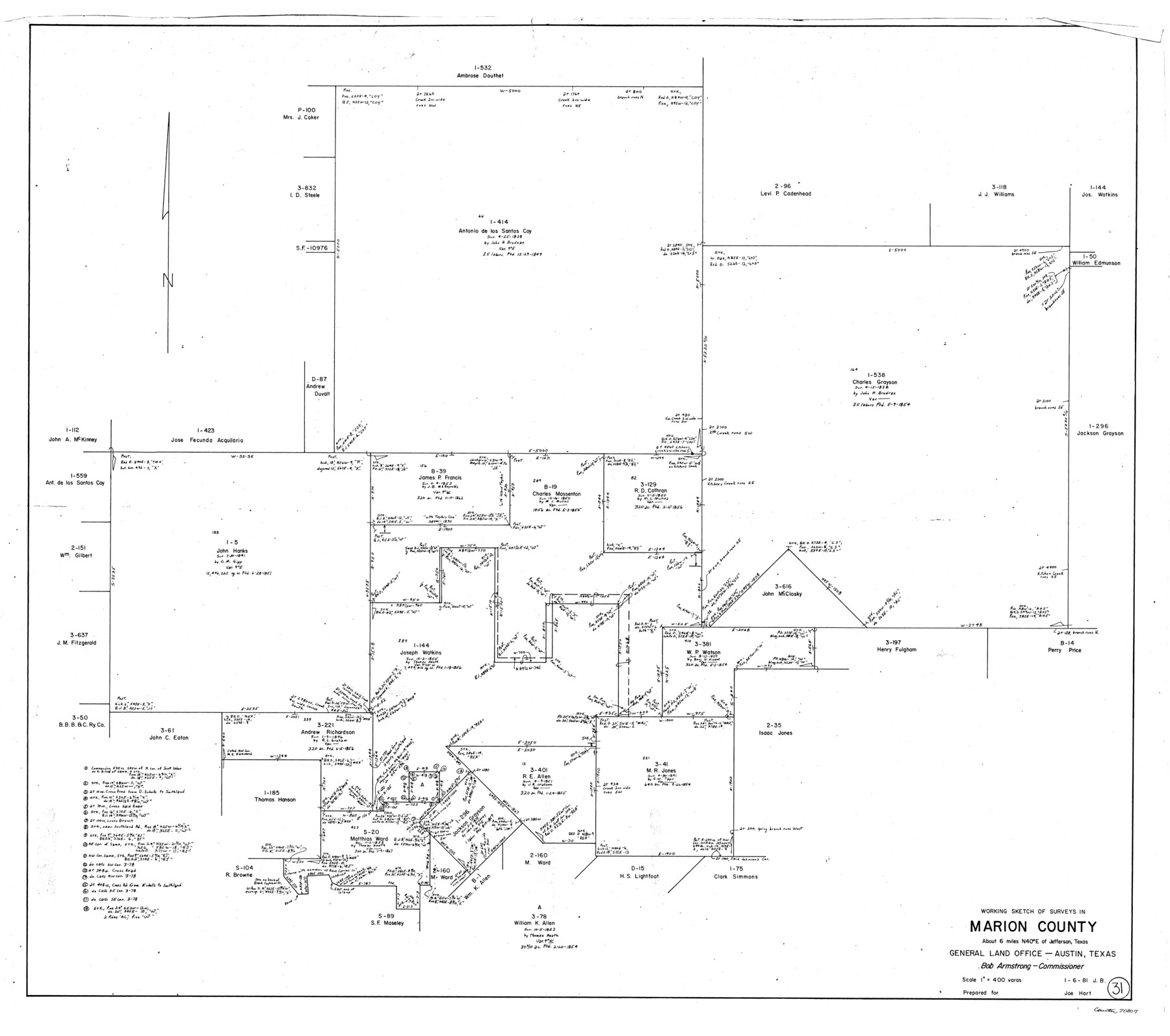
Marion County Working Sketch 31
-
Map/Doc
70807
-
Collection
General Map Collection
-
Object Dates
1/6/1981 (Creation Date)
-
People and Organizations
Jana Brod (Draftsman)
-
Counties
Marion
-
Subjects
Surveying Working Sketch
-
Height x Width
35.4 x 40.0 inches
89.9 x 101.6 cm
-
Scale
1" = 400 varas
Part of: General Map Collection
Val Verde County Sketch File 47

Print $20.00
- Digital $50.00
Val Verde County Sketch File 47
1951
Size 25.1 x 18.7 inches
Map/Doc 12588
Lampasas County Sketch File A

Print $4.00
- Digital $50.00
Lampasas County Sketch File A
1887
Size 11.3 x 9.0 inches
Map/Doc 29383
Kimble County Working Sketch 20

Print $20.00
- Digital $50.00
Kimble County Working Sketch 20
1929
Size 36.2 x 27.8 inches
Map/Doc 70088
Aransas County Rolled Sketch 33

Print $20.00
- Digital $50.00
Aransas County Rolled Sketch 33
1997
Size 24.5 x 36.8 inches
Map/Doc 78495
Lubbock County Sketch File 11

Print $20.00
- Digital $50.00
Lubbock County Sketch File 11
1914
Size 19.4 x 18.5 inches
Map/Doc 4585
Anderson County Sketch File 4

Print $6.00
- Digital $50.00
Anderson County Sketch File 4
Size 8.7 x 6.4 inches
Map/Doc 12743
Morris County Rolled Sketch 2A

Print $20.00
- Digital $50.00
Morris County Rolled Sketch 2A
Size 24.3 x 19.1 inches
Map/Doc 10242
Midland County Working Sketch 32

Print $40.00
- Digital $50.00
Midland County Working Sketch 32
1971
Size 51.3 x 35.5 inches
Map/Doc 71013
Flight Mission No. CGI-4N, Frame 183, Cameron County

Print $20.00
- Digital $50.00
Flight Mission No. CGI-4N, Frame 183, Cameron County
1955
Size 18.6 x 22.3 inches
Map/Doc 84686
Kinney County Working Sketch 12

Print $20.00
- Digital $50.00
Kinney County Working Sketch 12
1941
Size 26.7 x 32.1 inches
Map/Doc 70194
Hansford County Sketch File 9

Print $33.00
- Digital $50.00
Hansford County Sketch File 9
1928
Size 11.1 x 8.8 inches
Map/Doc 24963
Kenedy County Working Sketch 2a

Print $20.00
- Digital $50.00
Kenedy County Working Sketch 2a
1907
Size 22.2 x 20.9 inches
Map/Doc 70003
You may also like
Hudspeth County Rolled Sketch 37

Print $20.00
- Digital $50.00
Hudspeth County Rolled Sketch 37
1938
Size 23.3 x 29.8 inches
Map/Doc 6250

Presidio County Working Sketch 88

Print $20.00
- Digital $50.00
Presidio County Working Sketch 88
1971
Size 46.9 x 37.7 inches
Map/Doc 71765
General Highway Map, Wilbarger County, Texas

Print $20.00
General Highway Map, Wilbarger County, Texas
1940
Size 24.7 x 18.1 inches
Map/Doc 79278
[Leagues 247, 320, and 321]
![91291, [Leagues 247, 320, and 321], Twichell Survey Records](https://historictexasmaps.com/wmedia_w700/maps/91291-1.tif.jpg)
Print $2.00
- Digital $50.00
[Leagues 247, 320, and 321]
Size 8.2 x 15.1 inches
Map/Doc 91291
Trinity River, Balltown Sheet/Pilot Grove Creek

Print $20.00
- Digital $50.00
Trinity River, Balltown Sheet/Pilot Grove Creek
1938
Size 40.1 x 33.7 inches
Map/Doc 65196
Jeff Davis County Rolled Sketch 23

Print $20.00
- Digital $50.00
Jeff Davis County Rolled Sketch 23
1886
Size 24.9 x 25.4 inches
Map/Doc 7715
Walker County Working Sketch 18

Print $20.00
- Digital $50.00
Walker County Working Sketch 18
1991
Size 29.4 x 31.5 inches
Map/Doc 72298
[Sketch of area around R. D. Price and Berry Doolittle Surveys]
![91878, [Sketch of area around R. D. Price and Berry Doolittle Surveys], Twichell Survey Records](https://historictexasmaps.com/wmedia_w700/maps/91878-1.tif.jpg)
Print $20.00
- Digital $50.00
[Sketch of area around R. D. Price and Berry Doolittle Surveys]
Size 27.4 x 19.8 inches
Map/Doc 91878
[Maps of surveys in Reeves & Culberson Cos]
![61142, [Maps of surveys in Reeves & Culberson Cos], General Map Collection](https://historictexasmaps.com/wmedia_w700/maps/61142.tif.jpg)
Print $20.00
- Digital $50.00
[Maps of surveys in Reeves & Culberson Cos]
1937
Size 30.6 x 24.8 inches
Map/Doc 61142
Map of Austin Co.

Print $40.00
- Digital $50.00
Map of Austin Co.
1895
Size 49.3 x 43.6 inches
Map/Doc 4795
The Republic County of Bowie. December 29, 1845

Print $20.00
The Republic County of Bowie. December 29, 1845
2020
Size 19.5 x 21.7 inches
Map/Doc 96108