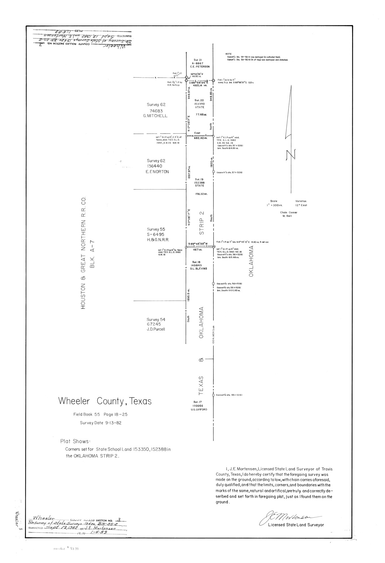
Wheeler County Rolled Sketch 3
Re-survey of state surveys 19 & 20, Block OS-2
-
Map/Doc
8239
-
Collection
General Map Collection
-
Object Dates
1982/9/13 (Survey Date)
1983/1/4 (File Date)
-
People and Organizations
James E. Mortensen (Surveyor/Engineer)
M. Bell (Chainman/Field Personnel)
-
Counties
Wheeler
-
Subjects
Surveying Rolled Sketch
-
Height x Width
31.9 x 21.9 inches
81.0 x 55.6 cm
-
Medium
mylar, print
-
Scale
1" = 300 varas
Part of: General Map Collection
King County Sketch File 4

Print $22.00
- Digital $50.00
King County Sketch File 4
Size 8.8 x 14.2 inches
Map/Doc 29022
Map of the Fort Worth and Denver City Railway, through Wilbarger County Texas, 1882

Print $40.00
- Digital $50.00
Map of the Fort Worth and Denver City Railway, through Wilbarger County Texas, 1882
Size 22.9 x 121.1 inches
Map/Doc 64426
Duval County Sketch File 4c

Print $4.00
- Digital $50.00
Duval County Sketch File 4c
1874
Size 10.8 x 8.7 inches
Map/Doc 21284
San Patricio County Rolled Sketch 46G

Print $40.00
- Digital $50.00
San Patricio County Rolled Sketch 46G
1983
Size 31.2 x 50.0 inches
Map/Doc 8378
Freestone County Sketch File 18

Print $4.00
- Digital $50.00
Freestone County Sketch File 18
1854
Size 9.7 x 8.2 inches
Map/Doc 23076
Fayette County Working Sketch 8

Print $20.00
- Digital $50.00
Fayette County Working Sketch 8
1981
Size 14.4 x 11.5 inches
Map/Doc 69172
Jalisco Banco Number 67, cut from Mexico in 1909

Print $3.00
- Digital $50.00
Jalisco Banco Number 67, cut from Mexico in 1909
1912
Size 14.2 x 11.2 inches
Map/Doc 2064

Jefferson County Sketch File 42

Print $20.00
- Digital $50.00
Jefferson County Sketch File 42
1945
Size 25.5 x 35.1 inches
Map/Doc 11876
Anderson County Sketch File 30

Print $4.00
- Digital $50.00
Anderson County Sketch File 30
1989
Size 11.3 x 8.6 inches
Map/Doc 12816

Clay County Boundary File 12

Print $8.00
- Digital $50.00
Clay County Boundary File 12
Size 14.3 x 8.8 inches
Map/Doc 51406
You may also like
Newton County Sketch File 44

Print $8.00
- Digital $50.00
Newton County Sketch File 44
1945
Size 11.2 x 8.6 inches
Map/Doc 32441
Lamar County, Texas

Print $20.00
- Digital $50.00
Lamar County, Texas
1870
Size 21.5 x 18.1 inches
Map/Doc 738
Corpus Christi and Rio Grande Railway Company

Print $20.00
Corpus Christi and Rio Grande Railway Company
Size 14.6 x 24.0 inches
Map/Doc 95314
Dickens County Working Sketch 11

Print $40.00
- Digital $50.00
Dickens County Working Sketch 11
1969
Size 52.6 x 37.8 inches
Map/Doc 68659
Kleberg County Rolled Sketch 10-42

Print $20.00
- Digital $50.00
Kleberg County Rolled Sketch 10-42
1952
Size 42.7 x 36.4 inches
Map/Doc 9380
Ector County Working Sketch 29

Print $40.00
- Digital $50.00
Ector County Working Sketch 29
1971
Size 43.9 x 63.4 inches
Map/Doc 68872
Navigation Maps of Gulf Intracoastal Waterway, Port Arthur to Brownsville, Texas

Print $4.00
- Digital $50.00
Navigation Maps of Gulf Intracoastal Waterway, Port Arthur to Brownsville, Texas
1951
Size 16.6 x 21.3 inches
Map/Doc 65431
Harris County Working Sketch 109

Print $20.00
- Digital $50.00
Harris County Working Sketch 109
1981
Size 21.4 x 27.2 inches
Map/Doc 66001
Sketch of Resurvey, Township 5 North. Block 36. Texas and Pacific Railroad Company, Dawson County

Print $20.00
- Digital $50.00
Sketch of Resurvey, Township 5 North. Block 36. Texas and Pacific Railroad Company, Dawson County
1926
Size 24.6 x 25.0 inches
Map/Doc 92572
Val Verde County Working Sketch 64

Print $20.00
- Digital $50.00
Val Verde County Working Sketch 64
1959
Size 19.0 x 43.0 inches
Map/Doc 72199
[Surveys along Red River in Hartley County]
![90739, [Surveys along Red River in Hartley County], Twichell Survey Records](https://historictexasmaps.com/wmedia_w700/maps/90739-1.tif.jpg)
Print $20.00
- Digital $50.00
[Surveys along Red River in Hartley County]
Size 22.0 x 16.7 inches
Map/Doc 90739
[Stephen F. Austin's Map of Texas]
![95825, [Stephen F. Austin's Map of Texas], Non-GLO Digital Images](https://historictexasmaps.com/wmedia_w700/maps/95825.tif.jpg)
[Stephen F. Austin's Map of Texas]
1829
Size 21.7 x 17.9 inches
Map/Doc 95825