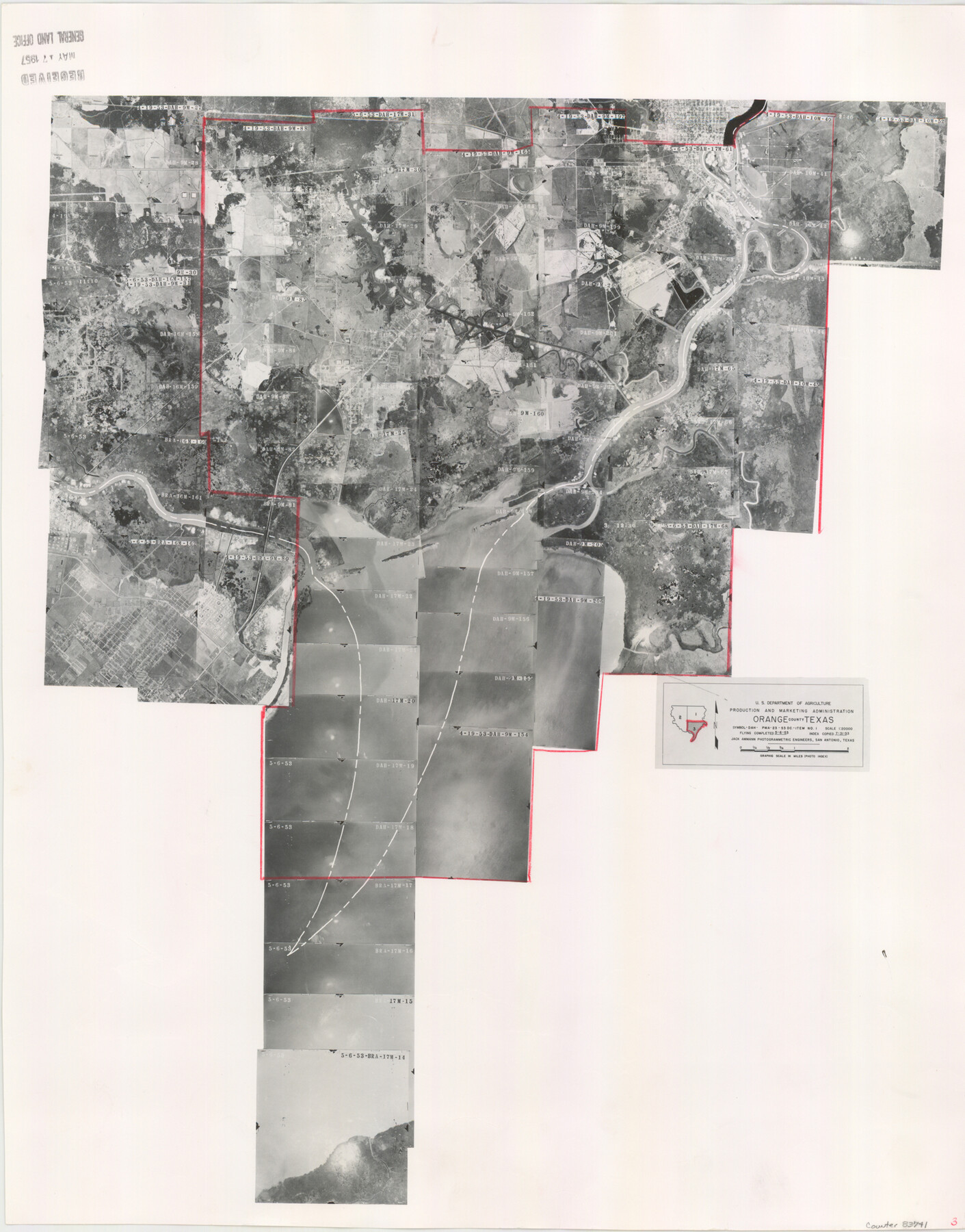
Orange County Aerial Photograph Index Sheet 3
Orange County Aerial Photograph Index 3
-
Map/Doc
83741
-
Collection
General Map Collection
-
Object Dates
1953/7/31 (Creation Date)
-
People and Organizations
U. S. Department of Agriculture (Publisher)
-
Counties
Orange
-
Subjects
Aerial Photograph
-
Height x Width
22.8 x 17.8 inches
57.9 x 45.2 cm
-
Comments
Flying completed May 6, 1953 by Jack Ammann Photogrammetric Engineers of San Antonio, Texas.
Received in office May 17, 1957.
Part of: General Map Collection
Van Zandt County Rolled Sketch 3

Print $20.00
- Digital $50.00
Van Zandt County Rolled Sketch 3
1946
Size 23.6 x 36.7 inches
Map/Doc 8145

Crockett County Rolled Sketch 37

Print $20.00
- Digital $50.00
Crockett County Rolled Sketch 37
Size 36.7 x 29.3 inches
Map/Doc 5589
Flight Mission No. BRA-6T, Frame 117, Jefferson County

Print $20.00
- Digital $50.00
Flight Mission No. BRA-6T, Frame 117, Jefferson County
1957
Size 18.6 x 18.4 inches
Map/Doc 85786
Blanco County Working Sketch 12

Print $3.00
- Digital $50.00
Blanco County Working Sketch 12
1943
Size 11.9 x 10.9 inches
Map/Doc 67372

Terry County Boundary File 2

Print $10.00
- Digital $50.00
Terry County Boundary File 2
Size 9.1 x 8.8 inches
Map/Doc 59204

Kinney County Working Sketch 1

Print $20.00
- Digital $50.00
Kinney County Working Sketch 1
Size 22.6 x 24.0 inches
Map/Doc 70183
Plat showing survey of tracts in the C. A. West survey A-337 and the Wm. Standiferd survey A-301 in Bastrop County as surveyed for the Veteran's Land Board

Print $20.00
- Digital $50.00
Plat showing survey of tracts in the C. A. West survey A-337 and the Wm. Standiferd survey A-301 in Bastrop County as surveyed for the Veteran's Land Board
1992
Size 34.9 x 46.8 inches
Map/Doc 61151
Goliad County Rolled Sketch 1

Print $20.00
- Digital $50.00
Goliad County Rolled Sketch 1
1941
Size 31.4 x 38.5 inches
Map/Doc 6023

You may also like
Flight Mission No. DAG-21K, Frame 29, Matagorda County

Print $20.00
- Digital $50.00
Flight Mission No. DAG-21K, Frame 29, Matagorda County
1952
Size 18.5 x 16.1 inches
Map/Doc 86396
![89832, [Yates Area], Twichell Survey Records](https://historictexasmaps.com/wmedia_w700/maps/89832-1.tif.jpg)
Denton County Boundary File 4 and 4a and 4b and 4c

Print $14.00
- Digital $50.00
Denton County Boundary File 4 and 4a and 4b and 4c
Size 11.2 x 8.5 inches
Map/Doc 52441
[Sketch for Mineral Application 19144 - Pecos River Bed]
![65574, [Sketch for Mineral Application 19144 - Pecos River Bed], General Map Collection](https://historictexasmaps.com/wmedia_w700/maps/65574.tif.jpg)
Print $20.00
- Digital $50.00
[Sketch for Mineral Application 19144 - Pecos River Bed]
1927
Size 46.2 x 45.1 inches
Map/Doc 65574
[Surveys along the Nueces River, San Patricio District]
![69739, [Surveys along the Nueces River, San Patricio District], General Map Collection](https://historictexasmaps.com/wmedia_w700/maps/69739.tif.jpg)
Print $2.00
- Digital $50.00
[Surveys along the Nueces River, San Patricio District]
1842
Size 11.3 x 7.7 inches
Map/Doc 69739
Hardin County Sketch File 31

Print $2.00
- Digital $50.00
Hardin County Sketch File 31
Size 8.5 x 7.1 inches
Map/Doc 25162
[Map of Matagorda County]
![3841, [Map of Matagorda County], General Map Collection](https://historictexasmaps.com/wmedia_w700/maps/3841.tif.jpg)
Print $20.00
- Digital $50.00
[Map of Matagorda County]
Size 24.4 x 25.6 inches
Map/Doc 3841
Glasscock County Working Sketch 3

Print $20.00
- Digital $50.00
Glasscock County Working Sketch 3
Size 16.8 x 28.0 inches
Map/Doc 63176
East line Stonewall Co./West line Haskell Co.

Print $20.00
- Digital $50.00
East line Stonewall Co./West line Haskell Co.
1893
Size 7.5 x 39.1 inches
Map/Doc 91929
Oso Creek, Rodd Field (P-1) Sheet

Print $20.00
- Digital $50.00
Oso Creek, Rodd Field (P-1) Sheet
1942
Size 33.2 x 34.0 inches
Map/Doc 65096
Sketch C Showing the Progress of the Survey in Section III From 1843 to 1851

Print $20.00
- Digital $50.00
Sketch C Showing the Progress of the Survey in Section III From 1843 to 1851
1851
Size 35.7 x 23.0 inches
Map/Doc 97205
Dickens County Sketch File 2

Print $20.00
- Digital $50.00
Dickens County Sketch File 2
1913
Size 22.0 x 32.3 inches
Map/Doc 11316